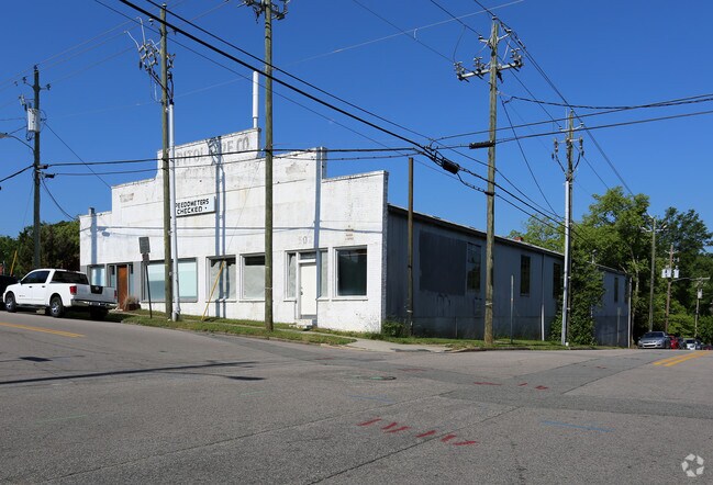
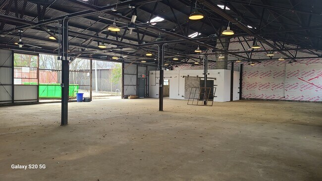
Property Record
518 S West St, Raleigh, NC 27601

Property Detail
518 S West St
1703.10-46-7736-000
LO2 CABARRUS WEST PROPERTY LLC BM2019-01
Warehouse
Wake
IX-4
North Carolina
B and X Area of moderate flood hazard, usually the area between the limits of the 100-year and 500-year floods.
2
2025
1.83 AC
2025
West Raleigh
050100
Raleigh/Durham
19,417 SF
Raleigh-Cary, NC
NEARBY LISTINGS FOR SALE OR LEASE
DEMOGRAPHICS near 518 S West St
1 mile
3 mile
5 mile
2025 Total Population
17,781
118,033
230,602
2030 Population
19,444
127,698
249,293
Pop Growth 2025-2030
+ 9.35%
+ 8.19%
+ 8.11%
Average Age
37
36
37
2025 Total Households
9,416
47,968
96,756
HH Growth 2025-2030
+ 10.26%
+ 9.26%
+ 8.89%
Median Household Inc
$86,031
$74,434
$77,522
Avg Household Size
1.60
2.10
2.20
2025 Avg HH Vehicles
1.00
2.00
2.00
Median Home Value
$661,915
$583,405
$481,777
Median Year Built
2010
1988
1991
Nearby Places
Map Layers
Map Styles
 Street
 Aerial
Layers
 Traffic
 Biking
Places
Listings with unknown addresses are not visible on the map
- Restaurants
- Banks
- Shops
- Fitness
- Groceries
PUBLIC TRANSPORTATION
COMMUTER RAIL
Raleigh Union Station (Piedmont - North Carolina by Train (NC Train))
Drive
Walk
Distance
Raleigh Union Station (Piedmont - North Carolina by Train (NC Train))
1 min
8 min
0.4 mi
Cary Station (Piedmont - North Carolina by Train (NC Train))
Drive
Walk
Distance
Cary Station (Piedmont - North Carolina by Train (NC Train))
16 min
8.6 mi
AIRPORT
Raleigh-Durham International
Drive
Walk
Distance
Raleigh-Durham International
23 min
14.2 mi
Freight Ports
Port of Wilmington
Drive
Walk
Distance
Port of Wilmington
153 min
133.5 mi
SALE & LEASE HISTORY
LISTING DATE
SALE/LEASE

Jun 15, 2020
For Lease
Jul 18, 2024
For Lease
Nearby Properties
Address
Land Use
TOTAL SIZE
Lot Size
Zoning
Address
Land Use
TOTAL SIZE
Lot Size
Zoning
5,616,802 SF
507.97 AC
OX-12
Address
Land Use
TOTAL SIZE
Lot Size
Zoning
972,279 SF
4.05 AC
DX-20
Address
Land Use
TOTAL SIZE
Lot Size
Zoning
1,109,877 SF
746.53 AC
CMP
Address
Land Use
TOTAL SIZE
Lot Size
Zoning
1,597,789 SF
13.35 AC
DX-20
Address
Land Use
TOTAL SIZE
Lot Size
Zoning
854,180 SF
210.81 AC
OX-4
Address
Land Use
TOTAL SIZE
Lot Size
Zoning
458,830 SF
3.98 AC
DX-20
Address
Land Use
TOTAL SIZE
Lot Size
Zoning
1,810,132 SF
OX-12
Address
Land Use
TOTAL SIZE
Lot Size
Zoning
706,810 SF
40.78 AC
IH
Address
Land Use
TOTAL SIZE
Lot Size
Zoning
573,338 SF
19.34 AC
IH
Address
Land Use
TOTAL SIZE
Lot Size
Zoning
675,817 SF
3.56 AC
DX-12
Address
Land Use
TOTAL SIZE
Lot Size
Zoning
372,222 SF
9.64 AC
DX-12
Address
Land Use
TOTAL SIZE
Lot Size
Zoning
250,448 SF
25.28 AC
OX-3
Address
Land Use
TOTAL SIZE
Lot Size
Zoning
982,323 SF
154.02 AC
OX-7
Address
Land Use
TOTAL SIZE
Lot Size
Zoning
517,826 SF
2.52 AC
DX-7
Address
Land Use
TOTAL SIZE
Lot Size
Zoning
179,565 SF
1.10 AC
DX-7
Address
Land Use
TOTAL SIZE
Lot Size
Zoning
524,391 SF
4.13 AC
NX-5
Address
Land Use
TOTAL SIZE
Lot Size
Zoning
344,814 SF
1.95 AC
DX-40
Address
Land Use
TOTAL SIZE
Lot Size
Zoning
654,148 SF
1.21 AC
DX-40
Address
Land Use
TOTAL SIZE
Lot Size
Zoning
462,217 SF
1.01 AC
DX-20
Address
Land Use
TOTAL SIZE
Lot Size
Zoning
834,950 SF
3.91 AC
OX-12
Address
Land Use
TOTAL SIZE
Lot Size
Zoning
561,966 SF
3.81 AC
IX-7
Address
Land Use
TOTAL SIZE
Lot Size
Zoning
426,539 SF
2.90 AC
NX-5
Address
Land Use
TOTAL SIZE
Lot Size
Zoning
765,252 SF
1.72 AC
DX-20
Address
Land Use
TOTAL SIZE
Lot Size
Zoning
159,921 SF
4.99 AC
DX-5
Address
Land Use
TOTAL SIZE
Lot Size
Zoning
376,902 SF
189.85 AC
OX-3
Address
Land Use
TOTAL SIZE
Lot Size
Zoning
40,024 SF
6.19 AC
DX-3
Address
Land Use
TOTAL SIZE
Lot Size
Zoning
613,248 SF
2.20 AC
IND-2
Address
Land Use
TOTAL SIZE
Lot Size
Zoning
580,268 SF
9.02 AC
PD
Address
Land Use
TOTAL SIZE
Lot Size
Zoning
931,884 SF
10.21 AC
CMP
Address
Land Use
TOTAL SIZE
Lot Size
Zoning
197,029 SF
6.27 AC
DX-5
The World's #1 Commercial Real Estate Marketplace
Connect with us
© 2026 CoStar Group
The information above has been obtained from sources believed reliable. While we do not doubt its accuracy we have not verified it and make no guarantee, warranty or representation about it. It is your responsibility to independently confirm its accuracy and completeness. Any projections, opinions, assumptions, or estimates used are for example only and do not represent the current or future performance of the property. The value of this transaction to you depends on tax and other factors which should be evaluated by your tax, financial, and legal advisors. You and your advisors should conduct a careful, independent investigation of the property to determine to your satisfaction the suitability of the property for your needs.