Property Record
Cable Ranch Rd, San Antonio, TX 78227


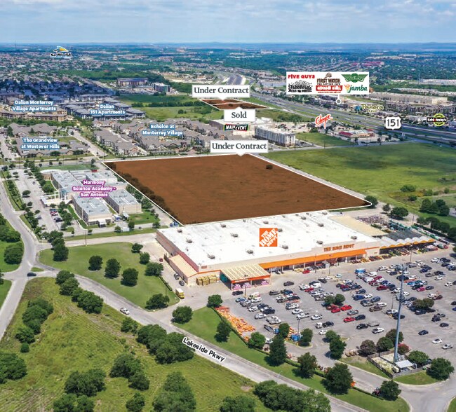
Property Detail
Cable Ranch Rd
San Antonio-New Braunfels, TX
NCB 15329 P-4D (.801 AC) & P-1M (.292 AC) BLK 34 P-6 (9.154 AC) 2016 RESURVEY PER DEED 17228/1518, 2008 SPLIT PER DEED 12985/1843 EXC 07-07-07.
15329-000-0046
BEXAR
Vacantlandnec
Texas
B and X Area of moderate flood hazard, usually the area between the limits of the 100-year and 500-year floods.
46
2024
10.25 AC
2025
Far West
171802
San Antonio
NEARBY LISTINGS FOR SALE OR LEASE
DEMOGRAPHICS near Cable Ranch Rd
1 mile
3 mile
5 mile
2025 Total Population
15,488
124,068
307,380
2030 Population
16,481
129,801
323,825
Pop Growth 2025-2030
+ 6.41%
+ 4.62%
+ 5.35%
Average Age
33
36
35
2025 Total Households
6,138
44,076
101,524
HH Growth 2025-2030
+ 6.60%
+ 4.79%
+ 5.40%
Median Household Inc
$58,630
$67,371
$68,810
Avg Household Size
2.50
2.80
2.90
2025 Avg HH Vehicles
2.00
2.00
2.00
Median Home Value
$239,729
$230,052
$235,125
Median Year Built
2008
1996
1993
Nearby Places
Map Layers
Map Styles
 Street
 Aerial
Transit
 Traffic
 Biking
Places
Listings with unknown addresses are not visible on the map
- Restaurants
- Banks
- Shops
- Fitness
- Groceries
PUBLIC TRANSPORTATION
AIRPORT
San Antonio International
Drive
Walk
Distance
San Antonio International
18 min
13.9 mi
Freight Ports
Port of Corpus Christi
Drive
Walk
Distance
Port of Corpus Christi
158 min
152.6 mi
SALE & LEASE HISTORY
LISTING DATE
SALE/LEASE

Sep 24, 2016
For Sale
May 19, 2022
For Lease
May 19, 2022
For Sale
Nearby Properties
Address
Land Use
TOTAL SIZE
Lot Size
Zoning
Address
Land Use
TOTAL SIZE
Lot Size
Zoning
486,228 SF
50.05 AC
Address
Land Use
TOTAL SIZE
Lot Size
Zoning
339,795 SF
24.27 AC
Address
Land Use
TOTAL SIZE
Lot Size
Zoning
469,808 SF
36 AC
Address
Land Use
TOTAL SIZE
Lot Size
Zoning
593,760 SF
69.28 AC
Address
Land Use
TOTAL SIZE
Lot Size
Zoning
236,594 SF
25.35 AC
Address
Land Use
TOTAL SIZE
Lot Size
Zoning
185,751 SF
21.60 AC
Address
Land Use
TOTAL SIZE
Lot Size
Zoning
171,142 SF
21.60 AC
Address
Land Use
TOTAL SIZE
Lot Size
Zoning
370,870 SF
27.27 AC
Address
Land Use
TOTAL SIZE
Lot Size
Zoning
118,393 SF
28.05 AC
Address
Land Use
TOTAL SIZE
Lot Size
Zoning
341,212 SF
15 AC
Address
Land Use
TOTAL SIZE
Lot Size
Zoning
123,595 SF
21.60 AC
Address
Land Use
TOTAL SIZE
Lot Size
Zoning
369,951 SF
21.42 AC
Address
Land Use
TOTAL SIZE
Lot Size
Zoning
331,109 SF
14.44 AC
Address
Land Use
TOTAL SIZE
Lot Size
Zoning
109,425 SF
30.63 AC
Address
Land Use
TOTAL SIZE
Lot Size
Zoning
361,708 SF
17.83 AC
Address
Land Use
TOTAL SIZE
Lot Size
Zoning
532,921 SF
21.80 AC
Address
Land Use
TOTAL SIZE
Lot Size
Zoning
368,012 SF
22.27 AC
Address
Land Use
TOTAL SIZE
Lot Size
Zoning
50,135 SF
10.96 AC
Address
Land Use
TOTAL SIZE
Lot Size
Zoning
336,383 SF
18.71 AC
Address
Land Use
TOTAL SIZE
Lot Size
Zoning
275,270 SF
11.97 AC
Address
Land Use
TOTAL SIZE
Lot Size
Zoning
286,006 SF
13.43 AC
Address
Land Use
TOTAL SIZE
Lot Size
Zoning
202,122 SF
20.56 AC
Address
Land Use
TOTAL SIZE
Lot Size
Zoning
360,108 SF
24 AC
Address
Land Use
TOTAL SIZE
Lot Size
Zoning
337,360 SF
13.33 AC
Address
Land Use
TOTAL SIZE
Lot Size
Zoning
241,445 SF
15.86 AC
Address
Land Use
TOTAL SIZE
Lot Size
Zoning
324,175 SF
39.17 AC
Address
Land Use
TOTAL SIZE
Lot Size
Zoning
263,255 SF
14.59 AC
Address
Land Use
TOTAL SIZE
Lot Size
Zoning
263,976 SF
17.42 AC
Address
Land Use
TOTAL SIZE
Lot Size
Zoning
228,973 SF
11.23 AC
Address
Land Use
TOTAL SIZE
Lot Size
Zoning
228,494 SF
12.74 AC
The World's #1 Commercial Real Estate Marketplace
Connect with us
© 2026 CoStar Group
The information above has been obtained from sources believed reliable. While we do not doubt its accuracy we have not verified it and make no guarantee, warranty or representation about it. It is your responsibility to independently confirm its accuracy and completeness. Any projections, opinions, assumptions, or estimates used are for example only and do not represent the current or future performance of the property. The value of this transaction to you depends on tax and other factors which should be evaluated by your tax, financial, and legal advisors. You and your advisors should conduct a careful, independent investigation of the property to determine to your satisfaction the suitability of the property for your needs.