Property Record
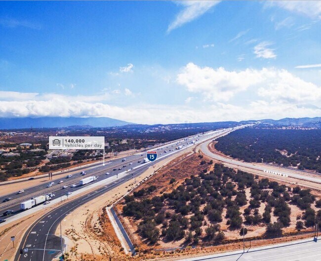
Caliente Rd, Hesperia, CA 92344

Property Detail
Caliente Rd
Riverside-San Bernardino-Ontario, CA
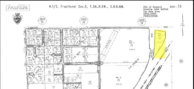
ALL THAT PORTION OF PARCEL 1 OF PARCEL MAP NO. 11716, IN THE CITY OF HESPERIA, COUNTY OF SAN BERNARDINO, STATE OF CALIFORNIA, PER MAP RECORDED IN PARCEL MAP BOOK 136, PAGES 86 AND 87 IN THE OFFICE OF THE COUNTY RECORDER OF SAID COUNTY, LYING WESTERLY
0357-591-60
SAN BERNARDINO
Vacantlandnec
California
B and X Area of moderate flood hazard, usually the area between the limits of the 100-year and 500-year floods.
5.77 AC
2025
Mojave River Valley
2025
Inland Empire (California)
010042
NEARBY LISTINGS FOR SALE OR LEASE
DEMOGRAPHICS near Caliente Rd
1 mile
3 mile
5 mile
2025 Total Population
885
9,203
37,635
2030 Population
891
9,426
38,639
Pop Growth 2025-2030
+ 0.68%
+ 2.42%
+ 2.67%
Average Age
40
38
37
2025 Total Households
273
2,665
10,732
HH Growth 2025-2030
+ 0.37%
+ 2.25%
+ 2.65%
Median Household Inc
$116,666
$101,760
$97,268
Avg Household Size
3.20
3.40
3.40
2025 Avg HH Vehicles
3.00
3.00
3.00
Median Home Value
$710,000
$624,143
$480,269
Median Year Built
2001
2002
2002
Nearby Places
Map Layers
Map Styles
 Street
 Aerial
Layers
 Traffic
 Biking
Places
Listings with unknown addresses are not visible on the map
- Restaurants
- Banks
- Shops
- Fitness
- Groceries
PUBLIC TRANSPORTATION
AIRPORT
Ontario International
Drive
Walk
Distance
Ontario International
39 min
33.1 mi
Freight Ports
Port of Long Beach
Drive
Walk
Distance
Port of Long Beach
101 min
85.2 mi
SALE & LEASE HISTORY
LISTING DATE
SALE/LEASE

Mar 03, 2021
For Sale
Nearby Properties
Address
Land Use
TOTAL SIZE
Lot Size
Zoning
Address
Land Use
TOTAL SIZE
Lot Size
Zoning
1,226,588 SF
54.88 AC
Address
Land Use
TOTAL SIZE
Lot Size
Zoning
1,055,350 SF
59.71 AC
Address
Land Use
TOTAL SIZE
Lot Size
Zoning
1,003,485 SF
54.80 AC
Address
Land Use
TOTAL SIZE
Lot Size
Zoning
62.93 AC
Address
Land Use
TOTAL SIZE
Lot Size
Zoning
38.91 AC
Address
Land Use
TOTAL SIZE
Lot Size
Zoning
37.37 AC
Address
Land Use
TOTAL SIZE
Lot Size
Zoning
38.45 AC
Address
Land Use
TOTAL SIZE
Lot Size
Zoning
10.31 AC
Address
Land Use
TOTAL SIZE
Lot Size
Zoning
150,000 SF
12.53 AC
Address
Land Use
TOTAL SIZE
Lot Size
Zoning
10,923 SF
17.01 AC
Address
Land Use
TOTAL SIZE
Lot Size
Zoning
17.57 AC
Address
Land Use
TOTAL SIZE
Lot Size
Zoning
34.57 AC
Address
Land Use
TOTAL SIZE
Lot Size
Zoning
22,500 SF
6.32 AC
Address
Land Use
TOTAL SIZE
Lot Size
Zoning
17.58 AC
Address
Land Use
TOTAL SIZE
Lot Size
Zoning
69,600 SF
8.40 AC
Address
Land Use
TOTAL SIZE
Lot Size
Zoning
34,168 SF
15.07 AC
Address
Land Use
TOTAL SIZE
Lot Size
Zoning
6,473 SF
1.34 AC
Address
Land Use
TOTAL SIZE
Lot Size
Zoning
4,798 SF
1.24 AC
Address
Land Use
TOTAL SIZE
Lot Size
Zoning
6,327 SF
1.48 AC
Address
Land Use
TOTAL SIZE
Lot Size
Zoning
54.74 AC
Address
Land Use
TOTAL SIZE
Lot Size
Zoning
22,368 SF
10.41 AC
Address
Land Use
TOTAL SIZE
Lot Size
Zoning
45.98 AC
Address
Land Use
TOTAL SIZE
Lot Size
Zoning
10,981 SF
10.19 AC
Address
Land Use
TOTAL SIZE
Lot Size
Zoning
43.26 AC
Address
Land Use
TOTAL SIZE
Lot Size
Zoning
4,280 SF
1.07 AC
Address
Land Use
TOTAL SIZE
Lot Size
Zoning
50,625 SF
19.82 AC
OHFW
Address
Land Use
TOTAL SIZE
Lot Size
Zoning
1,888 SF
0.81 AC
Address
Land Use
TOTAL SIZE
Lot Size
Zoning
40.50 AC
Address
Land Use
TOTAL SIZE
Lot Size
Zoning
The World's #1 Commercial Real Estate Marketplace
Connect with us
© 2026 CoStar Group
The information above has been obtained from sources believed reliable. While we do not doubt its accuracy we have not verified it and make no guarantee, warranty or representation about it. It is your responsibility to independently confirm its accuracy and completeness. Any projections, opinions, assumptions, or estimates used are for example only and do not represent the current or future performance of the property. The value of this transaction to you depends on tax and other factors which should be evaluated by your tax, financial, and legal advisors. You and your advisors should conduct a careful, independent investigation of the property to determine to your satisfaction the suitability of the property for your needs.