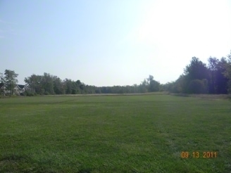
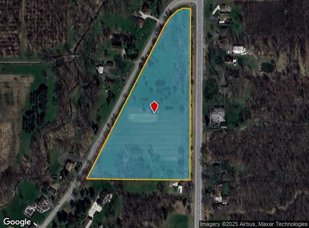
Property Record
Calkins Rd, Youngstown, NY 14174

Property Detail
Calkins Rd
293489-059-000-0002-058-012
Niagara
Residentialacreage
New York
X
58.012
36063C0160E
9.40 AC
2016
Outlying Niagara County
2024
Buffalo/Niagara Falls
024501
Buffalo-Cheektowaga, NY
NEARBY LISTINGS FOR SALE OR LEASE
-
-
No Photo
-
View all Youngstown listings for sale on LoopNet.com
DEMOGRAPHICS near Calkins Rd
1 mile
3 mile
5 mile
2024 Total Population
476
6,458
16,770
2029 Population
484
6,407
16,633
Pop Growth 2024-2029
+ 1.68%
(0.79%)
(0.82%)
Average Age
45
46
47
2024 Total Households
209
2,731
7,322
HH Growth 2024-2029
+ 1.91%
(0.77%)
(0.81%)
Median Household Inc
$65,625
$75,457
$74,959
Avg Household Size
2.20
2.30
2.20
2024 Avg HH Vehicles
2.00
2.00
2.00
Median Home Value
$186,805
$249,184
$249,561
Median Year Built
1975
1966
1966
Nearby Places
Map Layers
Map Styles
 Street
 Aerial
Transit
 Traffic
 Biking
Places
Listings with unknown addresses are not visible on the map
- Restaurants
- Banks
- Shops
- Fitness
- Groceries
PUBLIC TRANSPORTATION
COMMUTER RAIL
Niagara Falls Amtrak Station (Empire Service - Amtrak, Maple Leaf - Amtrak)
Drive
Walk
Distance
Niagara Falls Amtrak Station (Empire Service - Amtrak, Maple Leaf - Amtrak)
15 min
9.2 mi
AIRPORT
Niagara Falls International
Drive
Walk
Distance
Niagara Falls International
21 min
12.7 mi
Buffalo Niagara International
Drive
Walk
Distance
Buffalo Niagara International
48 min
33.3 mi
Freight Ports
Port of Toledo
Drive
Walk
Distance
Port of Toledo
372 min
302.9 mi
SALE & LEASE HISTORY
LISTING DATE
SALE/LEASE

Sep 24, 2016
For Sale
Nearby Properties
Address
Land Use
TOTAL SIZE
Lot Size
Zoning
Address
Land Use
TOTAL SIZE
Lot Size
Zoning
49,356 SF
270.30 AC
Address
Land Use
TOTAL SIZE
Lot Size
Zoning
216 SF
482.53 AC
RC
Address
Land Use
TOTAL SIZE
Lot Size
Zoning
11,939 SF
45.20 AC
Address
Land Use
TOTAL SIZE
Lot Size
Zoning
Address
Land Use
TOTAL SIZE
Lot Size
Zoning
140,466 SF
103.40 AC
Address
Land Use
TOTAL SIZE
Lot Size
Zoning
784 SF
327.32 AC
Address
Land Use
TOTAL SIZE
Lot Size
Zoning
351.80 AC
R1
Address
Land Use
TOTAL SIZE
Lot Size
Zoning
Address
Land Use
TOTAL SIZE
Lot Size
Zoning
12,140 SF
19 AC
R1
Address
Land Use
TOTAL SIZE
Lot Size
Zoning
792 SF
11.20 AC
I1
Address
Land Use
TOTAL SIZE
Lot Size
Zoning
43,194 SF
102.12 AC
Address
Land Use
TOTAL SIZE
Lot Size
Zoning
8,600 SF
10.50 AC
Address
Land Use
TOTAL SIZE
Lot Size
Zoning
780 SF
29.10 AC
Address
Land Use
TOTAL SIZE
Lot Size
Zoning
9,620 SF
251.18 AC
Address
Land Use
TOTAL SIZE
Lot Size
Zoning
Address
Land Use
TOTAL SIZE
Lot Size
Zoning
Address
Land Use
TOTAL SIZE
Lot Size
Zoning
Address
Land Use
TOTAL SIZE
Lot Size
Zoning
27.90 AC
Address
Land Use
TOTAL SIZE
Lot Size
Zoning
23.29 AC
Address
Land Use
TOTAL SIZE
Lot Size
Zoning
Address
Land Use
TOTAL SIZE
Lot Size
Zoning
11,054 SF
1.07 AC
Address
Land Use
TOTAL SIZE
Lot Size
Zoning
Address
Land Use
TOTAL SIZE
Lot Size
Zoning
Address
Land Use
TOTAL SIZE
Lot Size
Zoning
Address
Land Use
TOTAL SIZE
Lot Size
Zoning
5,898 SF
0.44 AC
Address
Land Use
TOTAL SIZE
Lot Size
Zoning
4,608 SF
2.24 AC
Address
Land Use
TOTAL SIZE
Lot Size
Zoning
14,400 SF
55 AC
Address
Land Use
TOTAL SIZE
Lot Size
Zoning
Address
Land Use
TOTAL SIZE
Lot Size
Zoning
415.20 AC
Address
Land Use
TOTAL SIZE
Lot Size
Zoning
2,030 SF
6.70 AC
R1
The World's #1 Commercial Real Estate Marketplace
Connect with us
© 2026 CoStar Group
The information above has been obtained from sources believed reliable. While we do not doubt its accuracy we have not verified it and make no guarantee, warranty or representation about it. It is your responsibility to independently confirm its accuracy and completeness. Any projections, opinions, assumptions, or estimates used are for example only and do not represent the current or future performance of the property. The value of this transaction to you depends on tax and other factors which should be evaluated by your tax, financial, and legal advisors. You and your advisors should conduct a careful, independent investigation of the property to determine to your satisfaction the suitability of the property for your needs.