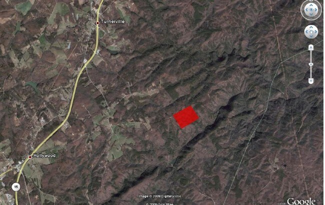
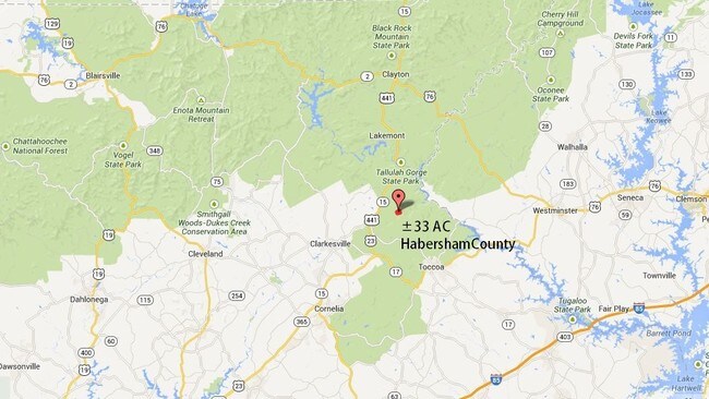
Property Record
Camp Yonah Rd, , GA


Property Detail
Camp Yonah Rd
153-011
12-179 PB 29-17 R/S-55-2 DB 1147-971
Privatepreserveopenspacevacantlandforestlandconservation
HABERSHAM
LI
Georgia
B and X Area of moderate flood hazard, usually the area between the limits of the 100-year and 500-year floods.
33.85 AC
2025
Georgia Northeast
2025
Other Market Areas
000100
Cornelia, GA
NEARBY LISTINGS FOR SALE OR LEASE
-
-
View all listings for sale on LoopNet.com
DEMOGRAPHICS near Camp Yonah Rd
1 mile
3 mile
5 mile
2025 Total Population
23
958
4,718
2030 Population
25
1,010
5,016
Pop Growth 2025-2030
+ 8.70%
+ 5.43%
+ 6.32%
Average Age
47
45
45
2025 Total Households
9
373
1,809
HH Growth 2025-2030
+ 11.11%
+ 5.63%
+ 6.36%
Median Household Inc
$59,999
$83,238
$82,509
Avg Household Size
2.10
2.50
2.50
2025 Avg HH Vehicles
3.00
2.00
3.00
Median Home Value
$450,000
$337,255
$303,617
Median Year Built
1991
1990
1990
Nearby Places
Map Layers
Map Styles
 Street
 Aerial
Transit
 Traffic
 Biking
Places
Listings with unknown addresses are not visible on the map
- Restaurants
- Banks
- Shops
- Fitness
- Groceries
SALE & LEASE HISTORY
LISTING DATE
SALE/LEASE

Aug 24, 2017
For Sale
Nearby Properties
Address
Land Use
TOTAL SIZE
Lot Size
Zoning
Address
Land Use
TOTAL SIZE
Lot Size
Zoning
1,100 AC
LI
Address
Land Use
TOTAL SIZE
Lot Size
Zoning
935 AC
LI
Address
Land Use
TOTAL SIZE
Lot Size
Zoning
874 AC
LI
Address
Land Use
TOTAL SIZE
Lot Size
Zoning
39,779 SF
16.48 AC
HI
Address
Land Use
TOTAL SIZE
Lot Size
Zoning
578 AC
LI
Address
Land Use
TOTAL SIZE
Lot Size
Zoning
420 AC
LI
Address
Land Use
TOTAL SIZE
Lot Size
Zoning
262 AC
LI
Address
Land Use
TOTAL SIZE
Lot Size
Zoning
242.66 AC
LI
Address
Land Use
TOTAL SIZE
Lot Size
Zoning
218.40 AC
LI
Address
Land Use
TOTAL SIZE
Lot Size
Zoning
188 AC
LI
Address
Land Use
TOTAL SIZE
Lot Size
Zoning
156.89 AC
AGRI
Address
Land Use
TOTAL SIZE
Lot Size
Zoning
143.15 AC
LI
Address
Land Use
TOTAL SIZE
Lot Size
Zoning
120.73 AC
LI
Address
Land Use
TOTAL SIZE
Lot Size
Zoning
6,932 SF
12.50 AC
LI
Address
Land Use
TOTAL SIZE
Lot Size
Zoning
8,100 SF
1.08 AC
LI
Address
Land Use
TOTAL SIZE
Lot Size
Zoning
3,522 SF
97.27 AC
LI
Address
Land Use
TOTAL SIZE
Lot Size
Zoning
5,419 SF
3.10 AC
HI
Address
Land Use
TOTAL SIZE
Lot Size
Zoning
149.70 AC
LI
Address
Land Use
TOTAL SIZE
Lot Size
Zoning
5,500 SF
4.62 AC
HI
Address
Land Use
TOTAL SIZE
Lot Size
Zoning
9,634 SF
1.33 AC
HI
Address
Land Use
TOTAL SIZE
Lot Size
Zoning
103.26 AC
LI
Address
Land Use
TOTAL SIZE
Lot Size
Zoning
Address
Land Use
TOTAL SIZE
Lot Size
Zoning
3,099 SF
1.93 AC
HI
Address
Land Use
TOTAL SIZE
Lot Size
Zoning
6,102 SF
7 AC
CG
Address
Land Use
TOTAL SIZE
Lot Size
Zoning
31.65 AC
AGRI
Address
Land Use
TOTAL SIZE
Lot Size
Zoning
48.47 AC
AGRI
Address
Land Use
TOTAL SIZE
Lot Size
Zoning
55.58 AC
LI
Address
Land Use
TOTAL SIZE
Lot Size
Zoning
4,816 SF
1 AC
LI
Address
Land Use
TOTAL SIZE
Lot Size
Zoning
55 AC
LI
Address
Land Use
TOTAL SIZE
Lot Size
Zoning
38.80 AC
LI
The World's #1 Commercial Real Estate Marketplace
Connect with us
© 2026 CoStar Group
The information above has been obtained from sources believed reliable. While we do not doubt its accuracy we have not verified it and make no guarantee, warranty or representation about it. It is your responsibility to independently confirm its accuracy and completeness. Any projections, opinions, assumptions, or estimates used are for example only and do not represent the current or future performance of the property. The value of this transaction to you depends on tax and other factors which should be evaluated by your tax, financial, and legal advisors. You and your advisors should conduct a careful, independent investigation of the property to determine to your satisfaction the suitability of the property for your needs.