Property Record
Cane Slash Rd, Johns Island, SC 29455

Property Detail
Cane Slash Rd
Charleston-North Charleston, SC
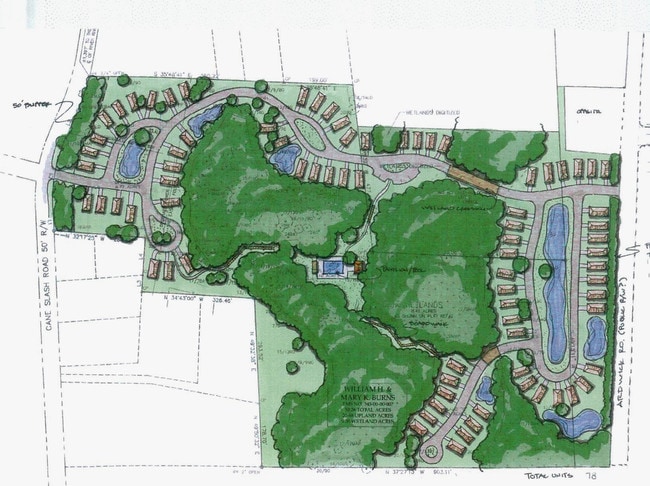
SITE NAME -SE SIDE APPROX 1370 FT SW RIVER RD
345-00-00-007
CHARLESTON
Residentialacreage
South Carolina
C and X Area of minimal flood hazard, usually depicted on FIRMs as above the 500-year flood level.
22.52 AC
2025
West Islands
2024
Charleston/N Charleston
002103
NEARBY LISTINGS FOR SALE OR LEASE
DEMOGRAPHICS near Cane Slash Rd
1 mile
3 mile
5 mile
2025 Total Population
3,898
17,223
66,171
2030 Population
4,100
18,032
68,741
Pop Growth 2025-2030
+ 5.18%
+ 4.70%
+ 3.88%
Average Age
39
40
41
2025 Total Households
1,626
7,180
29,942
HH Growth 2025-2030
+ 5.17%
+ 4.72%
+ 3.91%
Median Household Inc
$106,192
$114,670
$98,152
Avg Household Size
2.40
2.30
2.20
2025 Avg HH Vehicles
2.00
2.00
2.00
Median Home Value
$499,999
$471,164
$452,077
Median Year Built
2010
2008
1986
Nearby Places
Map Layers
Map Styles
 Street
 Aerial
Transit
 Traffic
 Biking
Places
Listings with unknown addresses are not visible on the map
- Restaurants
- Banks
- Shops
- Fitness
- Groceries
PUBLIC TRANSPORTATION
AIRPORT
Charleston AFB/International
Drive
Walk
Distance
Charleston AFB/International
34 min
19.6 mi
Freight Ports
Columbus Street Terminal
Drive
Walk
Distance
Columbus Street Terminal
18 min
8.8 mi
Nearby Properties
Address
Land Use
TOTAL SIZE
Lot Size
Zoning
Address
Land Use
TOTAL SIZE
Lot Size
Zoning
2,901 SF
4.76 AC
Address
Land Use
TOTAL SIZE
Lot Size
Zoning
55.08 AC
Address
Land Use
TOTAL SIZE
Lot Size
Zoning
119.64 AC
Address
Land Use
TOTAL SIZE
Lot Size
Zoning
10,176 SF
3.02 AC
Address
Land Use
TOTAL SIZE
Lot Size
Zoning
11,625 SF
9.17 AC
Address
Land Use
TOTAL SIZE
Lot Size
Zoning
21,612 SF
14.90 AC
Address
Land Use
TOTAL SIZE
Lot Size
Zoning
1.11 AC
Address
Land Use
TOTAL SIZE
Lot Size
Zoning
9.35 AC
Address
Land Use
TOTAL SIZE
Lot Size
Zoning
960 SF
1.15 AC
Address
Land Use
TOTAL SIZE
Lot Size
Zoning
301.64 AC
Address
Land Use
TOTAL SIZE
Lot Size
Zoning
2,024 SF
Address
Land Use
TOTAL SIZE
Lot Size
Zoning
Address
Land Use
TOTAL SIZE
Lot Size
Zoning
950 SF
10.11 AC
Address
Land Use
TOTAL SIZE
Lot Size
Zoning
21,612 SF
4 AC
Address
Land Use
TOTAL SIZE
Lot Size
Zoning
11,270 SF
1.16 AC
Address
Land Use
TOTAL SIZE
Lot Size
Zoning
943 SF
2.81 AC
Address
Land Use
TOTAL SIZE
Lot Size
Zoning
Address
Land Use
TOTAL SIZE
Lot Size
Zoning
32.40 AC
Address
Land Use
TOTAL SIZE
Lot Size
Zoning
5,760 SF
63.40 AC
Address
Land Use
TOTAL SIZE
Lot Size
Zoning
2,815 SF
5.75 AC
Address
Land Use
TOTAL SIZE
Lot Size
Zoning
60,592 SF
9.73 AC
Address
Land Use
TOTAL SIZE
Lot Size
Zoning
Address
Land Use
TOTAL SIZE
Lot Size
Zoning
Address
Land Use
TOTAL SIZE
Lot Size
Zoning
900 SF
3.23 AC
Address
Land Use
TOTAL SIZE
Lot Size
Zoning
Address
Land Use
TOTAL SIZE
Lot Size
Zoning
37,926 SF
7.50 AC
Address
Land Use
TOTAL SIZE
Lot Size
Zoning
Address
Land Use
TOTAL SIZE
Lot Size
Zoning
1,584 SF
2.50 AC
Address
Land Use
TOTAL SIZE
Lot Size
Zoning
Address
Land Use
TOTAL SIZE
Lot Size
Zoning
13.71 AC
The World's #1 Commercial Real Estate Marketplace
Connect with us
© 2026 CoStar Group
The information above has been obtained from sources believed reliable. While we do not doubt its accuracy we have not verified it and make no guarantee, warranty or representation about it. It is your responsibility to independently confirm its accuracy and completeness. Any projections, opinions, assumptions, or estimates used are for example only and do not represent the current or future performance of the property. The value of this transaction to you depends on tax and other factors which should be evaluated by your tax, financial, and legal advisors. You and your advisors should conduct a careful, independent investigation of the property to determine to your satisfaction the suitability of the property for your needs.