Property Record
Capital Dr, Carthage, NC 28327

Property Detail
Capital Dr
Pinehurst-Southern Pines, NC
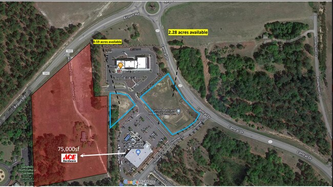
LOT 9 SOUTHERN PINES MUNI CAPITAL
20190158
MOORE
Commercialacreage
North Carolina
B and X Area of moderate flood hazard, usually the area between the limits of the 100-year and 500-year floods.
9
2025
0.69 AC
2025
North Carolina Southeast Area
950403
Other Market Areas
NEARBY LISTINGS FOR SALE OR LEASE
DEMOGRAPHICS near Capital Dr
1 mile
3 mile
5 mile
2025 Total Population
1,142
17,909
42,183
2030 Population
1,219
19,103
44,941
Pop Growth 2025-2030
+ 6.74%
+ 6.67%
+ 6.54%
Average Age
47
45
44
2025 Total Households
541
7,753
18,771
HH Growth 2025-2030
+ 6.84%
+ 6.91%
+ 6.79%
Median Household Inc
$97,473
$98,695
$86,504
Avg Household Size
2.10
2.30
2.20
2025 Avg HH Vehicles
2.00
2.00
2.00
Median Home Value
$461,983
$475,950
$450,972
Median Year Built
1998
1999
1995
Nearby Places
Map Layers
Map Styles
 Street
 Aerial
Transit
 Traffic
 Biking
Places
Listings with unknown addresses are not visible on the map
- Restaurants
- Banks
- Shops
- Fitness
- Groceries
PUBLIC TRANSPORTATION
AIRPORT
Fayetteville Regional/Grannis Field
Drive
Walk
Distance
Fayetteville Regional/Grannis Field
69 min
45.3 mi
SALE & LEASE HISTORY
LISTING DATE
SALE/LEASE

Jun 15, 2023
For Sale
Nearby Properties
Address
Land Use
TOTAL SIZE
Lot Size
Zoning
Address
Land Use
TOTAL SIZE
Lot Size
Zoning
30,190 SF
181.04 AC
PPC
Address
Land Use
TOTAL SIZE
Lot Size
Zoning
39.86 AC
Address
Land Use
TOTAL SIZE
Lot Size
Zoning
24,942 SF
39.99 AC
MULTI
Address
Land Use
TOTAL SIZE
Lot Size
Zoning
15,900 SF
179.30 AC
MULTI
Address
Land Use
TOTAL SIZE
Lot Size
Zoning
11.17 AC
Address
Land Use
TOTAL SIZE
Lot Size
Zoning
15,422 SF
35.21 AC
R20
Address
Land Use
TOTAL SIZE
Lot Size
Zoning
7,200 SF
486.56 AC
RS3
Address
Land Use
TOTAL SIZE
Lot Size
Zoning
8,118 SF
16.80 AC
PPC
Address
Land Use
TOTAL SIZE
Lot Size
Zoning
98,272 SF
25 AC
I
Address
Land Use
TOTAL SIZE
Lot Size
Zoning
53,926 SF
21.69 AC
GB
Address
Land Use
TOTAL SIZE
Lot Size
Zoning
15,100 SF
11.47 AC
NC
Address
Land Use
TOTAL SIZE
Lot Size
Zoning
10,435 SF
11.26 AC
R20
Address
Land Use
TOTAL SIZE
Lot Size
Zoning
840 SF
63 AC
RA
Address
Land Use
TOTAL SIZE
Lot Size
Zoning
24,520 SF
94.90 AC
PPCC
Address
Land Use
TOTAL SIZE
Lot Size
Zoning
36 SF
181.27 AC
RD
Address
Land Use
TOTAL SIZE
Lot Size
Zoning
13,200 SF
2 AC
I
Address
Land Use
TOTAL SIZE
Lot Size
Zoning
572 SF
117 AC
MULTI
Address
Land Use
TOTAL SIZE
Lot Size
Zoning
12,045 SF
2 AC
RE
Address
Land Use
TOTAL SIZE
Lot Size
Zoning
10,204 SF
11.14 AC
R20
Address
Land Use
TOTAL SIZE
Lot Size
Zoning
2,540 SF
22.51 AC
PPC
Address
Land Use
TOTAL SIZE
Lot Size
Zoning
35,262 SF
11.38 AC
NSCD
Address
Land Use
TOTAL SIZE
Lot Size
Zoning
19,852 SF
11.38 AC
RS3
Address
Land Use
TOTAL SIZE
Lot Size
Zoning
Address
Land Use
TOTAL SIZE
Lot Size
Zoning
13,238 SF
213.52 AC
PPC
Address
Land Use
TOTAL SIZE
Lot Size
Zoning
6,868 SF
5.05 AC
Address
Land Use
TOTAL SIZE
Lot Size
Zoning
13,628 SF
4.15 AC
B2
Address
Land Use
TOTAL SIZE
Lot Size
Zoning
72 AC
AP
Address
Land Use
TOTAL SIZE
Lot Size
Zoning
0.30 AC
RS2
Address
Land Use
TOTAL SIZE
Lot Size
Zoning
21.69 AC
I
Address
Land Use
TOTAL SIZE
Lot Size
Zoning
20.81 AC
GB
The World's #1 Commercial Real Estate Marketplace
Connect with us
© 2026 CoStar Group
The information above has been obtained from sources believed reliable. While we do not doubt its accuracy we have not verified it and make no guarantee, warranty or representation about it. It is your responsibility to independently confirm its accuracy and completeness. Any projections, opinions, assumptions, or estimates used are for example only and do not represent the current or future performance of the property. The value of this transaction to you depends on tax and other factors which should be evaluated by your tax, financial, and legal advisors. You and your advisors should conduct a careful, independent investigation of the property to determine to your satisfaction the suitability of the property for your needs.