Property Record
Capitol Dr, Addison, IL 60101
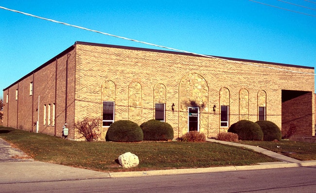
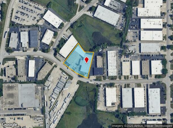
Property Detail
Capitol Dr
Chicago-Naperville-Elgin, IL-IN
Brunets Resub
03-30-404-037
BRUNETS RESUB ALL
Industrialgeneral
DuPage
X
Illinois
17043C0067J
1.42 AC
2024
West Suburbs
2024
Chicago
840303
NEARBY LISTINGS FOR SALE OR LEASE
DEMOGRAPHICS near Capitol Dr
1 mile
3 mile
5 mile
2024 Total Population
4,144
91,543
270,995
2029 Population
3,989
89,570
265,673
Pop Growth 2024-2029
(3.74%)
(2.16%)
(1.96%)
Average Age
43
40
40
2024 Total Households
1,554
32,882
98,692
HH Growth 2024-2029
(3.93%)
(2.24%)
(2.07%)
Median Household Inc
$74,706
$79,905
$90,917
Avg Household Size
2.60
2.70
2.70
2024 Avg HH Vehicles
2.00
2.00
2.00
Median Home Value
$295,286
$274,958
$318,386
Median Year Built
1971
1970
1971
Nearby Places
Map Layers
Map Styles
 Street
 Aerial
Transit
 Traffic
 Biking
Places
Listings with unknown addresses are not visible on the map
- Restaurants
- Banks
- Shops
- Fitness
- Groceries
PUBLIC TRANSPORTATION
COMMUTER RAIL
Lombard Station (Union Pacific West Line - Northeast Illinois Regional Commuter Railroad (Metra))
Drive
Walk
Distance
Lombard Station (Union Pacific West Line - Northeast Illinois Regional Commuter Railroad (Metra))
9 min
3.9 mi
Villa Park Station (Union Pacific West Line - Northeast Illinois Regional Commuter Railroad (Metra))
Drive
Walk
Distance
Villa Park Station (Union Pacific West Line - Northeast Illinois Regional Commuter Railroad (Metra))
12 min
4.2 mi
AIRPORT
Chicago O'Hare International
Drive
Walk
Distance
Chicago O'Hare International
26 min
14.7 mi
Chicago Midway International
Drive
Walk
Distance
Chicago Midway International
37 min
21.5 mi
Nearby Properties
Address
Land Use
TOTAL SIZE
Lot Size
Zoning
Address
Land Use
TOTAL SIZE
Lot Size
Zoning
693,153 SF
46.17 AC
Address
Land Use
TOTAL SIZE
Lot Size
Zoning
780,693 SF
42.30 AC
I
Address
Land Use
TOTAL SIZE
Lot Size
Zoning
16.91 AC
C
Address
Land Use
TOTAL SIZE
Lot Size
Zoning
102,314 SF
4.16 AC
R
Address
Land Use
TOTAL SIZE
Lot Size
Zoning
459,796 SF
18.15 AC
I
Address
Land Use
TOTAL SIZE
Lot Size
Zoning
309,864 SF
37.33 AC
I
Address
Land Use
TOTAL SIZE
Lot Size
Zoning
453,152 SF
20.35 AC
I
Address
Land Use
TOTAL SIZE
Lot Size
Zoning
136,975 SF
1.90 AC
Address
Land Use
TOTAL SIZE
Lot Size
Zoning
15.33 AC
M
Address
Land Use
TOTAL SIZE
Lot Size
Zoning
10.60 AC
Address
Land Use
TOTAL SIZE
Lot Size
Zoning
205,000 SF
16.78 AC
I
Address
Land Use
TOTAL SIZE
Lot Size
Zoning
175,260 SF
1.36 AC
R
Address
Land Use
TOTAL SIZE
Lot Size
Zoning
139,672 SF
15.41 AC
I
Address
Land Use
TOTAL SIZE
Lot Size
Zoning
4.08 AC
Address
Land Use
TOTAL SIZE
Lot Size
Zoning
286,305 SF
12.29 AC
I
Address
Land Use
TOTAL SIZE
Lot Size
Zoning
265,058 SF
15.05 AC
I
Address
Land Use
TOTAL SIZE
Lot Size
Zoning
211,392 SF
11.94 AC
R
Address
Land Use
TOTAL SIZE
Lot Size
Zoning
354,115 SF
24.95 AC
C
Address
Land Use
TOTAL SIZE
Lot Size
Zoning
209,184 SF
13.09 AC
I
Address
Land Use
TOTAL SIZE
Lot Size
Zoning
243,719 SF
12.07 AC
I
Address
Land Use
TOTAL SIZE
Lot Size
Zoning
237,520 SF
9.98 AC
I
Address
Land Use
TOTAL SIZE
Lot Size
Zoning
254,880 SF
12.59 AC
M
Address
Land Use
TOTAL SIZE
Lot Size
Zoning
257,335 SF
16.97 AC
I
Address
Land Use
TOTAL SIZE
Lot Size
Zoning
7.16 AC
I
Address
Land Use
TOTAL SIZE
Lot Size
Zoning
183,257 SF
12.66 AC
Address
Land Use
TOTAL SIZE
Lot Size
Zoning
258,333 SF
14.30 AC
I
Address
Land Use
TOTAL SIZE
Lot Size
Zoning
20,312 SF
3.53 AC
C
Address
Land Use
TOTAL SIZE
Lot Size
Zoning
185,898 SF
12.67 AC
Address
Land Use
TOTAL SIZE
Lot Size
Zoning
205,926 SF
8.06 AC
I
Address
Land Use
TOTAL SIZE
Lot Size
Zoning
194,253 SF
101.77 AC
C
The World's #1 Commercial Real Estate Marketplace
Connect with us
© 2026 CoStar Group
The information above has been obtained from sources believed reliable. While we do not doubt its accuracy we have not verified it and make no guarantee, warranty or representation about it. It is your responsibility to independently confirm its accuracy and completeness. Any projections, opinions, assumptions, or estimates used are for example only and do not represent the current or future performance of the property. The value of this transaction to you depends on tax and other factors which should be evaluated by your tax, financial, and legal advisors. You and your advisors should conduct a careful, independent investigation of the property to determine to your satisfaction the suitability of the property for your needs.