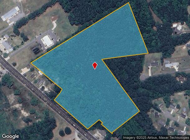
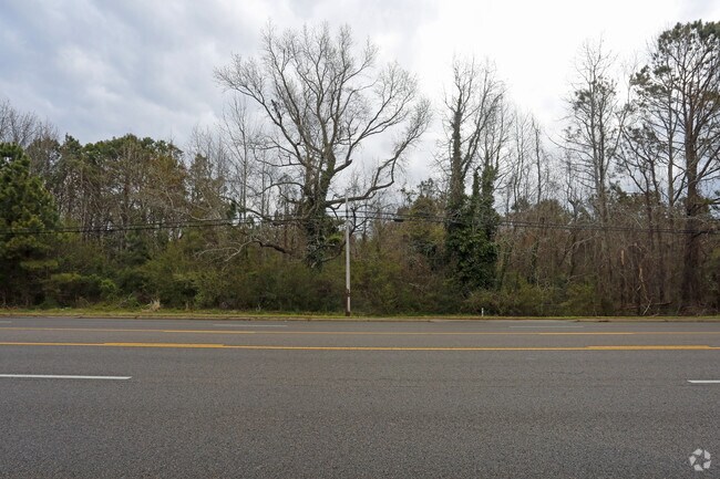
Property Record
Caratoke Hwy, Currituck, NC 27929

NEARBY LISTINGS FOR SALE OR LEASE
Property Detail
Caratoke Hwy
Virginia Beach-Norfolk-Newport News, VA-NC
PARCEL C GRANDY/HUTCHINSON SURVEY
0094-000-161C-0000
Currituck
Commercialacreage
North Carolina
X
161c
3720990200K
17.82 AC
2025
Currituck County
2025
Hampton Roads
110301
DEMOGRAPHICS near Caratoke Hwy
1 Mile
3 Mile
5 Mile
2024 Total Population
2,153
3,672
4,508
2029 Population
2,753
4,692
5,751
Pop Growth 2024-2029
+ 27.87%
+ 27.78%
+ 27.57%
Average Age
44
44
43
2024 Total Households
883
1,498
1,826
HH Growth 2024-2029
+ 27.97%
+ 27.84%
+ 27.66%
Median Household Inc
$68,893
$68,969
$69,173
Avg Household Size
2.40
2.40
2.50
2024 Avg HH Vehicles
2.00
2.00
2.00
Median Home Value
$240,636
$244,635
$249,363
Median Year Built
1991
1992
1992
Nearby Places
Map Layers
Map Styles
 Street
 Aerial
- Restaurants
- Banks
- Shops
- Fitness
- Groceries
SALE & LEASE HISTORY
LISTING DATE
SALE/LEASE

Apr 11, 2017
For Sale
Nearby Properties
Address
Land Use
TOTAL SIZE
Lot Size
Zoning
Address
Land Use
TOTAL SIZE
Lot Size
Zoning
81,355 SF
12 AC
SFM
Address
Land Use
TOTAL SIZE
Lot Size
Zoning
37,338 SF
5.48 AC
GB
Address
Land Use
TOTAL SIZE
Lot Size
Zoning
9,442 SF
3.80 AC
GB
Address
Land Use
TOTAL SIZE
Lot Size
Zoning
3,756 SF
3.58 AC
Address
Land Use
TOTAL SIZE
Lot Size
Zoning
13,272 SF
7.37 AC
GB
Address
Land Use
TOTAL SIZE
Lot Size
Zoning
3,704 SF
2.58 AC
GB
Address
Land Use
TOTAL SIZE
Lot Size
Zoning
0.35 AC
SFM
Address
Land Use
TOTAL SIZE
Lot Size
Zoning
2,930 SF
1.16 AC
GB
Address
Land Use
TOTAL SIZE
Lot Size
Zoning
3,080 SF
92.03 AC
AG
Address
Land Use
TOTAL SIZE
Lot Size
Zoning
1,600 SF
4.19 AC
GB
Address
Land Use
TOTAL SIZE
Lot Size
Zoning
1,542 SF
12.14 AC
GB
Address
Land Use
TOTAL SIZE
Lot Size
Zoning
13,588 SF
2.69 AC
GB
Address
Land Use
TOTAL SIZE
Lot Size
Zoning
11,064 SF
3.30 AC
SFM
Address
Land Use
TOTAL SIZE
Lot Size
Zoning
15,000 SF
7.50 AC
LI
Address
Land Use
TOTAL SIZE
Lot Size
Zoning
3,318 SF
2.57 AC
GB
Address
Land Use
TOTAL SIZE
Lot Size
Zoning
9,831 SF
1.85 AC
GB
Address
Land Use
TOTAL SIZE
Lot Size
Zoning
8,450 SF
9.09 AC
GB
Address
Land Use
TOTAL SIZE
Lot Size
Zoning
2,268 SF
4.15 AC
GB
Address
Land Use
TOTAL SIZE
Lot Size
Zoning
6,629 SF
3.08 AC
LB
Address
Land Use
TOTAL SIZE
Lot Size
Zoning
1,758 SF
1.89 AC
GB
Address
Land Use
TOTAL SIZE
Lot Size
Zoning
118.02 AC
GB
Address
Land Use
TOTAL SIZE
Lot Size
Zoning
24.75 AC
GB
Address
Land Use
TOTAL SIZE
Lot Size
Zoning
4,758 SF
1.31 AC
GB
Address
Land Use
TOTAL SIZE
Lot Size
Zoning
4,245 SF
0.47 AC
AG
Address
Land Use
TOTAL SIZE
Lot Size
Zoning
38.88 AC
GB
Address
Land Use
TOTAL SIZE
Lot Size
Zoning
6,141 SF
1.91 AC
GB
Address
Land Use
TOTAL SIZE
Lot Size
Zoning
600 SF
24.87 AC
GB
Address
Land Use
TOTAL SIZE
Lot Size
Zoning
2,257 SF
41.37 AC
AG
Address
Land Use
TOTAL SIZE
Lot Size
Zoning
2,800 SF
1.85 AC
SFM
Address
Land Use
TOTAL SIZE
Lot Size
Zoning
3,115 SF
3.12 AC
AG
The World's #1 Commercial Real Estate Marketplace
Connect with us
© 2025 CoStar Group
The information above has been obtained from sources believed reliable. While we do not doubt its accuracy we have not verified it and make no guarantee, warranty or representation about it. It is your responsibility to independently confirm its accuracy and completeness. Any projections, opinions, assumptions, or estimates used are for example only and do not represent the current or future performance of the property. The value of this transaction to you depends on tax and other factors which should be evaluated by your tax, financial, and legal advisors. You and your advisors should conduct a careful, independent investigation of the property to determine to your satisfaction the suitability of the property for your needs.