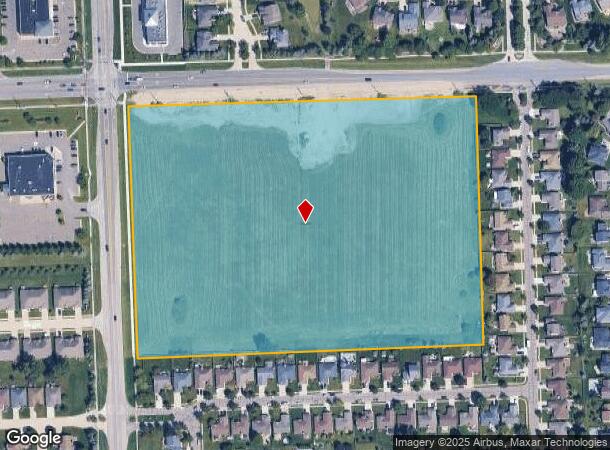
Property Record
Card Rd, Macomb, MI 48044

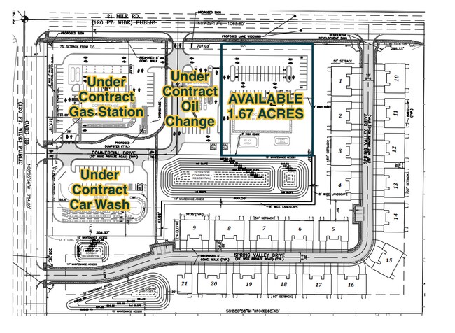
Current Lease Availabilities
Property Detail
Card Rd
20-08-35-100-004
T3N R13E SEC 35 BEG AT NW COR SEC 35; TH S89*34' E 1063.60 FT ALG N SEC LINE; TH S0*18' W 774.83 FT; TH S89*56'20" W 1060.48
Commercialacreage
Macomb
X
Michigan
26099C0244G
16.54 AC
2025
Macomb East
2025
Detroit
224102
Detroit-Warren-Dearborn, MI
NEARBY LISTINGS FOR SALE OR LEASE
DEMOGRAPHICS near Card Rd
1 mile
3 mile
5 mile
2024 Total Population
13,207
84,837
195,225
2029 Population
13,086
83,951
193,420
Pop Growth 2024-2029
(0.92%)
(1.04%)
(0.92%)
Average Age
37
39
42
2024 Total Households
4,475
31,380
78,303
HH Growth 2024-2029
(0.83%)
(1.03%)
(0.92%)
Median Household Inc
$92,111
$89,470
$78,627
Avg Household Size
2.90
2.60
2.40
2024 Avg HH Vehicles
2.00
2.00
2.00
Median Home Value
$288,888
$286,121
$262,491
Median Year Built
2002
1995
1991
Nearby Places
Map Layers
Map Styles
 Street
 Aerial
Transit
 Traffic
 Biking
Places
Listings with unknown addresses are not visible on the map
- Restaurants
- Banks
- Shops
- Fitness
- Groceries
PUBLIC TRANSPORTATION
AIRPORT
Windsor International
Drive
Walk
Distance
Windsor International
63 min
40.0 mi
Freight Ports
Port of Toledo
Drive
Walk
Distance
Port of Toledo
112 min
90.3 mi
Nearby Properties
Address
Land Use
TOTAL SIZE
Lot Size
Zoning
Address
Land Use
TOTAL SIZE
Lot Size
Zoning
426,076 SF
42.79 AC
B-4
Address
Land Use
TOTAL SIZE
Lot Size
Zoning
122.50 AC
RML
Address
Land Use
TOTAL SIZE
Lot Size
Zoning
35 AC
RML
Address
Land Use
TOTAL SIZE
Lot Size
Zoning
20,891 SF
289.61 AC
R3
Address
Land Use
TOTAL SIZE
Lot Size
Zoning
401,014 SF
32.54 AC
RML
Address
Land Use
TOTAL SIZE
Lot Size
Zoning
404,160 SF
22.52 AC
I-1
Address
Land Use
TOTAL SIZE
Lot Size
Zoning
44.65 AC
RML
Address
Land Use
TOTAL SIZE
Lot Size
Zoning
25.14 AC
RML
Address
Land Use
TOTAL SIZE
Lot Size
Zoning
20.27 AC
RML
Address
Land Use
TOTAL SIZE
Lot Size
Zoning
118,343 SF
7.33 AC
R1
Address
Land Use
TOTAL SIZE
Lot Size
Zoning
26.92 AC
RML
Address
Land Use
TOTAL SIZE
Lot Size
Zoning
670,448 SF
37.23 AC
L-2
Address
Land Use
TOTAL SIZE
Lot Size
Zoning
196,459 SF
19.18 AC
I-1
Address
Land Use
TOTAL SIZE
Lot Size
Zoning
229,878 SF
19.93 AC
C4 MULT
Address
Land Use
TOTAL SIZE
Lot Size
Zoning
42,385 SF
25.55 AC
B-2
Address
Land Use
TOTAL SIZE
Lot Size
Zoning
37.44 AC
RML
Address
Land Use
TOTAL SIZE
Lot Size
Zoning
45,000 SF
7.58 AC
B-4
Address
Land Use
TOTAL SIZE
Lot Size
Zoning
72,572 SF
10 AC
B-3
Address
Land Use
TOTAL SIZE
Lot Size
Zoning
134,327 SF
10.02 AC
I-1
Address
Land Use
TOTAL SIZE
Lot Size
Zoning
175,143 SF
22.87 AC
B-4
Address
Land Use
TOTAL SIZE
Lot Size
Zoning
148,446 SF
10.01 AC
RMH
Address
Land Use
TOTAL SIZE
Lot Size
Zoning
600 SF
18.79 AC
R2L
Address
Land Use
TOTAL SIZE
Lot Size
Zoning
87.32 AC
MH
Address
Land Use
TOTAL SIZE
Lot Size
Zoning
115,349 SF
14.39 AC
C3
Address
Land Use
TOTAL SIZE
Lot Size
Zoning
8.31 AC
RML
Address
Land Use
TOTAL SIZE
Lot Size
Zoning
45,864 SF
4.60 AC
C2
Address
Land Use
TOTAL SIZE
Lot Size
Zoning
149,652 SF
8.04 AC
SP-1
Address
Land Use
TOTAL SIZE
Lot Size
Zoning
99,717 SF
2.14 AC
I-1
Address
Land Use
TOTAL SIZE
Lot Size
Zoning
322,418 SF
8.08 AC
MU
The World's #1 Commercial Real Estate Marketplace
Connect with us
© 2026 CoStar Group
The information above has been obtained from sources believed reliable. While we do not doubt its accuracy we have not verified it and make no guarantee, warranty or representation about it. It is your responsibility to independently confirm its accuracy and completeness. Any projections, opinions, assumptions, or estimates used are for example only and do not represent the current or future performance of the property. The value of this transaction to you depends on tax and other factors which should be evaluated by your tax, financial, and legal advisors. You and your advisors should conduct a careful, independent investigation of the property to determine to your satisfaction the suitability of the property for your needs.