Property Record
Cardinal Dr, Lexington, SC 29073
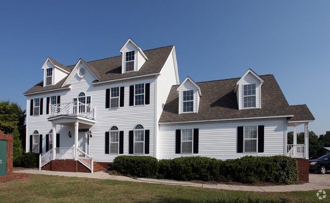

This Property Is For Sale
NEARBY LISTINGS FOR SALE OR LEASE
Property Detail
Cardinal Dr
005696-01-039
PARCEL B
Mobilemanufacturedhomeregardlessoflandownership
Lexington
X
South Carolina
45063C0257J
8.08 AC
2025
Cayce/West Columbia
2024
Columbia
021020
Columbia, SC
980 SF
DEMOGRAPHICS near Cardinal Dr
1 mile
3 mile
5 mile
2024 Total Population
4,328
35,420
97,921
2029 Population
4,729
38,460
106,516
Pop Growth 2024-2029
+ 9.27%
+ 8.58%
+ 8.78%
Average Age
40
40
40
2024 Total Households
1,769
14,341
41,034
HH Growth 2024-2029
+ 9.44%
+ 8.76%
+ 8.99%
Median Household Inc
$63,324
$65,968
$63,419
Avg Household Size
2.40
2.40
2.30
2024 Avg HH Vehicles
2.00
2.00
2.00
Median Home Value
$149,410
$162,359
$169,864
Median Year Built
1981
1989
1986
Nearby Places
Map Layers
Map Styles
 Street
 Aerial
Transit
 Traffic
 Biking
Places
Listings with unknown addresses are not visible on the map
- Restaurants
- Banks
- Shops
- Fitness
- Groceries
PUBLIC TRANSPORTATION
COMMUTER RAIL
Columbia Amtrak Station (Silver Star - Amtrak)
Drive
Walk
Distance
Columbia Amtrak Station (Silver Star - Amtrak)
13 min
7.6 mi
AIRPORT
Columbia Metro
Drive
Walk
Distance
Columbia Metro
19 min
7.5 mi
Freight Ports
North Charleston Terminal
Drive
Walk
Distance
North Charleston Terminal
120 min
105.4 mi
Nearby Properties
Address
Land Use
TOTAL SIZE
Lot Size
Zoning
Address
Land Use
TOTAL SIZE
Lot Size
Zoning
58,664 SF
6.01 AC
Address
Land Use
TOTAL SIZE
Lot Size
Zoning
461,888 SF
61.50 AC
ID
Address
Land Use
TOTAL SIZE
Lot Size
Zoning
222,557 SF
26.90 AC
ID
Address
Land Use
TOTAL SIZE
Lot Size
Zoning
58.81 AC
RD
Address
Land Use
TOTAL SIZE
Lot Size
Zoning
257,688 SF
23.03 AC
ID
Address
Land Use
TOTAL SIZE
Lot Size
Zoning
99,628 SF
13.09 AC
RD
Address
Land Use
TOTAL SIZE
Lot Size
Zoning
41,860 SF
6.54 AC
ID
Address
Land Use
TOTAL SIZE
Lot Size
Zoning
318,309 SF
33.51 AC
ID
Address
Land Use
TOTAL SIZE
Lot Size
Zoning
7,383 SF
4.85 AC
ID
Address
Land Use
TOTAL SIZE
Lot Size
Zoning
70,740 SF
13 AC
ID
Address
Land Use
TOTAL SIZE
Lot Size
Zoning
59.61 AC
ID
Address
Land Use
TOTAL SIZE
Lot Size
Zoning
126,000 SF
8.89 AC
Address
Land Use
TOTAL SIZE
Lot Size
Zoning
430.11 AC
ID
Address
Land Use
TOTAL SIZE
Lot Size
Zoning
3,825 SF
18.45 AC
RD
Address
Land Use
TOTAL SIZE
Lot Size
Zoning
79,951 SF
3.31 AC
RD
Address
Land Use
TOTAL SIZE
Lot Size
Zoning
39,700 SF
73.29 AC
ID
Address
Land Use
TOTAL SIZE
Lot Size
Zoning
66,043 SF
2.70 AC
ID
Address
Land Use
TOTAL SIZE
Lot Size
Zoning
86,711 SF
3.46 AC
ID
Address
Land Use
TOTAL SIZE
Lot Size
Zoning
54,000 SF
8.60 AC
ID
Address
Land Use
TOTAL SIZE
Lot Size
Zoning
147,166 SF
18.27 AC
ID
Address
Land Use
TOTAL SIZE
Lot Size
Zoning
33,268 SF
2.28 AC
ID
Address
Land Use
TOTAL SIZE
Lot Size
Zoning
8,269 SF
12.99 AC
RD
Address
Land Use
TOTAL SIZE
Lot Size
Zoning
14,169 SF
6.46 AC
ID
Address
Land Use
TOTAL SIZE
Lot Size
Zoning
44,958 SF
9 AC
C
Address
Land Use
TOTAL SIZE
Lot Size
Zoning
162,500 SF
12.36 AC
ID
Address
Land Use
TOTAL SIZE
Lot Size
Zoning
37,404 SF
9.32 AC
Address
Land Use
TOTAL SIZE
Lot Size
Zoning
10.52 AC
ID
Address
Land Use
TOTAL SIZE
Lot Size
Zoning
44,710 SF
4.26 AC
ID
Address
Land Use
TOTAL SIZE
Lot Size
Zoning
14,390 SF
6.86 AC
Address
Land Use
TOTAL SIZE
Lot Size
Zoning
115,000 SF
11.99 AC
ID
The World's #1 Commercial Real Estate Marketplace
Connect with us
© 2026 CoStar Group
The information above has been obtained from sources believed reliable. While we do not doubt its accuracy we have not verified it and make no guarantee, warranty or representation about it. It is your responsibility to independently confirm its accuracy and completeness. Any projections, opinions, assumptions, or estimates used are for example only and do not represent the current or future performance of the property. The value of this transaction to you depends on tax and other factors which should be evaluated by your tax, financial, and legal advisors. You and your advisors should conduct a careful, independent investigation of the property to determine to your satisfaction the suitability of the property for your needs.