Property Record
Cargill Rd, Kilgore, TX 75662
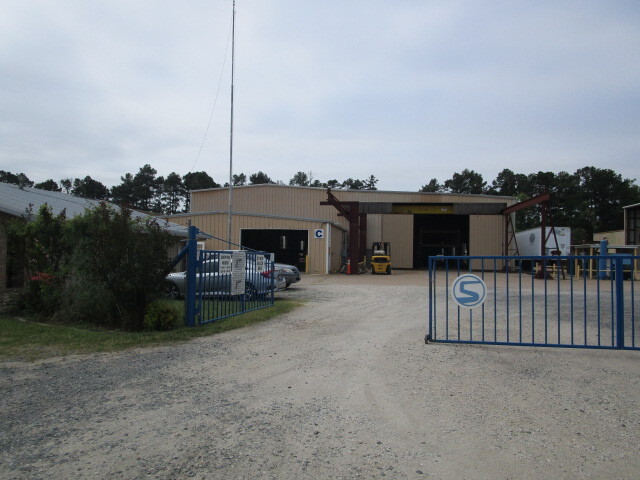
Property Detail
Cargill Rd
Longview, TX
AB 134 JOHN MOFFITT SUR TR 21
23593
GREGG
Commercialnec
Texas
B and X Area of moderate flood hazard, usually the area between the limits of the 100-year and 500-year floods.
21
2024
5.66 AC
2025
Longview
010401
Other Market Areas
2,400 SF
NEARBY LISTINGS FOR SALE OR LEASE
DEMOGRAPHICS near Cargill Rd
1 mile
3 mile
5 mile
2025 Total Population
385
4,269
18,336
2030 Population
396
4,404
18,788
Pop Growth 2025-2030
+ 2.86%
+ 3.16%
+ 2.47%
Average Age
37
37
38
2025 Total Households
138
1,581
6,755
HH Growth 2025-2030
+ 2.90%
+ 3.16%
+ 2.55%
Median Household Inc
$51,818
$55,425
$63,124
Avg Household Size
2.80
2.60
2.60
2025 Avg HH Vehicles
2.00
2.00
2.00
Median Home Value
$140,625
$123,721
$166,003
Median Year Built
1988
1981
1978
Nearby Places
Map Layers
Map Styles
 Street
 Aerial
Transit
 Traffic
 Biking
Places
Listings with unknown addresses are not visible on the map
- Restaurants
- Banks
- Shops
- Fitness
- Groceries
PUBLIC TRANSPORTATION
COMMUTER RAIL
Longview (Texas Eagle - Amtrak)
Drive
Walk
Distance
Longview (Texas Eagle - Amtrak)
13 min
9.4 mi
Freight Ports
Port of Shreveport
Drive
Walk
Distance
Port of Shreveport
90 min
77.9 mi
SALE & LEASE HISTORY
LISTING DATE
SALE/LEASE

Mar 16, 2021
For Sale
Mar 07, 2023
For Lease
Feb 11, 2022
For Sale
Nearby Properties
Address
Land Use
TOTAL SIZE
Lot Size
Zoning
Address
Land Use
TOTAL SIZE
Lot Size
Zoning
550,214 SF
67.40 AC
Address
Land Use
TOTAL SIZE
Lot Size
Zoning
140,050 SF
9.22 AC
Address
Land Use
TOTAL SIZE
Lot Size
Zoning
81,237 SF
21.09 AC
Address
Land Use
TOTAL SIZE
Lot Size
Zoning
171,388 SF
18.76 AC
Address
Land Use
TOTAL SIZE
Lot Size
Zoning
13,767 SF
29.06 AC
Address
Land Use
TOTAL SIZE
Lot Size
Zoning
90,000 SF
13.35 AC
Address
Land Use
TOTAL SIZE
Lot Size
Zoning
53,052 SF
9.02 AC
Address
Land Use
TOTAL SIZE
Lot Size
Zoning
118,324 SF
10 AC
Address
Land Use
TOTAL SIZE
Lot Size
Zoning
43,083 SF
2.81 AC
Address
Land Use
TOTAL SIZE
Lot Size
Zoning
46,368 SF
2 AC
Address
Land Use
TOTAL SIZE
Lot Size
Zoning
57,632 SF
8.72 AC
Address
Land Use
TOTAL SIZE
Lot Size
Zoning
4,600 SF
43.22 AC
Address
Land Use
TOTAL SIZE
Lot Size
Zoning
38,995 SF
2.46 AC
Address
Land Use
TOTAL SIZE
Lot Size
Zoning
79,590 SF
8.54 AC
Address
Land Use
TOTAL SIZE
Lot Size
Zoning
68,130 SF
12.55 AC
Address
Land Use
TOTAL SIZE
Lot Size
Zoning
43,200 SF
9.25 AC
Address
Land Use
TOTAL SIZE
Lot Size
Zoning
43,100 SF
7.92 AC
Address
Land Use
TOTAL SIZE
Lot Size
Zoning
462,237 SF
54.99 AC
Address
Land Use
TOTAL SIZE
Lot Size
Zoning
82,730 SF
7.50 AC
Address
Land Use
TOTAL SIZE
Lot Size
Zoning
36,400 SF
11.32 AC
Address
Land Use
TOTAL SIZE
Lot Size
Zoning
68,587 SF
11.74 AC
Address
Land Use
TOTAL SIZE
Lot Size
Zoning
8,736 SF
3.77 AC
Address
Land Use
TOTAL SIZE
Lot Size
Zoning
5,512 SF
245.88 AC
Address
Land Use
TOTAL SIZE
Lot Size
Zoning
40,860 SF
20.34 AC
C
Address
Land Use
TOTAL SIZE
Lot Size
Zoning
13,821 SF
9.74 AC
L
Address
Land Use
TOTAL SIZE
Lot Size
Zoning
7,736 SF
11.92 AC
Address
Land Use
TOTAL SIZE
Lot Size
Zoning
8.45 AC
D
Address
Land Use
TOTAL SIZE
Lot Size
Zoning
13,100 SF
12.22 AC
Address
Land Use
TOTAL SIZE
Lot Size
Zoning
45.40 AC
Address
Land Use
TOTAL SIZE
Lot Size
Zoning
37,200 SF
6.40 AC
The World's #1 Commercial Real Estate Marketplace
Connect with us
© 2026 CoStar Group
The information above has been obtained from sources believed reliable. While we do not doubt its accuracy we have not verified it and make no guarantee, warranty or representation about it. It is your responsibility to independently confirm its accuracy and completeness. Any projections, opinions, assumptions, or estimates used are for example only and do not represent the current or future performance of the property. The value of this transaction to you depends on tax and other factors which should be evaluated by your tax, financial, and legal advisors. You and your advisors should conduct a careful, independent investigation of the property to determine to your satisfaction the suitability of the property for your needs.