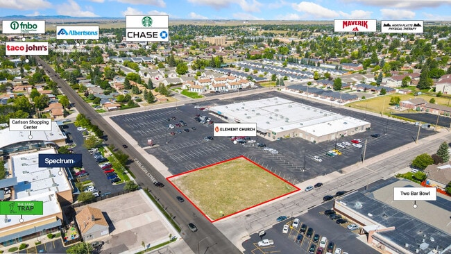
Property Record
Carlson St, Cheyenne, WY

Save to a Folder
{{folder.Name}}
{{folder.ListingIds.length}} Properties
{{folder.ListingIds.length}} Property
Create a New Folder
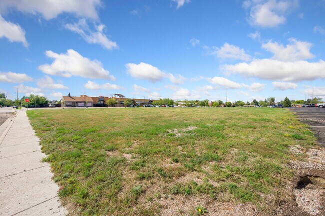
Property Detail
Carlson St
Cheyenne, WY
AIRPORT VALLEY TRACTS: PARCEL 150 X 150 IN SOUTHEAST COR TRACT 20
1-1028-0020-0001-1
LARAMIE
Commercialacreage
Wyoming
MUB
1-1
B and X Area of moderate flood hazard, usually the area between the limits of the 100-year and 500-year floods.
0.52 AC
2025
I-80 Corridor/Cheyenne
2026
Other Market Areas
001901
NEARBY LISTINGS FOR SALE OR LEASE
DEMOGRAPHICS near Carlson St
1 mile
3 mile
5 mile
2025 Total Population
8,012
42,323
80,018
2030 Population
7,953
42,731
80,739
Pop Growth 2025-2030
(0.74%)
+ 0.96%
+ 0.90%
Average Age
44
42
40
2025 Total Households
3,627
18,283
33,777
HH Growth 2025-2030
(0.61%)
+ 0.90%
+ 0.95%
Median Household Inc
$81,490
$80,596
$73,583
Avg Household Size
2.20
2.20
2.30
2025 Avg HH Vehicles
2.00
2.00
2.00
Median Home Value
$354,528
$357,451
$328,923
Median Year Built
1981
1973
1978
Nearby Places
Map Layers
Map Styles
 Street
 Aerial
Layers
 Traffic
 Biking
Places
Listings with unknown addresses are not visible on the map
- Restaurants
- Banks
- Shops
- Fitness
- Groceries
Nearby Properties
Address
Land Use
TOTAL SIZE
Lot Size
Zoning
Address
Land Use
TOTAL SIZE
Lot Size
Zoning
265,882 SF
12.16 AC
Address
Land Use
TOTAL SIZE
Lot Size
Zoning
Address
Land Use
TOTAL SIZE
Lot Size
Zoning
91,021 SF
7.40 AC
Address
Land Use
TOTAL SIZE
Lot Size
Zoning
148,018 SF
Address
Land Use
TOTAL SIZE
Lot Size
Zoning
210,717 SF
18.28 AC
Address
Land Use
TOTAL SIZE
Lot Size
Zoning
219,227 SF
21.97 AC
CB
Address
Land Use
TOTAL SIZE
Lot Size
Zoning
69,726 SF
0.80 AC
CBD
Address
Land Use
TOTAL SIZE
Lot Size
Zoning
118,588 SF
3.20 AC
CB
Address
Land Use
TOTAL SIZE
Lot Size
Zoning
109,744 SF
7.04 AC
Address
Land Use
TOTAL SIZE
Lot Size
Zoning
227,850 SF
6.88 AC
HR1
Address
Land Use
TOTAL SIZE
Lot Size
Zoning
76,524 SF
6 AC
Address
Land Use
TOTAL SIZE
Lot Size
Zoning
132,839 SF
6.38 AC
Address
Land Use
TOTAL SIZE
Lot Size
Zoning
85,314 SF
5.50 AC
P
Address
Land Use
TOTAL SIZE
Lot Size
Zoning
142,588 SF
3.54 AC
PUD
Address
Land Use
TOTAL SIZE
Lot Size
Zoning
81,948 SF
9.39 AC
CB
Address
Land Use
TOTAL SIZE
Lot Size
Zoning
86,860 SF
1.70 AC
CB
Address
Land Use
TOTAL SIZE
Lot Size
Zoning
88,107 SF
10.73 AC
Address
Land Use
TOTAL SIZE
Lot Size
Zoning
59,325 SF
0.85 AC
CBD
Address
Land Use
TOTAL SIZE
Lot Size
Zoning
108,332 SF
0.80 AC
MUB
Address
Land Use
TOTAL SIZE
Lot Size
Zoning
79,186 SF
3.09 AC
Address
Land Use
TOTAL SIZE
Lot Size
Zoning
67,628 SF
2.23 AC
Address
Land Use
TOTAL SIZE
Lot Size
Zoning
148,152 SF
15.54 AC
CB
Address
Land Use
TOTAL SIZE
Lot Size
Zoning
70,251 SF
0.77 AC
Address
Land Use
TOTAL SIZE
Lot Size
Zoning
137,640 SF
14.43 AC
CB
Address
Land Use
TOTAL SIZE
Lot Size
Zoning
83,059 SF
8.88 AC
CB
Address
Land Use
TOTAL SIZE
Lot Size
Zoning
323,835 SF
Address
Land Use
TOTAL SIZE
Lot Size
Zoning
Address
Land Use
TOTAL SIZE
Lot Size
Zoning
66,099 SF
4.46 AC
PUD
Address
Land Use
TOTAL SIZE
Lot Size
Zoning
25,369 SF
1.64 AC
PUD
Address
Land Use
TOTAL SIZE
Lot Size
Zoning
28,809 SF
8.45 AC
The World's #1 Commercial Real Estate Marketplace
Connect with us
© 2026 CoStar Group
The information above has been obtained from sources believed reliable. While we do not doubt its accuracy we have not verified it and make no guarantee, warranty or representation about it. It is your responsibility to independently confirm its accuracy and completeness. Any projections, opinions, assumptions, or estimates used are for example only and do not represent the current or future performance of the property. The value of this transaction to you depends on tax and other factors which should be evaluated by your tax, financial, and legal advisors. You and your advisors should conduct a careful, independent investigation of the property to determine to your satisfaction the suitability of the property for your needs.