Property Record
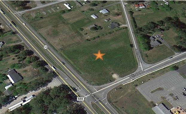
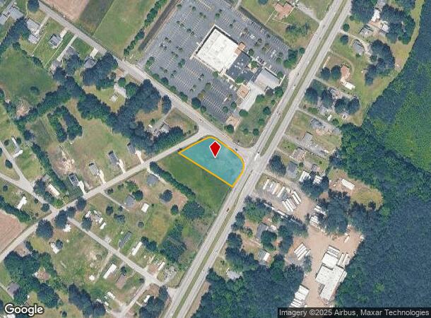
Carolina Rd, Suffolk, VA 23434
NEARBY LISTINGS FOR SALE OR LEASE
Property Detail
Carolina Rd
100538700
HWY 32,RT 646,HINES
Commercialacreage
Suffolk City
X
Virginia
5101560230E
0.82 AC
2025
South Suffolk
2024
Hampton Roads
065200
Virginia Beach-Norfolk-Newport News, VA-NC
DEMOGRAPHICS near Carolina Rd
1 Mile
3 Mile
5 Mile
2024 Total Population
599
15,824
33,256
2029 Population
679
17,674
37,151
Pop Growth 2024-2029
+ 13.36%
+ 11.69%
+ 11.71%
Average Age
44
38
39
2024 Total Households
249
6,339
12,999
HH Growth 2024-2029
+ 13.25%
+ 12.04%
+ 12.05%
Median Household Inc
$69,193
$56,642
$58,744
Avg Household Size
2.30
2.40
2.50
2024 Avg HH Vehicles
3.00
2.00
2.00
Median Home Value
$233,721
$241,379
$245,773
Median Year Built
1984
1971
1974
Nearby Places
Map Layers
Map Styles
 Street
 Aerial
- Restaurants
- Banks
- Shops
- Fitness
- Groceries
PUBLIC TRANSPORTATION
AIRPORT
Norfolk International
DRIVE
WALK
Distance
Norfolk International
46 min
29.3 mi
Freight Ports
Virginia Port Authority - Portsmouth
DRIVE
WALK
Distance
Virginia Port Authority - Portsmouth
35 min
22.2 mi
SALE & LEASE HISTORY
LISTING DATE
SALE/LEASE

Sep 24, 2016
For Sale
Nearby Properties
Address
Land Use
TOTAL SIZE
Lot Size
Zoning
Address
Land Use
TOTAL SIZE
Lot Size
Zoning
71.72 AC
HEAVY INDU
Address
Land Use
TOTAL SIZE
Lot Size
Zoning
72.52 AC
LIGHT INDU
Address
Land Use
TOTAL SIZE
Lot Size
Zoning
10,255 SF
35.42 AC
HEAVY INDU
Address
Land Use
TOTAL SIZE
Lot Size
Zoning
12,296 SF
655 AC
HEAVY INDU
Address
Land Use
TOTAL SIZE
Lot Size
Zoning
91,512 SF
0.35 AC
CENTRAL BU
Address
Land Use
TOTAL SIZE
Lot Size
Zoning
115,088 SF
0.17 AC
CENTRAL BU
Address
Land Use
TOTAL SIZE
Lot Size
Zoning
9,800 SF
8.22 AC
HEAVY INDU
Address
Land Use
TOTAL SIZE
Lot Size
Zoning
4.70 AC
RESIDENTIA
Address
Land Use
TOTAL SIZE
Lot Size
Zoning
101,502 SF
15.83 AC
RES LOW-ME
Address
Land Use
TOTAL SIZE
Lot Size
Zoning
62,037 SF
6.66 AC
FAIRGROUND
Address
Land Use
TOTAL SIZE
Lot Size
Zoning
209.55 AC
HEAVY INDU
Address
Land Use
TOTAL SIZE
Lot Size
Zoning
58,439 SF
15.27 AC
RES LOW-ME
Address
Land Use
TOTAL SIZE
Lot Size
Zoning
12,927 SF
2.67 AC
RESIDENTIA
Address
Land Use
TOTAL SIZE
Lot Size
Zoning
49,200 SF
18.51 AC
HEAVY INDU
Address
Land Use
TOTAL SIZE
Lot Size
Zoning
25,000 SF
13.90 AC
LIGHT INDU
Address
Land Use
TOTAL SIZE
Lot Size
Zoning
57,600 SF
7.83 AC
HEAVY INDU
Address
Land Use
TOTAL SIZE
Lot Size
Zoning
86,213 SF
61.69 AC
RES LOW-ME
Address
Land Use
TOTAL SIZE
Lot Size
Zoning
1,800 SF
905.32 AC
CONSERVATI
Address
Land Use
TOTAL SIZE
Lot Size
Zoning
14,635 SF
2.58 AC
GENERAL CO
Address
Land Use
TOTAL SIZE
Lot Size
Zoning
28,800 SF
4.75 AC
GENERAL CO
Address
Land Use
TOTAL SIZE
Lot Size
Zoning
49,020 SF
37.44 AC
RESIDENTIA
Address
Land Use
TOTAL SIZE
Lot Size
Zoning
40,656 SF
4.42 AC
OFFICE-INS
Address
Land Use
TOTAL SIZE
Lot Size
Zoning
39,000 SF
3.89 AC
HEAVY INDU
Address
Land Use
TOTAL SIZE
Lot Size
Zoning
20,520 SF
9.22 AC
GENERAL CO
Address
Land Use
TOTAL SIZE
Lot Size
Zoning
10,500 SF
0.13 AC
FAIRGROUND
Address
Land Use
TOTAL SIZE
Lot Size
Zoning
88,625 SF
9.50 AC
HEAVY INDU
Address
Land Use
TOTAL SIZE
Lot Size
Zoning
78,405 SF
6.77 AC
HEAVY INDU
The World's #1 Commercial Real Estate Marketplace
Connect with us
© 2025 CoStar Group
The information above has been obtained from sources believed reliable. While we do not doubt its accuracy we have not verified it and make no guarantee, warranty or representation about it. It is your responsibility to independently confirm its accuracy and completeness. Any projections, opinions, assumptions, or estimates used are for example only and do not represent the current or future performance of the property. The value of this transaction to you depends on tax and other factors which should be evaluated by your tax, financial, and legal advisors. You and your advisors should conduct a careful, independent investigation of the property to determine to your satisfaction the suitability of the property for your needs.