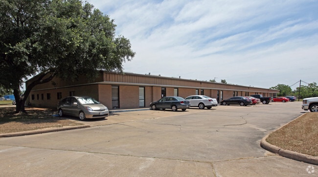
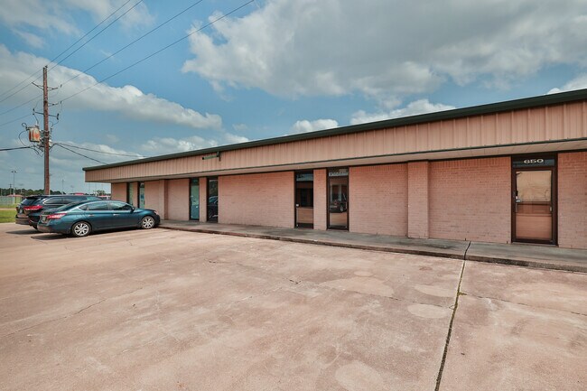
Property Record
6819 Highway Blvd, Katy, TX 77494

Property Detail
6819 Highway Blvd
Houston-Pasadena-The Woodlands, TX
WINCHESTER BUSINESS PARK SEC 1, BLOCK 1, LOT 6, ACRES 2.7237
8946-01-001-0060-914
FORT BEND
Commercialnec
Texas
B and X Area of moderate flood hazard, usually the area between the limits of the 100-year and 500-year floods.
6
2024
2.72 AC
2025
Katy/Grand Parkway West
680100
Houston
31,407 SF
NEARBY LISTINGS FOR SALE OR LEASE
DEMOGRAPHICS near 6819 Highway Blvd
1 mile
3 mile
5 mile
2025 Total Population
2,494
66,892
217,146
2030 Population
2,818
74,965
243,988
Pop Growth 2025-2030
+ 12.99%
+ 12.07%
+ 12.36%
Average Age
37
36
36
2025 Total Households
792
21,583
69,231
HH Growth 2025-2030
+ 13.38%
+ 12.27%
+ 12.54%
Median Household Inc
$131,180
$124,716
$126,604
Avg Household Size
3.10
3.10
3.10
2025 Avg HH Vehicles
2.00
2.00
2.00
Median Home Value
$426,234
$453,160
$431,745
Median Year Built
2011
2010
2010
Nearby Places
Map Layers
Map Styles
 Street
 Aerial
Layers
 Traffic
 Biking
Places
Listings with unknown addresses are not visible on the map
- Restaurants
- Banks
- Shops
- Fitness
- Groceries
PUBLIC TRANSPORTATION
AIRPORT
William P Hobby
Drive
Walk
Distance
William P Hobby
61 min
42.4 mi
George Bush Intcntl/Houston
Drive
Walk
Distance
George Bush Intcntl/Houston
55 min
43.7 mi
Freight Ports
Port of Houston
Drive
Walk
Distance
Port of Houston
54 min
39.2 mi
SALE & LEASE HISTORY
LISTING DATE
SALE/LEASE

May 14, 2023
For Lease
Nearby Properties
Address
Land Use
TOTAL SIZE
Lot Size
Zoning
Address
Land Use
TOTAL SIZE
Lot Size
Zoning
1,655,920 SF
121.35 AC
Address
Land Use
TOTAL SIZE
Lot Size
Zoning
720,217 SF
65.17 AC
Address
Land Use
TOTAL SIZE
Lot Size
Zoning
1,300,000 SF
60.33 AC
Address
Land Use
TOTAL SIZE
Lot Size
Zoning
185,815 SF
30.28 AC
Address
Land Use
TOTAL SIZE
Lot Size
Zoning
Address
Land Use
TOTAL SIZE
Lot Size
Zoning
351,758 SF
18.23 AC
Address
Land Use
TOTAL SIZE
Lot Size
Zoning
363,173 SF
13.57 AC
Address
Land Use
TOTAL SIZE
Lot Size
Zoning
327,699 SF
11.64 AC
Address
Land Use
TOTAL SIZE
Lot Size
Zoning
6.13 AC
Address
Land Use
TOTAL SIZE
Lot Size
Zoning
12.50 AC
Address
Land Use
TOTAL SIZE
Lot Size
Zoning
261,803 SF
12.51 AC
Address
Land Use
TOTAL SIZE
Lot Size
Zoning
Address
Land Use
TOTAL SIZE
Lot Size
Zoning
329,094 SF
13.78 AC
Address
Land Use
TOTAL SIZE
Lot Size
Zoning
270,728 SF
9.45 AC
Address
Land Use
TOTAL SIZE
Lot Size
Zoning
678,028 SF
42.63 AC
Address
Land Use
TOTAL SIZE
Lot Size
Zoning
322,774 SF
9.19 AC
Address
Land Use
TOTAL SIZE
Lot Size
Zoning
620,415 SF
5.96 AC
Address
Land Use
TOTAL SIZE
Lot Size
Zoning
485,899 SF
5.96 AC
Address
Land Use
TOTAL SIZE
Lot Size
Zoning
148,600 SF
14.61 AC
Address
Land Use
TOTAL SIZE
Lot Size
Zoning
29.37 AC
Address
Land Use
TOTAL SIZE
Lot Size
Zoning
20.05 AC
SYQ
Address
Land Use
TOTAL SIZE
Lot Size
Zoning
285,065 SF
14.72 AC
Address
Land Use
TOTAL SIZE
Lot Size
Zoning
296,130 SF
12 AC
Address
Land Use
TOTAL SIZE
Lot Size
Zoning
51,600 SF
19.66 AC
Address
Land Use
TOTAL SIZE
Lot Size
Zoning
108,600 SF
9.08 AC
Address
Land Use
TOTAL SIZE
Lot Size
Zoning
510,614 SF
56.19 AC
Address
Land Use
TOTAL SIZE
Lot Size
Zoning
12.71 AC
Address
Land Use
TOTAL SIZE
Lot Size
Zoning
13.39 AC
Address
Land Use
TOTAL SIZE
Lot Size
Zoning
168,025 SF
13.55 AC
Address
Land Use
TOTAL SIZE
Lot Size
Zoning
226,076 SF
10.37 AC
The World's #1 Commercial Real Estate Marketplace
Connect with us
© 2026 CoStar Group
The information above has been obtained from sources believed reliable. While we do not doubt its accuracy we have not verified it and make no guarantee, warranty or representation about it. It is your responsibility to independently confirm its accuracy and completeness. Any projections, opinions, assumptions, or estimates used are for example only and do not represent the current or future performance of the property. The value of this transaction to you depends on tax and other factors which should be evaluated by your tax, financial, and legal advisors. You and your advisors should conduct a careful, independent investigation of the property to determine to your satisfaction the suitability of the property for your needs.