Property Record
Carroll Canyon Rd, San Diego, CA 92121


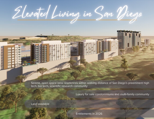
This Property Is For Sale
NEARBY LISTINGS FOR SALE OR LEASE
Property Detail
Carroll Canyon Rd
San Diego-Carlsbad, CA
Lusk Indust Park
343-010-52
LOT 75 (EX ST) TR 009694
Privatepreserveopenspacevacantlandforestlandconservation
San Diego
AE
California
06073C1339G
75
2024
33.83 AC
2025
Mira Mesa/Miramar
008346
San Diego
DEMOGRAPHICS near Carroll Canyon Rd
1 Mile
3 Mile
5 Mile
2024 Total Population
747
97,091
244,543
2029 Population
743
97,532
244,010
Pop Growth 2024-2029
(0.54%)
+ 0.45%
(0.22%)
Average Age
35
35
38
2024 Total Households
275
35,686
86,701
HH Growth 2024-2029
(1.09%)
+ 0.75%
(0.09%)
Median Household Inc
$125,278
$104,988
$115,547
Avg Household Size
2.60
2.30
2.50
2024 Avg HH Vehicles
2.00
2.00
2.00
Median Home Value
$755,050
$886,886
$869,230
Median Year Built
1994
1989
1983
Nearby Places
Map Layers
Map Styles
 Street
 Aerial
- Restaurants
- Banks
- Shops
- Fitness
- Groceries
PUBLIC TRANSPORTATION
COMMUTER RAIL
Sorrento Valley (Coaster - San Diego North County Transit District (Coaster/Sprinter/Breeze))
DRIVE
WALK
Distance
Sorrento Valley (Coaster - San Diego North County Transit District (Coaster/Sprinter/Breeze))
5 min
2.8 mi
Solana Beach (Coaster - San Diego North County Transit District (Coaster/Sprinter/Breeze))
DRIVE
WALK
Distance
Solana Beach (Coaster - San Diego North County Transit District (Coaster/Sprinter/Breeze))
13 min
9.9 mi
AIRPORT
San Diego International
DRIVE
WALK
Distance
San Diego International
22 min
14.1 mi
Freight Ports
Port of San Diego
DRIVE
WALK
Distance
Port of San Diego
25 min
16.3 mi
Nearby Properties
Address
Land Use
TOTAL SIZE
Lot Size
Zoning
Address
Land Use
TOTAL SIZE
Lot Size
Zoning
40.28 AC
CR-1-1
Address
Land Use
TOTAL SIZE
Lot Size
Zoning
28.94 AC
IL-2-1
Address
Land Use
TOTAL SIZE
Lot Size
Zoning
15.78 AC
IL-2-1
Address
Land Use
TOTAL SIZE
Lot Size
Zoning
224,589 SF
7.23 AC
IL-2-1
Address
Land Use
TOTAL SIZE
Lot Size
Zoning
18.02 AC
IL-2-1
Address
Land Use
TOTAL SIZE
Lot Size
Zoning
1.67 AC
C
Address
Land Use
TOTAL SIZE
Lot Size
Zoning
3.88 AC
CC-1-3
Address
Land Use
TOTAL SIZE
Lot Size
Zoning
7.17 AC
IP-1-1
Address
Land Use
TOTAL SIZE
Lot Size
Zoning
3.50 AC
C-6
Address
Land Use
TOTAL SIZE
Lot Size
Zoning
1.31 AC
RS-1-14
Address
Land Use
TOTAL SIZE
Lot Size
Zoning
1.24 AC
C
Address
Land Use
TOTAL SIZE
Lot Size
Zoning
5.04 AC
IL-2-1
Address
Land Use
TOTAL SIZE
Lot Size
Zoning
2.49 AC
IP-1-1
Address
Land Use
TOTAL SIZE
Lot Size
Zoning
3.51 AC
RS-1-14
Address
Land Use
TOTAL SIZE
Lot Size
Zoning
12.69 AC
IP-1-1
Address
Land Use
TOTAL SIZE
Lot Size
Zoning
7.36 AC
RM-3-9
Address
Land Use
TOTAL SIZE
Lot Size
Zoning
10.97 AC
CV-1-1
Address
Land Use
TOTAL SIZE
Lot Size
Zoning
1.59 AC
C
Address
Land Use
TOTAL SIZE
Lot Size
Zoning
4.81 AC
C-6
Address
Land Use
TOTAL SIZE
Lot Size
Zoning
10.68 AC
IL-2-1
Address
Land Use
TOTAL SIZE
Lot Size
Zoning
11.60 AC
RM-2-5
Address
Land Use
TOTAL SIZE
Lot Size
Zoning
5.51 AC
RS-1-14
Address
Land Use
TOTAL SIZE
Lot Size
Zoning
15.70 AC
IP-1-1
Address
Land Use
TOTAL SIZE
Lot Size
Zoning
41.66 AC
IP-1-1
Address
Land Use
TOTAL SIZE
Lot Size
Zoning
14.94 AC
CC-1-3
Address
Land Use
TOTAL SIZE
Lot Size
Zoning
4.31 AC
IL-3-1
Address
Land Use
TOTAL SIZE
Lot Size
Zoning
16.52 AC
IP-1-1
Address
Land Use
TOTAL SIZE
Lot Size
Zoning
1.34 AC
IL-2-1
Address
Land Use
TOTAL SIZE
Lot Size
Zoning
4.07 AC
RM-3-9
Address
Land Use
TOTAL SIZE
Lot Size
Zoning
4.58 AC
IP-2-1
The World's #1 Commercial Real Estate Marketplace
Connect with us
© 2025 CoStar Group
The information above has been obtained from sources believed reliable. While we do not doubt its accuracy we have not verified it and make no guarantee, warranty or representation about it. It is your responsibility to independently confirm its accuracy and completeness. Any projections, opinions, assumptions, or estimates used are for example only and do not represent the current or future performance of the property. The value of this transaction to you depends on tax and other factors which should be evaluated by your tax, financial, and legal advisors. You and your advisors should conduct a careful, independent investigation of the property to determine to your satisfaction the suitability of the property for your needs.