Property Record
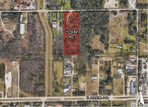
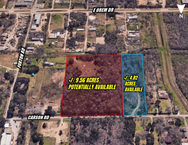
0 Carson Rd, Houston, TX 77048


Property Detail
0 Carson Rd
Houston-Pasadena-The Woodlands, TX
TR 3C E 1/2 OF LT 3 MINNETEX PLACE
0261110000045
HARRIS
Vacantlandnec
Texas
B and X Area of moderate flood hazard, usually the area between the limits of the 100-year and 500-year floods.
3
2024
4.82 AC
2025
South
331602
Houston
NEARBY LISTINGS FOR SALE OR LEASE
DEMOGRAPHICS near 0 Carson Rd
1 mile
3 mile
5 mile
2025 Total Population
3,611
67,022
260,180
2030 Population
4,017
72,246
279,892
Pop Growth 2025-2030
+ 11.24%
+ 7.79%
+ 7.58%
Average Age
31
37
37
2025 Total Households
1,082
22,495
88,487
HH Growth 2025-2030
+ 11.37%
+ 7.95%
+ 7.86%
Median Household Inc
$70,169
$57,551
$56,979
Avg Household Size
3.20
2.90
2.90
2025 Avg HH Vehicles
2.00
2.00
2.00
Median Home Value
$256,377
$201,981
$224,254
Median Year Built
2010
1974
1978
Nearby Places
Map Layers
Map Styles
 Street
 Aerial
Transit
 Traffic
 Biking
Places
Listings with unknown addresses are not visible on the map
- Restaurants
- Banks
- Shops
- Fitness
- Groceries
PUBLIC TRANSPORTATION
AIRPORT
William P Hobby
Drive
Walk
Distance
William P Hobby
12 min
4.1 mi
George Bush Intcntl/Houston
Drive
Walk
Distance
George Bush Intcntl/Houston
45 min
29.4 mi
Freight Ports
Port of Houston
Drive
Walk
Distance
Port of Houston
22 min
11.0 mi
SALE & LEASE HISTORY
LISTING DATE
SALE/LEASE

May 01, 2024
For Sale
Jun 10, 2025
For Sale
Nearby Properties
Address
Land Use
TOTAL SIZE
Lot Size
Zoning
Address
Land Use
TOTAL SIZE
Lot Size
Zoning
1,226,700 SF
92.85 AC
Address
Land Use
TOTAL SIZE
Lot Size
Zoning
603,780 SF
36.94 AC
Address
Land Use
TOTAL SIZE
Lot Size
Zoning
375,863 SF
16.35 AC
Address
Land Use
TOTAL SIZE
Lot Size
Zoning
589,830 SF
47.20 AC
Address
Land Use
TOTAL SIZE
Lot Size
Zoning
421,680 SF
23.44 AC
Address
Land Use
TOTAL SIZE
Lot Size
Zoning
273,854 SF
9.57 AC
Address
Land Use
TOTAL SIZE
Lot Size
Zoning
217,822 SF
8.12 AC
Address
Land Use
TOTAL SIZE
Lot Size
Zoning
389,108 SF
37.39 AC
Address
Land Use
TOTAL SIZE
Lot Size
Zoning
316,800 SF
16.03 AC
Address
Land Use
TOTAL SIZE
Lot Size
Zoning
556,568 SF
20 AC
Address
Land Use
TOTAL SIZE
Lot Size
Zoning
196,000 SF
29.42 AC
Address
Land Use
TOTAL SIZE
Lot Size
Zoning
239,458 SF
15.57 AC
Address
Land Use
TOTAL SIZE
Lot Size
Zoning
291,181 SF
11.07 AC
Address
Land Use
TOTAL SIZE
Lot Size
Zoning
285,328 SF
40.75 AC
Address
Land Use
TOTAL SIZE
Lot Size
Zoning
367,096 SF
15.76 AC
Address
Land Use
TOTAL SIZE
Lot Size
Zoning
353,676 SF
19.86 AC
Address
Land Use
TOTAL SIZE
Lot Size
Zoning
199,360 SF
11.13 AC
Address
Land Use
TOTAL SIZE
Lot Size
Zoning
284,290 SF
20 AC
Address
Land Use
TOTAL SIZE
Lot Size
Zoning
161,000 SF
9.82 AC
Address
Land Use
TOTAL SIZE
Lot Size
Zoning
433,760 SF
52.70 AC
Address
Land Use
TOTAL SIZE
Lot Size
Zoning
195,856 SF
20.81 AC
Address
Land Use
TOTAL SIZE
Lot Size
Zoning
164,515 SF
Address
Land Use
TOTAL SIZE
Lot Size
Zoning
165,880 SF
19.20 AC
Address
Land Use
TOTAL SIZE
Lot Size
Zoning
67,755 SF
19.53 AC
Address
Land Use
TOTAL SIZE
Lot Size
Zoning
85,323 SF
37.81 AC
Address
Land Use
TOTAL SIZE
Lot Size
Zoning
71,340 SF
47.16 AC
Address
Land Use
TOTAL SIZE
Lot Size
Zoning
108,990 SF
7.67 AC
Address
Land Use
TOTAL SIZE
Lot Size
Zoning
45,038 SF
79.61 AC
Address
Land Use
TOTAL SIZE
Lot Size
Zoning
90,250 SF
9.99 AC
Address
Land Use
TOTAL SIZE
Lot Size
Zoning
132,610 SF
12.17 AC
The World's #1 Commercial Real Estate Marketplace
Connect with us
© 2026 CoStar Group
The information above has been obtained from sources believed reliable. While we do not doubt its accuracy we have not verified it and make no guarantee, warranty or representation about it. It is your responsibility to independently confirm its accuracy and completeness. Any projections, opinions, assumptions, or estimates used are for example only and do not represent the current or future performance of the property. The value of this transaction to you depends on tax and other factors which should be evaluated by your tax, financial, and legal advisors. You and your advisors should conduct a careful, independent investigation of the property to determine to your satisfaction the suitability of the property for your needs.