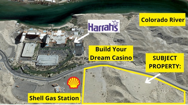
Property Record
3011 Casino Dr, Laughlin, NV 89029


Property Detail
3011 Casino Dr
Las Vegas-Henderson-North Las Vegas, NV
PARCEL MAP FILE 54 PAGE 79 LOT 1
264-24-401-001
CLARK
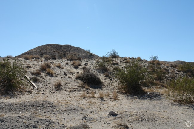
Vacantlandnec
Nevada
R-4
1
B and X Area of moderate flood hazard, usually the area between the limits of the 100-year and 500-year floods.
16.94 AC
2026
Outlying S Clark County
2026
Las Vegas
005704
NEARBY LISTINGS FOR SALE OR LEASE
DEMOGRAPHICS near 3011 Casino Dr
1 mile
3 mile
5 mile
2024 Total Population
1,062
25,670
52,011
2029 Population
1,092
26,919
55,016
Pop Growth 2024-2029
+ 2.82%
+ 4.87%
+ 5.78%
Average Age
52
51
50
2024 Total Households
563
12,348
23,905
HH Growth 2024-2029
+ 3.20%
+ 4.89%
+ 5.72%
Median Household Inc
$18,837
$46,514
$46,960
Avg Household Size
1.80
2.00
2.10
2024 Avg HH Vehicles
1.00
2.00
2.00
Median Home Value
$276,470
$231,447
$228,790
Median Year Built
1989
1990
1991
Nearby Places
Map Layers
Map Styles
 Street
 Aerial
Transit
 Traffic
 Biking
Places
Listings with unknown addresses are not visible on the map
- Restaurants
- Banks
- Shops
- Fitness
- Groceries
PUBLIC TRANSPORTATION
AIRPORT
Laughlin/Bullhead International
Drive
Walk
Distance
Laughlin/Bullhead International
13 min
4.8 mi
Freight Ports
Port of San Diego
Drive
Walk
Distance
Port of San Diego
387 min
341.8 mi
SALE & LEASE HISTORY
LISTING DATE
SALE/LEASE

Oct 11, 2016
For Sale
Nov 23, 2021
For Sale
Nearby Properties
Address
Land Use
TOTAL SIZE
Lot Size
Zoning
Address
Land Use
TOTAL SIZE
Lot Size
Zoning
69,478 SF
17.20 AC
H1
Address
Land Use
TOTAL SIZE
Lot Size
Zoning
196,664 SF
18.43 AC
H1
Address
Land Use
TOTAL SIZE
Lot Size
Zoning
188,121 SF
44.47 AC
Address
Land Use
TOTAL SIZE
Lot Size
Zoning
235,806 SF
34.57 AC
H1
Address
Land Use
TOTAL SIZE
Lot Size
Zoning
256,872 SF
47.81 AC
Address
Land Use
TOTAL SIZE
Lot Size
Zoning
386,635 SF
8 AC
Address
Land Use
TOTAL SIZE
Lot Size
Zoning
15,750 SF
27.78 AC
H1
Address
Land Use
TOTAL SIZE
Lot Size
Zoning
8,976 SF
5.40 AC
H1
Address
Land Use
TOTAL SIZE
Lot Size
Zoning
152,143 SF
39.95 AC
Address
Land Use
TOTAL SIZE
Lot Size
Zoning
53,240 SF
9.78 AC
Address
Land Use
TOTAL SIZE
Lot Size
Zoning
68.87 AC
Address
Land Use
TOTAL SIZE
Lot Size
Zoning
850,418 SF
20.44 AC
H1
Address
Land Use
TOTAL SIZE
Lot Size
Zoning
21,950 SF
7.57 AC
H1
Address
Land Use
TOTAL SIZE
Lot Size
Zoning
55,402 SF
3.24 AC
Address
Land Use
TOTAL SIZE
Lot Size
Zoning
274,070 SF
10 AC
H1
Address
Land Use
TOTAL SIZE
Lot Size
Zoning
181,040 SF
16.02 AC
Address
Land Use
TOTAL SIZE
Lot Size
Zoning
80 AC
RU
Address
Land Use
TOTAL SIZE
Lot Size
Zoning
1,606 SF
51.05 AC
Address
Land Use
TOTAL SIZE
Lot Size
Zoning
109,753 SF
15.58 AC
Address
Land Use
TOTAL SIZE
Lot Size
Zoning
120,315 SF
4.86 AC
Address
Land Use
TOTAL SIZE
Lot Size
Zoning
150,175 SF
8.88 AC
Address
Land Use
TOTAL SIZE
Lot Size
Zoning
525,752 SF
7.87 AC
Address
Land Use
TOTAL SIZE
Lot Size
Zoning
2,906 SF
14.24 AC
RU
Address
Land Use
TOTAL SIZE
Lot Size
Zoning
1,011,986 SF
17.67 AC
H1
Address
Land Use
TOTAL SIZE
Lot Size
Zoning
106,877 SF
5 AC
Address
Land Use
TOTAL SIZE
Lot Size
Zoning
8,747 SF
320 AC
PF
Address
Land Use
TOTAL SIZE
Lot Size
Zoning
30,040 SF
69.29 AC
RVP
Address
Land Use
TOTAL SIZE
Lot Size
Zoning
20,792 SF
4.96 AC
Address
Land Use
TOTAL SIZE
Lot Size
Zoning
896 SF
27.33 AC
Address
Land Use
TOTAL SIZE
Lot Size
Zoning
68.10 AC
The World's #1 Commercial Real Estate Marketplace
Connect with us
© 2026 CoStar Group
The information above has been obtained from sources believed reliable. While we do not doubt its accuracy we have not verified it and make no guarantee, warranty or representation about it. It is your responsibility to independently confirm its accuracy and completeness. Any projections, opinions, assumptions, or estimates used are for example only and do not represent the current or future performance of the property. The value of this transaction to you depends on tax and other factors which should be evaluated by your tax, financial, and legal advisors. You and your advisors should conduct a careful, independent investigation of the property to determine to your satisfaction the suitability of the property for your needs.