Property Record
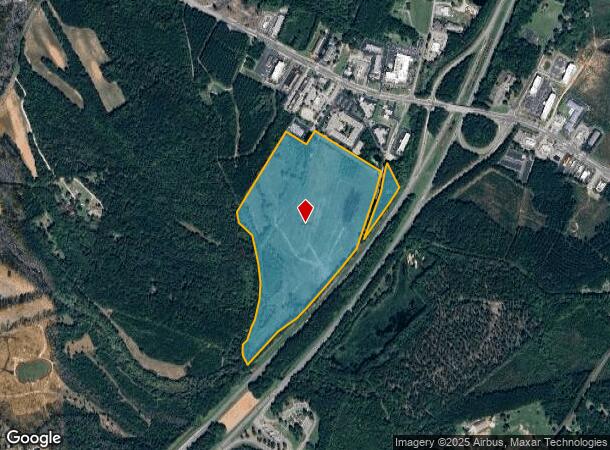
Cedar Creek Rd, Fayetteville, NC 28312
This Property Is For Sale
NEARBY LISTINGS FOR SALE OR LEASE
Property Detail
Cedar Creek Rd
Fayetteville, NC
I-95 Area
0455-16-6197
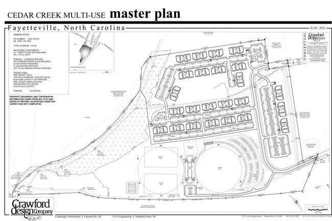
69.94 ACS MARTIN & FORT LD OFF 2007
Commercialacreage
Cumberland
X
North Carolina
3720044400J
6197
2025
69.94 AC
2025
East Fayetteville
002801
Fayetteville
DEMOGRAPHICS near Cedar Creek Rd
1 Mile
3 Mile
5 Mile
2024 Total Population
575
5,584
25,806
2029 Population
571
5,590
26,019
Pop Growth 2024-2029
(0.70%)
+ 0.11%
+ 0.83%
Average Age
39
39
38
2024 Total Households
234
2,211
10,075
HH Growth 2024-2029
(0.85%)
+ 0.09%
+ 0.88%
Median Household Inc
$63,125
$47,826
$45,026
Avg Household Size
2.40
2.50
2.40
2024 Avg HH Vehicles
2.00
2.00
2.00
Median Home Value
$117,857
$134,422
$166,093
Median Year Built
1995
1988
1991
Nearby Places
Map Layers
Map Styles
 Street
 Aerial
- Restaurants
- Banks
- Shops
- Fitness
- Groceries
PUBLIC TRANSPORTATION
COMMUTER RAIL
Fayetteville Amtrak Station (Palmetto - Amtrak, Silver Meteor - Amtrak)
DRIVE
WALK
Distance
Fayetteville Amtrak Station (Palmetto - Amtrak, Silver Meteor - Amtrak)
11 min
6.2 mi
AIRPORT
Fayetteville Regional/Grannis Field
DRIVE
WALK
Distance
Fayetteville Regional/Grannis Field
14 min
8.5 mi
Freight Ports
Port of Wilmington
DRIVE
WALK
Distance
Port of Wilmington
121 min
84.5 mi
Nearby Properties
Address
Land Use
TOTAL SIZE
Lot Size
Zoning
Address
Land Use
TOTAL SIZE
Lot Size
Zoning
627,000 SF
81.24 AC
HI
Address
Land Use
TOTAL SIZE
Lot Size
Zoning
946 SF
3.38 AC
CC-COMMUNI
Address
Land Use
TOTAL SIZE
Lot Size
Zoning
36,758 SF
4.23 AC
CC
Address
Land Use
TOTAL SIZE
Lot Size
Zoning
33,802 SF
9.95 AC
CC
Address
Land Use
TOTAL SIZE
Lot Size
Zoning
3.59 AC
CC
Address
Land Use
TOTAL SIZE
Lot Size
Zoning
16,782 SF
2.87 AC
CC
Address
Land Use
TOTAL SIZE
Lot Size
Zoning
12,650 SF
2.05 AC
CC
Address
Land Use
TOTAL SIZE
Lot Size
Zoning
MP-PLND IN
Address
Land Use
TOTAL SIZE
Lot Size
Zoning
48,044 SF
11.63 AC
LC
Address
Land Use
TOTAL SIZE
Lot Size
Zoning
1,970 SF
8.73 AC
SF6
Address
Land Use
TOTAL SIZE
Lot Size
Zoning
5,285 SF
3.18 AC
CC
Address
Land Use
TOTAL SIZE
Lot Size
Zoning
5,544 SF
244.73 AC
MP
Address
Land Use
TOTAL SIZE
Lot Size
Zoning
1,970 SF
4.54 AC
SF6
Address
Land Use
TOTAL SIZE
Lot Size
Zoning
2,000 SF
4.88 AC
SF6
Address
Land Use
TOTAL SIZE
Lot Size
Zoning
71,781 SF
10.07 AC
CP
Address
Land Use
TOTAL SIZE
Lot Size
Zoning
3,325 SF
9.60 AC
R6A
Address
Land Use
TOTAL SIZE
Lot Size
Zoning
63,164 SF
118.80 AC
MP
Address
Land Use
TOTAL SIZE
Lot Size
Zoning
13,030 SF
4.35 AC
CC
Address
Land Use
TOTAL SIZE
Lot Size
Zoning
11,137 SF
2.39 AC
CC
Address
Land Use
TOTAL SIZE
Lot Size
Zoning
5,604 SF
3 AC
CC
Address
Land Use
TOTAL SIZE
Lot Size
Zoning
4,744 SF
4.08 AC
CC
Address
Land Use
TOTAL SIZE
Lot Size
Zoning
9,512 SF
3 AC
CC
Address
Land Use
TOTAL SIZE
Lot Size
Zoning
504 SF
45.69 AC
R6A
Address
Land Use
TOTAL SIZE
Lot Size
Zoning
4,405 SF
4.27 AC
R6A
Address
Land Use
TOTAL SIZE
Lot Size
Zoning
10,004 SF
1.60 AC
CC
Address
Land Use
TOTAL SIZE
Lot Size
Zoning
924 SF
2.97 AC
SF15
Address
Land Use
TOTAL SIZE
Lot Size
Zoning
57,543 SF
7.69 AC
CP
Address
Land Use
TOTAL SIZE
Lot Size
Zoning
8,000 SF
23.41 AC
MP
Address
Land Use
TOTAL SIZE
Lot Size
Zoning
2,926 SF
26.88 AC
MP
Address
Land Use
TOTAL SIZE
Lot Size
Zoning
13,622 SF
4.35 AC
CC
The World's #1 Commercial Real Estate Marketplace
Connect with us
© 2026 CoStar Group
The information above has been obtained from sources believed reliable. While we do not doubt its accuracy we have not verified it and make no guarantee, warranty or representation about it. It is your responsibility to independently confirm its accuracy and completeness. Any projections, opinions, assumptions, or estimates used are for example only and do not represent the current or future performance of the property. The value of this transaction to you depends on tax and other factors which should be evaluated by your tax, financial, and legal advisors. You and your advisors should conduct a careful, independent investigation of the property to determine to your satisfaction the suitability of the property for your needs.