Property Record
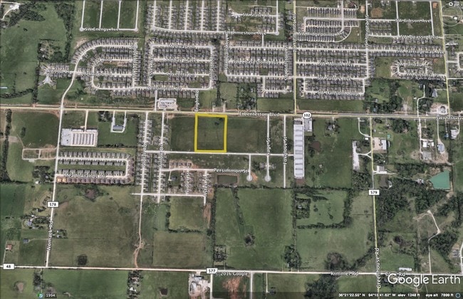
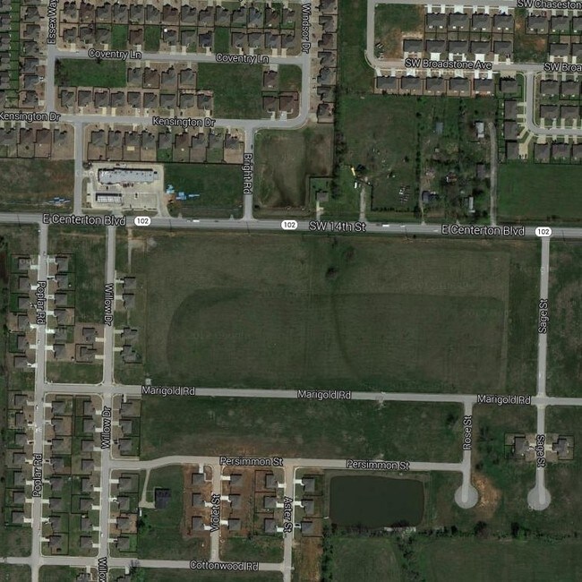
Cedar St, Centerton, AR 72719

Property Detail
Cedar St
Fayetteville-Springdale-Rogers, AR
REPLAT 6/19/2018 L201831497, REPLAT 8/17/2022 L202254196, EASEMENT VACA PLAT 10/12/2022 L202265371 & REPLAT 2/05/2025 L202506217
06-03788-003
BENTON
Commercialacreage
Arkansas
B and X Area of moderate flood hazard, usually the area between the limits of the 100-year and 500-year floods.
2d-1
2025
7.38 AC
2025
Outlying Benton County
020904
Fayetteville/Springdale/Rogers
NEARBY LISTINGS FOR SALE OR LEASE
DEMOGRAPHICS near Cedar St
1 mile
3 mile
5 mile
2025 Total Population
10,449
55,788
89,472
2030 Population
11,500
62,101
99,737
Pop Growth 2025-2030
+ 10.06%
+ 11.32%
+ 11.47%
Average Age
32
34
35
2025 Total Households
3,740
19,777
33,303
HH Growth 2025-2030
+ 10.51%
+ 11.65%
+ 11.78%
Median Household Inc
$111,605
$119,145
$112,400
Avg Household Size
2.80
2.80
2.60
2025 Avg HH Vehicles
2.00
2.00
2.00
Median Home Value
$371,379
$407,648
$426,891
Median Year Built
2007
2009
2007
Nearby Places
Map Layers
Map Styles
 Street
 Aerial
Transit
 Traffic
 Biking
Places
Listings with unknown addresses are not visible on the map
- Restaurants
- Banks
- Shops
- Fitness
- Groceries
PUBLIC TRANSPORTATION
AIRPORT
Northwest Arkansas Ntl
Drive
Walk
Distance
Northwest Arkansas Ntl
20 min
8.6 mi
Freight Ports
Tulsa Port of Inola
Drive
Walk
Distance
Tulsa Port of Inola
114 min
90.1 mi
SALE & LEASE HISTORY
LISTING DATE
SALE/LEASE

Sep 27, 2017
For Sale
Jan 10, 2017
For Sale
Nearby Properties
Address
Land Use
TOTAL SIZE
Lot Size
Zoning
Address
Land Use
TOTAL SIZE
Lot Size
Zoning
18,622 SF
104.67 AC
Address
Land Use
TOTAL SIZE
Lot Size
Zoning
516,588 SF
24.53 AC
Address
Land Use
TOTAL SIZE
Lot Size
Zoning
1,159,141 SF
176.54 AC
Address
Land Use
TOTAL SIZE
Lot Size
Zoning
187,529 SF
37.78 AC
Address
Land Use
TOTAL SIZE
Lot Size
Zoning
254,163 SF
10.98 AC
Address
Land Use
TOTAL SIZE
Lot Size
Zoning
458,697 SF
35.35 AC
Address
Land Use
TOTAL SIZE
Lot Size
Zoning
283,760 SF
11.61 AC
Address
Land Use
TOTAL SIZE
Lot Size
Zoning
256,469 SF
3.18 AC
Address
Land Use
TOTAL SIZE
Lot Size
Zoning
218,437 SF
17.90 AC
Address
Land Use
TOTAL SIZE
Lot Size
Zoning
199,773 SF
14.09 AC
Address
Land Use
TOTAL SIZE
Lot Size
Zoning
207,431 SF
14.19 AC
Address
Land Use
TOTAL SIZE
Lot Size
Zoning
290,030 SF
Address
Land Use
TOTAL SIZE
Lot Size
Zoning
191,510 SF
16.04 AC
Address
Land Use
TOTAL SIZE
Lot Size
Zoning
239,145 SF
32.91 AC
Address
Land Use
TOTAL SIZE
Lot Size
Zoning
117,513 SF
18.71 AC
Address
Land Use
TOTAL SIZE
Lot Size
Zoning
284,896 SF
13.43 AC
Address
Land Use
TOTAL SIZE
Lot Size
Zoning
271,880 SF
14.63 AC
Address
Land Use
TOTAL SIZE
Lot Size
Zoning
175,184 SF
1.12 AC
Address
Land Use
TOTAL SIZE
Lot Size
Zoning
179,182 SF
19.21 AC
Address
Land Use
TOTAL SIZE
Lot Size
Zoning
27,874 SF
0.48 AC
Address
Land Use
TOTAL SIZE
Lot Size
Zoning
21,846 SF
10.20 AC
Address
Land Use
TOTAL SIZE
Lot Size
Zoning
147,832 SF
21.01 AC
Address
Land Use
TOTAL SIZE
Lot Size
Zoning
134,695 SF
10.03 AC
Address
Land Use
TOTAL SIZE
Lot Size
Zoning
161,340 SF
4.67 AC
Address
Land Use
TOTAL SIZE
Lot Size
Zoning
214,354 SF
13.32 AC
Address
Land Use
TOTAL SIZE
Lot Size
Zoning
23,882 SF
1.57 AC
Address
Land Use
TOTAL SIZE
Lot Size
Zoning
94,184 SF
8.47 AC
Address
Land Use
TOTAL SIZE
Lot Size
Zoning
201,820 SF
8.95 AC
Address
Land Use
TOTAL SIZE
Lot Size
Zoning
177,614 SF
15.95 AC
The World's #1 Commercial Real Estate Marketplace
Connect with us
© 2026 CoStar Group
The information above has been obtained from sources believed reliable. While we do not doubt its accuracy we have not verified it and make no guarantee, warranty or representation about it. It is your responsibility to independently confirm its accuracy and completeness. Any projections, opinions, assumptions, or estimates used are for example only and do not represent the current or future performance of the property. The value of this transaction to you depends on tax and other factors which should be evaluated by your tax, financial, and legal advisors. You and your advisors should conduct a careful, independent investigation of the property to determine to your satisfaction the suitability of the property for your needs.