Property Record
Cedarhurst Dr, San Antonio, TX 78227

NEARBY LISTINGS FOR SALE OR LEASE
Property Detail
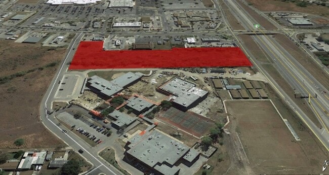
Cedarhurst Dr
San Antonio-New Braunfels, TX
Conv A/S Code
15180-000-0195
NCB 15180 BLK LOT P-19D
Vacantlandnec
Bexar
X
Texas
48029C0370G
195
2024
3.50 AC
2025
South
171802
San Antonio
DEMOGRAPHICS near Cedarhurst Dr
1 Mile
3 Mile
5 Mile
2024 Total Population
9,437
86,546
205,422
2029 Population
10,137
92,125
218,762
Pop Growth 2024-2029
+ 7.42%
+ 6.45%
+ 6.49%
Average Age
34
33
33
2024 Total Households
2,979
25,100
62,918
HH Growth 2024-2029
+ 7.75%
+ 7.01%
+ 6.84%
Median Household Inc
$51,012
$46,435
$52,866
Avg Household Size
3.10
3.10
3.10
2024 Avg HH Vehicles
2.00
2.00
2.00
Median Home Value
$151,850
$144,954
$158,499
Median Year Built
1976
1980
1990
Nearby Places
Map Layers
Map Styles
 Street
 Aerial
- Restaurants
- Banks
- Shops
- Fitness
- Groceries
PUBLIC TRANSPORTATION
AIRPORT
San Antonio International
DRIVE
WALK
Distance
San Antonio International
22 min
17.1 mi
Freight Ports
Port of Corpus Christi
DRIVE
WALK
Distance
Port of Corpus Christi
156 min
151.6 mi
SALE & LEASE HISTORY
LISTING DATE
SALE/LEASE

Nov 20, 2018
For Sale
Jan 14, 2021
For Sale
Nearby Properties
Address
Land Use
TOTAL SIZE
Lot Size
Zoning
Address
Land Use
TOTAL SIZE
Lot Size
Zoning
369,951 SF
21.42 AC
Address
Land Use
TOTAL SIZE
Lot Size
Zoning
505,914 SF
41.01 AC
Address
Land Use
TOTAL SIZE
Lot Size
Zoning
256,992 SF
10.87 AC
Address
Land Use
TOTAL SIZE
Lot Size
Zoning
286,881 SF
37.13 AC
Address
Land Use
TOTAL SIZE
Lot Size
Zoning
288,476 SF
9.87 AC
Address
Land Use
TOTAL SIZE
Lot Size
Zoning
248,405 SF
14.04 AC
Address
Land Use
TOTAL SIZE
Lot Size
Zoning
240,775 SF
13.63 AC
Address
Land Use
TOTAL SIZE
Lot Size
Zoning
247.88 AC
Address
Land Use
TOTAL SIZE
Lot Size
Zoning
2,457 SF
60.19 AC
Address
Land Use
TOTAL SIZE
Lot Size
Zoning
168,273 SF
23.13 AC
Address
Land Use
TOTAL SIZE
Lot Size
Zoning
149,184 SF
7.42 AC
Address
Land Use
TOTAL SIZE
Lot Size
Zoning
229,416 SF
12 AC
Address
Land Use
TOTAL SIZE
Lot Size
Zoning
186,797 SF
23.22 AC
Address
Land Use
TOTAL SIZE
Lot Size
Zoning
73,567 SF
18 AC
Address
Land Use
TOTAL SIZE
Lot Size
Zoning
223,403 SF
15.98 AC
Address
Land Use
TOTAL SIZE
Lot Size
Zoning
235,873 SF
12.50 AC
Address
Land Use
TOTAL SIZE
Lot Size
Zoning
127,500 SF
37.50 AC
Address
Land Use
TOTAL SIZE
Lot Size
Zoning
128,200 SF
10.66 AC
Address
Land Use
TOTAL SIZE
Lot Size
Zoning
247,258 SF
12.54 AC
Address
Land Use
TOTAL SIZE
Lot Size
Zoning
107,135 SF
6.62 AC
Address
Land Use
TOTAL SIZE
Lot Size
Zoning
109,420 SF
215.95 AC
Address
Land Use
TOTAL SIZE
Lot Size
Zoning
1,394 SF
72.83 AC
Address
Land Use
TOTAL SIZE
Lot Size
Zoning
131,991 SF
7.86 AC
Address
Land Use
TOTAL SIZE
Lot Size
Zoning
216,680 SF
21.92 AC
Address
Land Use
TOTAL SIZE
Lot Size
Zoning
87,790 SF
7.48 AC
Address
Land Use
TOTAL SIZE
Lot Size
Zoning
36.29 AC
Address
Land Use
TOTAL SIZE
Lot Size
Zoning
76,299 SF
7.29 AC
Address
Land Use
TOTAL SIZE
Lot Size
Zoning
38,002 SF
565.81 AC
Address
Land Use
TOTAL SIZE
Lot Size
Zoning
40,441 SF
17.01 AC
Address
Land Use
TOTAL SIZE
Lot Size
Zoning
99,248 SF
4 AC
The World's #1 Commercial Real Estate Marketplace
Connect with us
© 2025 CoStar Group
The information above has been obtained from sources believed reliable. While we do not doubt its accuracy we have not verified it and make no guarantee, warranty or representation about it. It is your responsibility to independently confirm its accuracy and completeness. Any projections, opinions, assumptions, or estimates used are for example only and do not represent the current or future performance of the property. The value of this transaction to you depends on tax and other factors which should be evaluated by your tax, financial, and legal advisors. You and your advisors should conduct a careful, independent investigation of the property to determine to your satisfaction the suitability of the property for your needs.