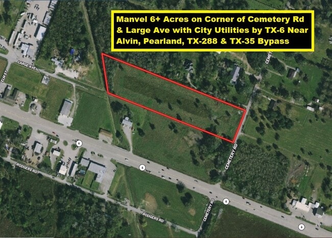
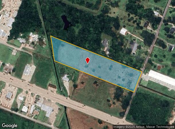
Property Record
Cemetery Rd, Manvel, TX 77578


NEARBY LISTINGS FOR SALE OR LEASE
Property Detail
Cemetery Rd
Houston-The Woodlands-Sugar Land, TX
Manvel
6398-0185-000
MANVEL LOT 2-3 (CALLIHAN SD NO 2)(OL 95-96) ACRES 6.3
Agriculturalland
Brazoria
AO
Texas
48039C0130K
2-3
2024
6.30 AC
2025
South
660708
Houston
DEMOGRAPHICS near Cemetery Rd
1 Mile
3 Mile
5 Mile
2024 Total Population
1,440
9,100
42,336
2029 Population
1,610
10,371
48,037
Pop Growth 2024-2029
+ 11.81%
+ 13.97%
+ 13.47%
Average Age
40
39
37
2024 Total Households
505
3,134
13,762
HH Growth 2024-2029
+ 11.88%
+ 14.14%
+ 13.62%
Median Household Inc
$89,423
$94,374
$93,142
Avg Household Size
2.80
2.80
3.00
2024 Avg HH Vehicles
2.00
2.00
2.00
Median Home Value
$317,172
$305,266
$312,620
Median Year Built
1989
2004
2006
Nearby Places
Map Layers
Map Styles
 Street
 Aerial
- Restaurants
- Banks
- Shops
- Fitness
- Groceries
PUBLIC TRANSPORTATION
AIRPORT
William P Hobby
DRIVE
WALK
Distance
William P Hobby
31 min
16.1 mi
Freight Ports
Port of Houston
DRIVE
WALK
Distance
Port of Houston
39 min
27.6 mi
SALE & LEASE HISTORY
LISTING DATE
SALE/LEASE

May 16, 2021
For Sale
Aug 05, 2022
For Sale
Nearby Properties
Address
Land Use
TOTAL SIZE
Lot Size
Zoning
Address
Land Use
TOTAL SIZE
Lot Size
Zoning
114.04 AC
Address
Land Use
TOTAL SIZE
Lot Size
Zoning
120,380 SF
15.56 AC
Address
Land Use
TOTAL SIZE
Lot Size
Zoning
93,990 SF
15.73 AC
Address
Land Use
TOTAL SIZE
Lot Size
Zoning
21.99 AC
0258
Address
Land Use
TOTAL SIZE
Lot Size
Zoning
65,012 SF
13 AC
Address
Land Use
TOTAL SIZE
Lot Size
Zoning
172,015 SF
18.36 AC
Address
Land Use
TOTAL SIZE
Lot Size
Zoning
17.17 AC
Address
Land Use
TOTAL SIZE
Lot Size
Zoning
28,708 SF
9.57 AC
Address
Land Use
TOTAL SIZE
Lot Size
Zoning
46,732 SF
8.64 AC
0752
Address
Land Use
TOTAL SIZE
Lot Size
Zoning
28,143 SF
13.08 AC
Address
Land Use
TOTAL SIZE
Lot Size
Zoning
3,159 SF
64.95 AC
0227
Address
Land Use
TOTAL SIZE
Lot Size
Zoning
21,300 SF
12.92 AC
Address
Land Use
TOTAL SIZE
Lot Size
Zoning
48,750 SF
2.82 AC
Address
Land Use
TOTAL SIZE
Lot Size
Zoning
11,628 SF
1.86 AC
0009
Address
Land Use
TOTAL SIZE
Lot Size
Zoning
50,400 SF
8.40 AC
0013
Address
Land Use
TOTAL SIZE
Lot Size
Zoning
14,768 SF
1.30 AC
Address
Land Use
TOTAL SIZE
Lot Size
Zoning
12,240 SF
1.46 AC
0240
Address
Land Use
TOTAL SIZE
Lot Size
Zoning
136.01 AC
0003
Address
Land Use
TOTAL SIZE
Lot Size
Zoning
34,368 SF
4.32 AC
Address
Land Use
TOTAL SIZE
Lot Size
Zoning
3,504 SF
187.33 AC
0027
Address
Land Use
TOTAL SIZE
Lot Size
Zoning
9,020 SF
3.12 AC
Address
Land Use
TOTAL SIZE
Lot Size
Zoning
3,257 SF
105.55 AC
0428
Address
Land Use
TOTAL SIZE
Lot Size
Zoning
25,200 SF
5.08 AC
Address
Land Use
TOTAL SIZE
Lot Size
Zoning
36,684 SF
1.47 AC
Address
Land Use
TOTAL SIZE
Lot Size
Zoning
50,958 SF
10.33 AC
Address
Land Use
TOTAL SIZE
Lot Size
Zoning
14,360 SF
1.99 AC
Address
Land Use
TOTAL SIZE
Lot Size
Zoning
14,771 SF
4.18 AC
Address
Land Use
TOTAL SIZE
Lot Size
Zoning
7,662 SF
1.11 AC
Address
Land Use
TOTAL SIZE
Lot Size
Zoning
74,352 SF
4.31 AC
Address
Land Use
TOTAL SIZE
Lot Size
Zoning
13,750 SF
12.42 AC
0222
The World's #1 Commercial Real Estate Marketplace
Connect with us
© 2025 CoStar Group
The information above has been obtained from sources believed reliable. While we do not doubt its accuracy we have not verified it and make no guarantee, warranty or representation about it. It is your responsibility to independently confirm its accuracy and completeness. Any projections, opinions, assumptions, or estimates used are for example only and do not represent the current or future performance of the property. The value of this transaction to you depends on tax and other factors which should be evaluated by your tax, financial, and legal advisors. You and your advisors should conduct a careful, independent investigation of the property to determine to your satisfaction the suitability of the property for your needs.