Property Record
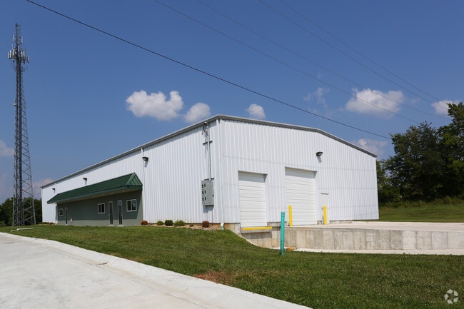
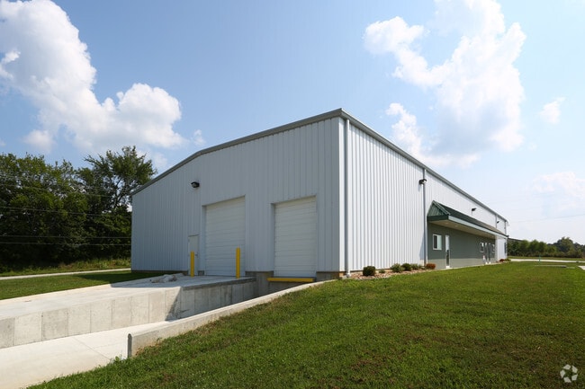
Century Commerce Loop, Labadie, MO 63055

Property Detail
Century Commerce Loop
09-8-33.0-0-000-023.000
LEASED WAREHOUSE SPACEPT SE SW, E OF NEW HWY 100W OF OLD HWY 100
Realpropertynec
FRANKLIN
B and X Area of moderate flood hazard, usually the area between the limits of the 100-year and 500-year floods.
Missouri
2025
7.90 AC
2025
Franklin County
800101
St. Louis
11,088 SF
St. Louis, MO-IL
NEARBY LISTINGS FOR SALE OR LEASE
-
-
View all Labadie listings for lease on LoopNet.com
DEMOGRAPHICS near Century Commerce Loop
1 mile
3 mile
5 mile
2025 Total Population
597
2,955
13,498
2030 Population
609
3,020
13,758
Pop Growth 2025-2030
+ 2.01%
+ 2.20%
+ 1.93%
Average Age
44
44
44
2025 Total Households
218
1,100
5,282
HH Growth 2025-2030
+ 2.29%
+ 2.27%
+ 2.01%
Median Household Inc
$90,624
$83,967
$82,211
Avg Household Size
2.70
2.70
2.50
2025 Avg HH Vehicles
3.00
3.00
2.00
Median Home Value
$548,913
$430,088
$296,119
Median Year Built
1996
1993
1989
Nearby Places
Map Layers
Map Styles
 Street
 Aerial
Layers
 Traffic
 Biking
Places
Listings with unknown addresses are not visible on the map
- Restaurants
- Banks
- Shops
- Fitness
- Groceries
SALE & LEASE HISTORY
LISTING DATE
SALE/LEASE

Sep 25, 2016
For Lease
Jun 18, 2019
For Lease
Dec 07, 2018
For Lease
Nearby Properties
Address
Land Use
TOTAL SIZE
Lot Size
Zoning
Address
Land Use
TOTAL SIZE
Lot Size
Zoning
Address
Land Use
TOTAL SIZE
Lot Size
Zoning
3,412 SF
32 AC
ANU
Address
Land Use
TOTAL SIZE
Lot Size
Zoning
4,080 SF
6.10 AC
ANU
Address
Land Use
TOTAL SIZE
Lot Size
Zoning
10,650 SF
9.50 AC
SD
Address
Land Use
TOTAL SIZE
Lot Size
Zoning
Address
Land Use
TOTAL SIZE
Lot Size
Zoning
23,702 SF
15 AC
Address
Land Use
TOTAL SIZE
Lot Size
Zoning
Address
Land Use
TOTAL SIZE
Lot Size
Zoning
19,200 SF
7.20 AC
CA
Address
Land Use
TOTAL SIZE
Lot Size
Zoning
4,405 SF
4 AC
ANU
Address
Land Use
TOTAL SIZE
Lot Size
Zoning
6,386 SF
50.50 AC
ANU
Address
Land Use
TOTAL SIZE
Lot Size
Zoning
12,194 SF
6.60 AC
CA
Address
Land Use
TOTAL SIZE
Lot Size
Zoning
12,000 SF
2.10 AC
Address
Land Use
TOTAL SIZE
Lot Size
Zoning
21,280 SF
11.60 AC
Address
Land Use
TOTAL SIZE
Lot Size
Zoning
8,400 SF
1.10 AC
Address
Land Use
TOTAL SIZE
Lot Size
Zoning
2,242 SF
1.20 AC
ANU
Address
Land Use
TOTAL SIZE
Lot Size
Zoning
3,789 SF
0.60 AC
Address
Land Use
TOTAL SIZE
Lot Size
Zoning
71 AC
ANU
Address
Land Use
TOTAL SIZE
Lot Size
Zoning
3,036 SF
52.90 AC
SD
Address
Land Use
TOTAL SIZE
Lot Size
Zoning
8.10 AC
SD
Address
Land Use
TOTAL SIZE
Lot Size
Zoning
13.40 AC
ANU
Address
Land Use
TOTAL SIZE
Lot Size
Zoning
1,703 SF
0.40 AC
Address
Land Use
TOTAL SIZE
Lot Size
Zoning
1,865 SF
0.30 AC
Address
Land Use
TOTAL SIZE
Lot Size
Zoning
3,116 SF
10.90 AC
ANU
Address
Land Use
TOTAL SIZE
Lot Size
Zoning
2.20 AC
ANU
Address
Land Use
TOTAL SIZE
Lot Size
Zoning
10,571 SF
1.30 AC
ANU
Address
Land Use
TOTAL SIZE
Lot Size
Zoning
31.10 AC
ANU
Address
Land Use
TOTAL SIZE
Lot Size
Zoning
9.40 AC
ANU
Address
Land Use
TOTAL SIZE
Lot Size
Zoning
49.80 AC
ANU
Address
Land Use
TOTAL SIZE
Lot Size
Zoning
The World's #1 Commercial Real Estate Marketplace
Connect with us
© 2026 CoStar Group
The information above has been obtained from sources believed reliable. While we do not doubt its accuracy we have not verified it and make no guarantee, warranty or representation about it. It is your responsibility to independently confirm its accuracy and completeness. Any projections, opinions, assumptions, or estimates used are for example only and do not represent the current or future performance of the property. The value of this transaction to you depends on tax and other factors which should be evaluated by your tax, financial, and legal advisors. You and your advisors should conduct a careful, independent investigation of the property to determine to your satisfaction the suitability of the property for your needs.