Property Record
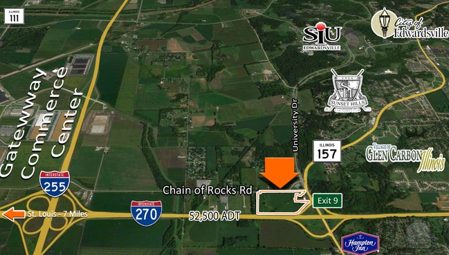
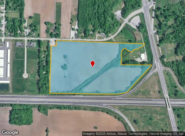
Chain Of Rocks Rd, Edwardsville, IL 62025

NEARBY LISTINGS FOR SALE OR LEASE
Property Detail
Chain Of Rocks Rd
St. Louis, MO-IL
TR E 3/4 N 1/2
14-1-15-32-00-000-003
Madison
Agriculturalland
Illinois
2024
39.29 AC
2024
Illinois
402900
St. Louis
DEMOGRAPHICS near Chain Of Rocks Rd
1 Mile
3 Mile
5 Mile
2024 Total Population
1,442
14,438
64,369
2029 Population
1,440
14,247
63,788
Pop Growth 2024-2029
(0.14%)
(1.32%)
(0.90%)
Average Age
40
41
40
2024 Total Households
496
5,607
24,768
HH Growth 2024-2029
(0.20%)
(1.44%)
(0.95%)
Median Household Inc
$92,628
$88,223
$77,955
Avg Household Size
2.50
2.40
2.40
2024 Avg HH Vehicles
2.00
2.00
2.00
Median Home Value
$269,135
$270,837
$206,266
Median Year Built
1990
1989
1987
Nearby Places
Map Layers
Map Styles
 Street
 Aerial
- Restaurants
- Banks
- Shops
- Fitness
- Groceries
PUBLIC TRANSPORTATION
AIRPORT
St Louis Lambert International
DRIVE
WALK
Distance
St Louis Lambert International
29 min
21.4 mi
Scott AFB/Midamerica St Louis
DRIVE
WALK
Distance
Scott AFB/Midamerica St Louis
44 min
27.9 mi
Freight Ports
Port Milwaukee
DRIVE
WALK
Distance
Port Milwaukee
401 min
356.2 mi
SALE & LEASE HISTORY
LISTING DATE
SALE/LEASE

Sep 24, 2016
For Sale
Nearby Properties
Address
Land Use
TOTAL SIZE
Lot Size
Zoning
Address
Land Use
TOTAL SIZE
Lot Size
Zoning
24,564 SF
90.20 AC
Address
Land Use
TOTAL SIZE
Lot Size
Zoning
582,352 SF
64.37 AC
Address
Land Use
TOTAL SIZE
Lot Size
Zoning
Address
Land Use
TOTAL SIZE
Lot Size
Zoning
7,076 SF
55.77 AC
Address
Land Use
TOTAL SIZE
Lot Size
Zoning
14,712 SF
78.60 AC
Address
Land Use
TOTAL SIZE
Lot Size
Zoning
Address
Land Use
TOTAL SIZE
Lot Size
Zoning
978,612 SF
66.18 AC
Address
Land Use
TOTAL SIZE
Lot Size
Zoning
44.84 AC
Address
Land Use
TOTAL SIZE
Lot Size
Zoning
808,149 SF
42.14 AC
Address
Land Use
TOTAL SIZE
Lot Size
Zoning
717,060 SF
53.39 AC
Address
Land Use
TOTAL SIZE
Lot Size
Zoning
624,000 SF
33.43 AC
Address
Land Use
TOTAL SIZE
Lot Size
Zoning
672,000 SF
43.93 AC
Address
Land Use
TOTAL SIZE
Lot Size
Zoning
674,750 SF
58.72 AC
Address
Land Use
TOTAL SIZE
Lot Size
Zoning
374,400 SF
83.25 AC
Address
Land Use
TOTAL SIZE
Lot Size
Zoning
520,980 SF
47.38 AC
Address
Land Use
TOTAL SIZE
Lot Size
Zoning
733,653 SF
72.88 AC
Address
Land Use
TOTAL SIZE
Lot Size
Zoning
518,406 SF
32.60 AC
Address
Land Use
TOTAL SIZE
Lot Size
Zoning
612,900 SF
41 AC
Address
Land Use
TOTAL SIZE
Lot Size
Zoning
4.40 AC
Address
Land Use
TOTAL SIZE
Lot Size
Zoning
395,910 SF
23.96 AC
Address
Land Use
TOTAL SIZE
Lot Size
Zoning
28,164 SF
9.31 AC
Address
Land Use
TOTAL SIZE
Lot Size
Zoning
240,540 SF
54.05 AC
Address
Land Use
TOTAL SIZE
Lot Size
Zoning
3,209 SF
8.62 AC
Address
Land Use
TOTAL SIZE
Lot Size
Zoning
16,274 SF
19.78 AC
Address
Land Use
TOTAL SIZE
Lot Size
Zoning
101,340 SF
15.40 AC
Address
Land Use
TOTAL SIZE
Lot Size
Zoning
209,100 SF
25.87 AC
Address
Land Use
TOTAL SIZE
Lot Size
Zoning
85,519 SF
10.09 AC
Address
Land Use
TOTAL SIZE
Lot Size
Zoning
55,275 SF
11.75 AC
Address
Land Use
TOTAL SIZE
Lot Size
Zoning
13,104 SF
5.80 AC
Address
Land Use
TOTAL SIZE
Lot Size
Zoning
58,359 SF
5 AC
The World's #1 Commercial Real Estate Marketplace
Connect with us
© 2025 CoStar Group
The information above has been obtained from sources believed reliable. While we do not doubt its accuracy we have not verified it and make no guarantee, warranty or representation about it. It is your responsibility to independently confirm its accuracy and completeness. Any projections, opinions, assumptions, or estimates used are for example only and do not represent the current or future performance of the property. The value of this transaction to you depends on tax and other factors which should be evaluated by your tax, financial, and legal advisors. You and your advisors should conduct a careful, independent investigation of the property to determine to your satisfaction the suitability of the property for your needs.