Property Record
Chamberlain Dr, , MD

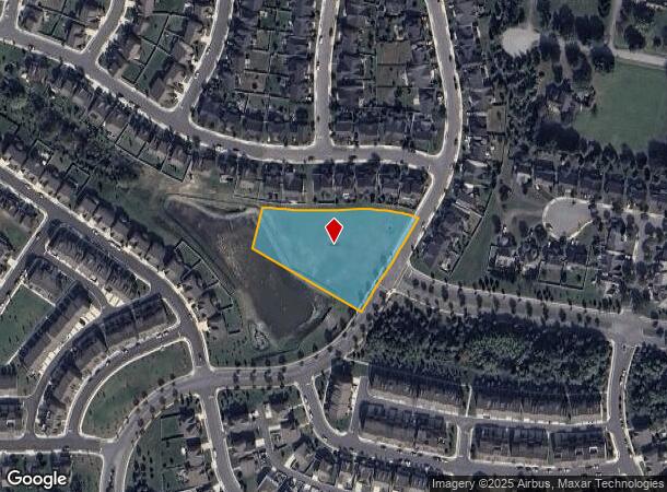
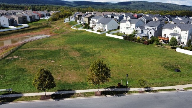

This Property Is For Sale
NEARBY LISTINGS FOR SALE OR LEASE
-
-
View all listings for sale on LoopNet.com
Property Detail
Chamberlain Dr
02-589618
1.87 ACRES CHAMBERLAIN DRIVE WALTER A AND JEAN W MART
Residentialnec
Frederick
X
Maryland
24021C0277E
1.87 AC
2024
Frederick
2025
Washington, DC
751202
Washington-Arlington-Alexandria, DC-VA-MD-WV
DEMOGRAPHICS near Chamberlain Dr
1 mile
3 mile
5 mile
2024 Total Population
5,115
36,097
107,714
2029 Population
5,952
41,360
122,403
Pop Growth 2024-2029
+ 16.36%
+ 14.58%
+ 13.64%
Average Age
42
41
40
2024 Total Households
1,751
13,459
41,104
HH Growth 2024-2029
+ 16.73%
+ 14.98%
+ 14.12%
Median Household Inc
$150,812
$108,199
$88,247
Avg Household Size
2.90
2.60
2.50
2024 Avg HH Vehicles
3.00
2.00
2.00
Median Home Value
$426,915
$370,949
$352,590
Median Year Built
2002
1995
1988
Nearby Places
Map Layers
Map Styles
 Street
 Aerial
Transit
 Traffic
 Biking
Places
Listings with unknown addresses are not visible on the map
- Restaurants
- Banks
- Shops
- Fitness
- Groceries
PUBLIC TRANSPORTATION
COMMUTER RAIL
Drive
Walk
Distance
13 min
5.9 mi
Frederick (Brunswick Line - Maryland Area Regional Commuter Trains (The MARC))
Drive
Walk
Distance
Frederick (Brunswick Line - Maryland Area Regional Commuter Trains (The MARC))
15 min
6.4 mi
AIRPORT
Hagerstown Regional/Richard A Henson Field
Drive
Walk
Distance
Hagerstown Regional/Richard A Henson Field
48 min
30.9 mi
Freight Ports
Port of Baltimore
Drive
Walk
Distance
Port of Baltimore
71 min
55.7 mi
Nearby Properties
Address
Land Use
TOTAL SIZE
Lot Size
Zoning
Address
Land Use
TOTAL SIZE
Lot Size
Zoning
530,619 SF
100.32 AC
IST
Address
Land Use
TOTAL SIZE
Lot Size
Zoning
259,468 SF
95.75 AC
IST
Address
Land Use
TOTAL SIZE
Lot Size
Zoning
150,793 SF
27.13 AC
IST
Address
Land Use
TOTAL SIZE
Lot Size
Zoning
217,295 SF
23.68 AC
GC
Address
Land Use
TOTAL SIZE
Lot Size
Zoning
221,252 SF
8.07 AC
MU1
Address
Land Use
TOTAL SIZE
Lot Size
Zoning
214,291 SF
88.13 AC
IST
Address
Land Use
TOTAL SIZE
Lot Size
Zoning
192,497 SF
7.53 AC
IST
Address
Land Use
TOTAL SIZE
Lot Size
Zoning
122,807 SF
12 AC
Address
Land Use
TOTAL SIZE
Lot Size
Zoning
243,554 SF
14.03 AC
R4
Address
Land Use
TOTAL SIZE
Lot Size
Zoning
222,736 SF
3.65 AC
MU1
Address
Land Use
TOTAL SIZE
Lot Size
Zoning
383,394 SF
83.88 AC
MU1
Address
Land Use
TOTAL SIZE
Lot Size
Zoning
90,000 SF
25.69 AC
R2
Address
Land Use
TOTAL SIZE
Lot Size
Zoning
72,744 SF
8.06 AC
R8
Address
Land Use
TOTAL SIZE
Lot Size
Zoning
51,120 SF
2.97 AC
GC
Address
Land Use
TOTAL SIZE
Lot Size
Zoning
184,800 SF
10 AC
R16
Address
Land Use
TOTAL SIZE
Lot Size
Zoning
116,240 SF
9.64 AC
PB
Address
Land Use
TOTAL SIZE
Lot Size
Zoning
57,232 SF
4.12 AC
PB
Address
Land Use
TOTAL SIZE
Lot Size
Zoning
100,868 SF
3 AC
R12
Address
Land Use
TOTAL SIZE
Lot Size
Zoning
119,192 SF
36.37 AC
IST
Address
Land Use
TOTAL SIZE
Lot Size
Zoning
58,300 SF
12.33 AC
IST
Address
Land Use
TOTAL SIZE
Lot Size
Zoning
111,993 SF
20.38 AC
R3
Address
Land Use
TOTAL SIZE
Lot Size
Zoning
219,104 SF
28.93 AC
LI
Address
Land Use
TOTAL SIZE
Lot Size
Zoning
113,182 SF
12.61 AC
Address
Land Use
TOTAL SIZE
Lot Size
Zoning
50,085 SF
1.15 AC
PB
Address
Land Use
TOTAL SIZE
Lot Size
Zoning
110,215 SF
6 AC
R20
Address
Land Use
TOTAL SIZE
Lot Size
Zoning
54,895 SF
16.12 AC
IST
Address
Land Use
TOTAL SIZE
Lot Size
Zoning
57,733 SF
6.31 AC
PND
Address
Land Use
TOTAL SIZE
Lot Size
Zoning
59,700 SF
4.86 AC
GC
Address
Land Use
TOTAL SIZE
Lot Size
Zoning
66,412 SF
3.18 AC
GC
Address
Land Use
TOTAL SIZE
Lot Size
Zoning
100,496 SF
5.32 AC
M1
The World's #1 Commercial Real Estate Marketplace
Connect with us
© 2026 CoStar Group
The information above has been obtained from sources believed reliable. While we do not doubt its accuracy we have not verified it and make no guarantee, warranty or representation about it. It is your responsibility to independently confirm its accuracy and completeness. Any projections, opinions, assumptions, or estimates used are for example only and do not represent the current or future performance of the property. The value of this transaction to you depends on tax and other factors which should be evaluated by your tax, financial, and legal advisors. You and your advisors should conduct a careful, independent investigation of the property to determine to your satisfaction the suitability of the property for your needs.