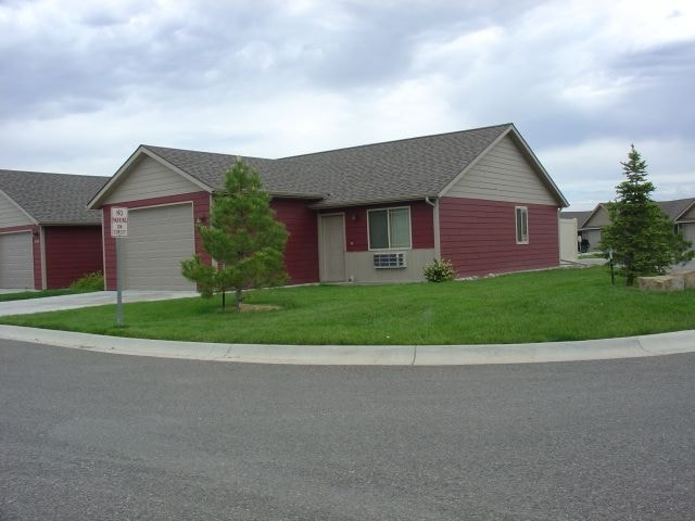
Property Record
Chanel Loop, Billings, MT 59101

Save to a Folder
{{folder.Name}}
{{folder.ListingIds.length}} Properties
{{folder.ListingIds.length}} Property
Create a New Folder
Property Detail
Chanel Loop
Billings, MT
RIVERFRONT POINTE SUB, S17, T01 S, R26 E, BLOCK 2, LOT 4A, AMD
03-0927-17-3-14-13-0000
YELLOWSTONE
Apartmenthouse5plusunits
Montana
B and X Area of moderate flood hazard, usually the area between the limits of the 100-year and 500-year floods.
4a
2025
4.93 AC
2025
Billings
000901
Other Market Areas
36,271 SF
NEARBY LISTINGS FOR SALE OR LEASE
-
-
View all Billings listings for sale on LoopNet.com
DEMOGRAPHICS near Chanel Loop
1 mile
3 mile
5 mile
2025 Total Population
3,539
42,693
92,724
2030 Population
3,698
44,027
95,681
Pop Growth 2025-2030
+ 4.49%
+ 3.12%
+ 3.19%
Average Age
38
40
41
2025 Total Households
1,551
18,463
40,327
HH Growth 2025-2030
+ 4.64%
+ 3.26%
+ 3.35%
Median Household Inc
$75,606
$57,914
$65,251
Avg Household Size
2.30
2.20
2.20
2025 Avg HH Vehicles
2.00
2.00
2.00
Median Home Value
$373,333
$288,309
$344,467
Median Year Built
2008
1972
1975
Nearby Places
Map Layers
Map Styles
 Street
 Aerial
Layers
 Traffic
 Biking
Places
Listings with unknown addresses are not visible on the map
- Restaurants
- Banks
- Shops
- Fitness
- Groceries
PUBLIC TRANSPORTATION
AIRPORT
Billings Logan International
Drive
Walk
Distance
Billings Logan International
26 min
9.6 mi
Freight Ports
Port of Everett
Drive
Walk
Distance
Port of Everett
880 min
838.6 mi
Nearby Properties
Address
Land Use
TOTAL SIZE
Lot Size
Zoning
Address
Land Use
TOTAL SIZE
Lot Size
Zoning
295,400 SF
17 AC
Address
Land Use
TOTAL SIZE
Lot Size
Zoning
136,588 SF
21.01 AC
CI
Address
Land Use
TOTAL SIZE
Lot Size
Zoning
259,684 SF
14.73 AC
Address
Land Use
TOTAL SIZE
Lot Size
Zoning
116,250 SF
9.39 AC
Address
Land Use
TOTAL SIZE
Lot Size
Zoning
537,468 SF
36.83 AC
CC
Address
Land Use
TOTAL SIZE
Lot Size
Zoning
173,807 SF
11.56 AC
CI
Address
Land Use
TOTAL SIZE
Lot Size
Zoning
218,478 SF
18.19 AC
CI
Address
Land Use
TOTAL SIZE
Lot Size
Zoning
172.22 AC
Address
Land Use
TOTAL SIZE
Lot Size
Zoning
177,290 SF
14.59 AC
HC
Address
Land Use
TOTAL SIZE
Lot Size
Zoning
188,907 SF
3.83 AC
CC
Address
Land Use
TOTAL SIZE
Lot Size
Zoning
151,056 SF
49.20 AC
A-1
Address
Land Use
TOTAL SIZE
Lot Size
Zoning
149,797 SF
12.95 AC
CC
Address
Land Use
TOTAL SIZE
Lot Size
Zoning
118,640 SF
12.55 AC
P
Address
Land Use
TOTAL SIZE
Lot Size
Zoning
1,200 SF
57.17 AC
P
Address
Land Use
TOTAL SIZE
Lot Size
Zoning
409,620 SF
27.42 AC
CI
Address
Land Use
TOTAL SIZE
Lot Size
Zoning
168,560 SF
24.67 AC
Address
Land Use
TOTAL SIZE
Lot Size
Zoning
109,485 SF
8.87 AC
R-96
Address
Land Use
TOTAL SIZE
Lot Size
Zoning
155,084 SF
13.78 AC
P
Address
Land Use
TOTAL SIZE
Lot Size
Zoning
167,744 SF
16.45 AC
CI
Address
Land Use
TOTAL SIZE
Lot Size
Zoning
20.27 AC
P
Address
Land Use
TOTAL SIZE
Lot Size
Zoning
38,313 SF
3.27 AC
Address
Land Use
TOTAL SIZE
Lot Size
Zoning
86,332 SF
11.18 AC
Address
Land Use
TOTAL SIZE
Lot Size
Zoning
178,736 SF
11.94 AC
HC
Address
Land Use
TOTAL SIZE
Lot Size
Zoning
169,281 SF
11.41 AC
Address
Land Use
TOTAL SIZE
Lot Size
Zoning
5,670 SF
53.89 AC
P
Address
Land Use
TOTAL SIZE
Lot Size
Zoning
91,354 SF
5.60 AC
Address
Land Use
TOTAL SIZE
Lot Size
Zoning
273,480 SF
9.05 AC
Address
Land Use
TOTAL SIZE
Lot Size
Zoning
136,398 SF
13.05 AC
Address
Land Use
TOTAL SIZE
Lot Size
Zoning
69,342 SF
24.57 AC
P
Address
Land Use
TOTAL SIZE
Lot Size
Zoning
10,909 SF
64.95 AC
RMH
The World's #1 Commercial Real Estate Marketplace
Connect with us
© 2026 CoStar Group
The information above has been obtained from sources believed reliable. While we do not doubt its accuracy we have not verified it and make no guarantee, warranty or representation about it. It is your responsibility to independently confirm its accuracy and completeness. Any projections, opinions, assumptions, or estimates used are for example only and do not represent the current or future performance of the property. The value of this transaction to you depends on tax and other factors which should be evaluated by your tax, financial, and legal advisors. You and your advisors should conduct a careful, independent investigation of the property to determine to your satisfaction the suitability of the property for your needs.