Property Record
Chaparral Dr, Hillsboro, TX 76645

Save to a Folder
{{folder.Name}}
{{folder.ListingIds.length}} Properties
{{folder.ListingIds.length}} Property
Create a New Folder
Property Detail
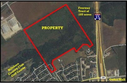
Chaparral Dr
110921
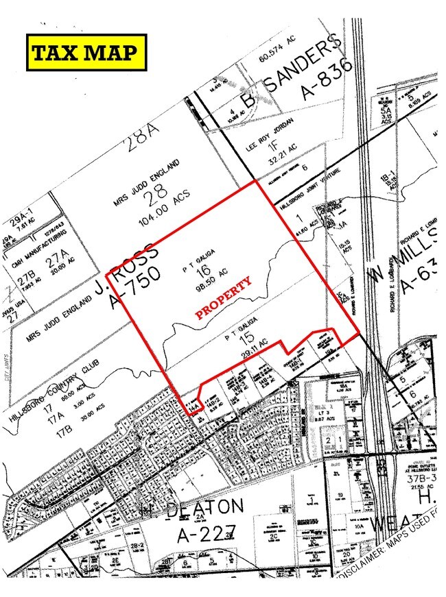
J ROSS A-750 TR 14A, 15 & 16 130.148 AC
Vacantlandnec
HILL
A Areas with a 1% annual chance of flooding and a 26% chance of flooding over the life of a 30-year mortgage.
Texas
2025
130.15 AC
2025
Central Texas Area
960800
Other Market Areas
NEARBY LISTINGS FOR SALE OR LEASE
DEMOGRAPHICS near Chaparral Dr
1 mile
3 mile
5 mile
2025 Total Population
1,822
8,919
9,613
2030 Population
1,898
9,512
10,244
Pop Growth 2025-2030
+ 4.17%
+ 6.65%
+ 6.56%
Average Age
39
37
38
2025 Total Households
726
3,169
3,430
HH Growth 2025-2030
+ 3.86%
+ 6.28%
+ 6.18%
Median Household Inc
$63,333
$61,500
$62,258
Avg Household Size
2.50
2.70
2.70
2025 Avg HH Vehicles
2.00
2.00
2.00
Median Home Value
$235,156
$159,772
$167,395
Median Year Built
1982
1975
1976
Nearby Places
Map Layers
Map Styles
 Street
 Aerial
Layers
 Traffic
 Biking
Places
Listings with unknown addresses are not visible on the map
- Restaurants
- Banks
- Shops
- Fitness
- Groceries
PUBLIC TRANSPORTATION
AIRPORT
Waco Regional
Drive
Walk
Distance
Waco Regional
52 min
39.2 mi
Freight Ports
Port of Houston
Drive
Walk
Distance
Port of Houston
247 min
216.9 mi
Nearby Properties
Address
Land Use
TOTAL SIZE
Lot Size
Zoning
Address
Land Use
TOTAL SIZE
Lot Size
Zoning
269,487 SF
70 AC
Address
Land Use
TOTAL SIZE
Lot Size
Zoning
Address
Land Use
TOTAL SIZE
Lot Size
Zoning
148,714 SF
14.92 AC
Address
Land Use
TOTAL SIZE
Lot Size
Zoning
192,060 SF
19.46 AC
Address
Land Use
TOTAL SIZE
Lot Size
Zoning
754,116 SF
77.64 AC
Address
Land Use
TOTAL SIZE
Lot Size
Zoning
273,551 SF
20.23 AC
Address
Land Use
TOTAL SIZE
Lot Size
Zoning
72,358 SF
13.99 AC
Address
Land Use
TOTAL SIZE
Lot Size
Zoning
Address
Land Use
TOTAL SIZE
Lot Size
Zoning
47,404 SF
9.94 AC
Address
Land Use
TOTAL SIZE
Lot Size
Zoning
56,252 SF
19.36 AC
Address
Land Use
TOTAL SIZE
Lot Size
Zoning
547,093 SF
16.06 AC
Address
Land Use
TOTAL SIZE
Lot Size
Zoning
29,083 SF
2.50 AC
Address
Land Use
TOTAL SIZE
Lot Size
Zoning
633,604 SF
27.95 AC
Address
Land Use
TOTAL SIZE
Lot Size
Zoning
60,680 SF
3.48 AC
Address
Land Use
TOTAL SIZE
Lot Size
Zoning
52,825 SF
5.71 AC
Address
Land Use
TOTAL SIZE
Lot Size
Zoning
64,590 SF
1.94 AC
Address
Land Use
TOTAL SIZE
Lot Size
Zoning
145,567 SF
8.26 AC
Address
Land Use
TOTAL SIZE
Lot Size
Zoning
80,120 SF
9.87 AC
Address
Land Use
TOTAL SIZE
Lot Size
Zoning
85,963 SF
30.94 AC
Address
Land Use
TOTAL SIZE
Lot Size
Zoning
38,712 SF
4.71 AC
Address
Land Use
TOTAL SIZE
Lot Size
Zoning
165,300 SF
5.26 AC
Address
Land Use
TOTAL SIZE
Lot Size
Zoning
208,710 SF
4.81 AC
Address
Land Use
TOTAL SIZE
Lot Size
Zoning
Address
Land Use
TOTAL SIZE
Lot Size
Zoning
113,469 SF
4.78 AC
Address
Land Use
TOTAL SIZE
Lot Size
Zoning
28,276 SF
1.41 AC
Address
Land Use
TOTAL SIZE
Lot Size
Zoning
94,201 SF
4.52 AC
Address
Land Use
TOTAL SIZE
Lot Size
Zoning
262,478 SF
14.42 AC
Address
Land Use
TOTAL SIZE
Lot Size
Zoning
133,654 SF
19.25 AC
Address
Land Use
TOTAL SIZE
Lot Size
Zoning
52,468 SF
3 AC
Address
Land Use
TOTAL SIZE
Lot Size
Zoning
159,465 SF
4.54 AC
The World's #1 Commercial Real Estate Marketplace
Connect with us
© 2026 CoStar Group
The information above has been obtained from sources believed reliable. While we do not doubt its accuracy we have not verified it and make no guarantee, warranty or representation about it. It is your responsibility to independently confirm its accuracy and completeness. Any projections, opinions, assumptions, or estimates used are for example only and do not represent the current or future performance of the property. The value of this transaction to you depends on tax and other factors which should be evaluated by your tax, financial, and legal advisors. You and your advisors should conduct a careful, independent investigation of the property to determine to your satisfaction the suitability of the property for your needs.