Property Record
Chaparral Pkwy, Midlothian, TX 76065
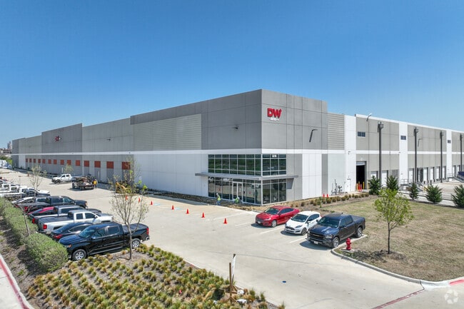

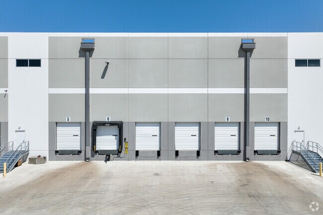
Property Detail
Chaparral Pkwy
Dallas-Fort Worth-Arlington, TX
LOT 1R-1 BLK 1 RAILPORT BUSINESS PARK ADDN-REV 43.31 AC
286021
ELLIS
Industrialgeneral
Texas
B and X Area of moderate flood hazard, usually the area between the limits of the 100-year and 500-year floods.
1r-1
2024
43.31 AC
2025
SW Dallas/US 67
060702
Dallas/Ft Worth
514,900 SF
NEARBY LISTINGS FOR SALE OR LEASE
DEMOGRAPHICS near Chaparral Pkwy
1 mile
3 mile
5 mile
2025 Total Population
60
7,693
40,497
2030 Population
74
9,114
47,542
Pop Growth 2025-2030
+ 23.33%
+ 18.47%
+ 17.40%
Average Age
35
35
37
2025 Total Households
18
2,428
13,003
HH Growth 2025-2030
+ 27.78%
+ 18.29%
+ 17.53%
Median Household Inc
$81,250
$99,893
$109,735
Avg Household Size
3.40
3.20
3.00
2025 Avg HH Vehicles
2.00
2.00
2.00
Median Home Value
$287,499
$346,360
$405,039
Median Year Built
2011
2010
2009
Nearby Places
Map Layers
Map Styles
 Street
 Aerial
Layers
 Traffic
 Biking
Places
Listings with unknown addresses are not visible on the map
- Restaurants
- Banks
- Shops
- Fitness
- Groceries
PUBLIC TRANSPORTATION
AIRPORT
Dallas Love Field
Drive
Walk
Distance
Dallas Love Field
45 min
34.6 mi
Freight Ports
Port of Shreveport
Drive
Walk
Distance
Port of Shreveport
235 min
219.0 mi
SALE & LEASE HISTORY
LISTING DATE
SALE/LEASE

Mar 31, 2021
For Lease
Nearby Properties
Address
Land Use
TOTAL SIZE
Lot Size
Zoning
Address
Land Use
TOTAL SIZE
Lot Size
Zoning
913,952 SF
350.98 AC
Address
Land Use
TOTAL SIZE
Lot Size
Zoning
1,100,000 SF
70.54 AC
Address
Land Use
TOTAL SIZE
Lot Size
Zoning
847,325 SF
93.85 AC
Address
Land Use
TOTAL SIZE
Lot Size
Zoning
740,870 SF
73.29 AC
Address
Land Use
TOTAL SIZE
Lot Size
Zoning
1,350,000 SF
124 AC
Address
Land Use
TOTAL SIZE
Lot Size
Zoning
347,406 SF
20.99 AC
Address
Land Use
TOTAL SIZE
Lot Size
Zoning
422,057 SF
61.86 AC
Address
Land Use
TOTAL SIZE
Lot Size
Zoning
275,423 SF
29.67 AC
Address
Land Use
TOTAL SIZE
Lot Size
Zoning
730,356 SF
44.50 AC
Address
Land Use
TOTAL SIZE
Lot Size
Zoning
309,069 SF
12.33 AC
Address
Land Use
TOTAL SIZE
Lot Size
Zoning
317,100 SF
48.84 AC
Address
Land Use
TOTAL SIZE
Lot Size
Zoning
306,925 SF
19.44 AC
Address
Land Use
TOTAL SIZE
Lot Size
Zoning
80,938 SF
535.62 AC
Address
Land Use
TOTAL SIZE
Lot Size
Zoning
182,484 SF
9.72 AC
Address
Land Use
TOTAL SIZE
Lot Size
Zoning
179,687 SF
22 AC
Address
Land Use
TOTAL SIZE
Lot Size
Zoning
160,775 SF
14.41 AC
Address
Land Use
TOTAL SIZE
Lot Size
Zoning
161,006 SF
10.59 AC
Address
Land Use
TOTAL SIZE
Lot Size
Zoning
756 AC
Address
Land Use
TOTAL SIZE
Lot Size
Zoning
84,902 SF
66 AC
Address
Land Use
TOTAL SIZE
Lot Size
Zoning
100,122 SF
6.52 AC
Address
Land Use
TOTAL SIZE
Lot Size
Zoning
62,274 SF
25.70 AC
Address
Land Use
TOTAL SIZE
Lot Size
Zoning
61.58 AC
Address
Land Use
TOTAL SIZE
Lot Size
Zoning
106,935 SF
31.31 AC
Address
Land Use
TOTAL SIZE
Lot Size
Zoning
315.59 AC
Address
Land Use
TOTAL SIZE
Lot Size
Zoning
87.82 AC
Address
Land Use
TOTAL SIZE
Lot Size
Zoning
27,288 SF
9.34 AC
Address
Land Use
TOTAL SIZE
Lot Size
Zoning
27,954 SF
419.02 AC
Address
Land Use
TOTAL SIZE
Lot Size
Zoning
34.33 AC
Address
Land Use
TOTAL SIZE
Lot Size
Zoning
12,166 SF
4.99 AC
The World's #1 Commercial Real Estate Marketplace
Connect with us
© 2026 CoStar Group
The information above has been obtained from sources believed reliable. While we do not doubt its accuracy we have not verified it and make no guarantee, warranty or representation about it. It is your responsibility to independently confirm its accuracy and completeness. Any projections, opinions, assumptions, or estimates used are for example only and do not represent the current or future performance of the property. The value of this transaction to you depends on tax and other factors which should be evaluated by your tax, financial, and legal advisors. You and your advisors should conduct a careful, independent investigation of the property to determine to your satisfaction the suitability of the property for your needs.