Property Record
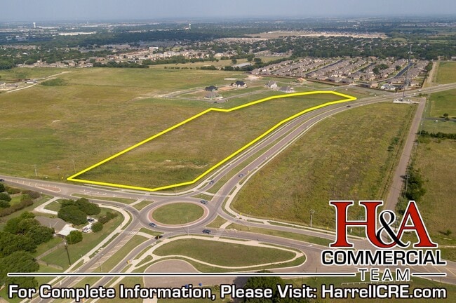
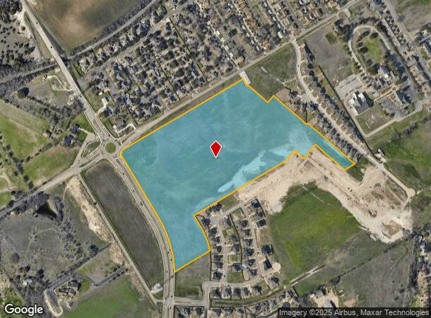
Chapel Rd, Woodway, TX 76712

NEARBY LISTINGS FOR SALE OR LEASE
Property Detail
Chapel Rd
Waco, TX
Rhodes B
36-075900-000401-0
RHODES B ACRES 37.936
Miscellaneous
Mclennan
X
Texas
48309C0530D
37.94 AC
2024
Waco & Killeen
2025
Other Market Areas
002504
DEMOGRAPHICS near Chapel Rd
1 Mile
3 Mile
5 Mile
2024 Total Population
7,286
36,209
70,135
2029 Population
7,777
38,425
74,265
Pop Growth 2024-2029
+ 6.74%
+ 6.12%
+ 5.89%
Average Age
38
41
40
2024 Total Households
2,922
13,533
27,251
HH Growth 2024-2029
+ 6.71%
+ 6.21%
+ 6.01%
Median Household Inc
$79,286
$87,599
$76,796
Avg Household Size
2.40
2.50
2.50
2024 Avg HH Vehicles
2.00
2.00
2.00
Median Home Value
$254,776
$249,742
$249,233
Median Year Built
1995
1990
1987
Nearby Places
Map Layers
Map Styles
 Street
 Aerial
- Restaurants
- Banks
- Shops
- Fitness
- Groceries
PUBLIC TRANSPORTATION
AIRPORT
Waco Regional
DRIVE
WALK
Distance
Waco Regional
30 min
15.2 mi
Freight Ports
Port of Houston
DRIVE
WALK
Distance
Port of Houston
225 min
195.6 mi
Nearby Properties
Address
Land Use
TOTAL SIZE
Lot Size
Zoning
Address
Land Use
TOTAL SIZE
Lot Size
Zoning
Address
Land Use
TOTAL SIZE
Lot Size
Zoning
108,521 SF
70.78 AC
Address
Land Use
TOTAL SIZE
Lot Size
Zoning
106.92 AC
Address
Land Use
TOTAL SIZE
Lot Size
Zoning
752,540 SF
96.04 AC
M-2
Address
Land Use
TOTAL SIZE
Lot Size
Zoning
279,135 SF
13 AC
Address
Land Use
TOTAL SIZE
Lot Size
Zoning
Address
Land Use
TOTAL SIZE
Lot Size
Zoning
Address
Land Use
TOTAL SIZE
Lot Size
Zoning
405,640 SF
64.46 AC
Address
Land Use
TOTAL SIZE
Lot Size
Zoning
459,747 SF
36.13 AC
M2
Address
Land Use
TOTAL SIZE
Lot Size
Zoning
222,388 SF
10.68 AC
R-3C
Address
Land Use
TOTAL SIZE
Lot Size
Zoning
221,876 SF
12.26 AC
C-2
Address
Land Use
TOTAL SIZE
Lot Size
Zoning
Address
Land Use
TOTAL SIZE
Lot Size
Zoning
108,969 SF
24.73 AC
R-1
Address
Land Use
TOTAL SIZE
Lot Size
Zoning
99,179 SF
54.16 AC
R1
Address
Land Use
TOTAL SIZE
Lot Size
Zoning
Address
Land Use
TOTAL SIZE
Lot Size
Zoning
87,492 SF
29.99 AC
R1
Address
Land Use
TOTAL SIZE
Lot Size
Zoning
69,600 SF
2 AC
Address
Land Use
TOTAL SIZE
Lot Size
Zoning
198,670 SF
10.24 AC
M1
Address
Land Use
TOTAL SIZE
Lot Size
Zoning
174,456 SF
9.04 AC
R3C
Address
Land Use
TOTAL SIZE
Lot Size
Zoning
212,934 SF
21.91 AC
C3
Address
Land Use
TOTAL SIZE
Lot Size
Zoning
72,920 SF
11 AC
C-3
Address
Land Use
TOTAL SIZE
Lot Size
Zoning
Address
Land Use
TOTAL SIZE
Lot Size
Zoning
Address
Land Use
TOTAL SIZE
Lot Size
Zoning
86,014 SF
11.87 AC
R1
Address
Land Use
TOTAL SIZE
Lot Size
Zoning
134,265 SF
13.50 AC
M2
Address
Land Use
TOTAL SIZE
Lot Size
Zoning
82.98 AC
M-2
Address
Land Use
TOTAL SIZE
Lot Size
Zoning
65,016 SF
5.08 AC
C-2
Address
Land Use
TOTAL SIZE
Lot Size
Zoning
80,437 SF
30.43 AC
C
Address
Land Use
TOTAL SIZE
Lot Size
Zoning
114,575 SF
4.20 AC
Address
Land Use
TOTAL SIZE
Lot Size
Zoning
156,531 SF
7.51 AC
R-4
The World's #1 Commercial Real Estate Marketplace
Connect with us
© 2025 CoStar Group
The information above has been obtained from sources believed reliable. While we do not doubt its accuracy we have not verified it and make no guarantee, warranty or representation about it. It is your responsibility to independently confirm its accuracy and completeness. Any projections, opinions, assumptions, or estimates used are for example only and do not represent the current or future performance of the property. The value of this transaction to you depends on tax and other factors which should be evaluated by your tax, financial, and legal advisors. You and your advisors should conduct a careful, independent investigation of the property to determine to your satisfaction the suitability of the property for your needs.