Property Record
Charlie Cooper Rd, Braselton, GA 30517

NEARBY LISTINGS FOR SALE OR LEASE
Property Detail
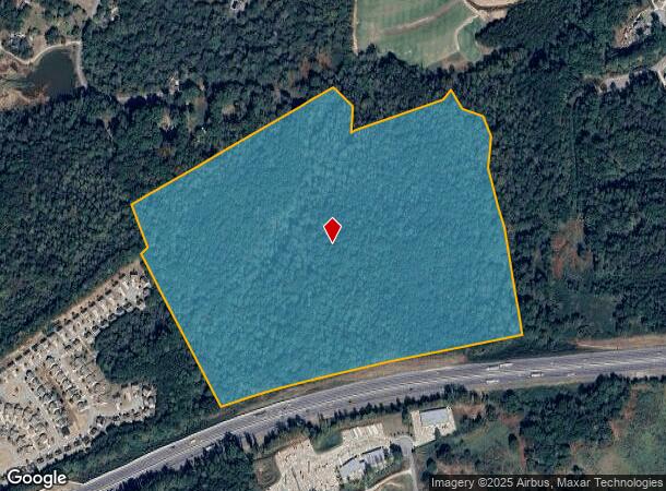
Charlie Cooper Rd
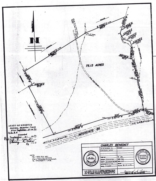
111-008B
PART OF 73.15 AC TRACT ON PLAT BK 9 PG 21
Privatepreserveopenspacevacantlandforestlandconservation
Jackson
AE
Georgia
13139C0350G
72.89 AC
2025
Jackson County
2024
Atlanta
010109
Jefferson, GA
DEMOGRAPHICS near Charlie Cooper Rd
1 Mile
3 Mile
5 Mile
2024 Total Population
1,422
11,705
35,006
2029 Population
1,805
14,977
43,635
Pop Growth 2024-2029
+ 26.93%
+ 27.95%
+ 24.65%
Average Age
38
39
38
2024 Total Households
498
3,927
11,565
HH Growth 2024-2029
+ 25.50%
+ 26.46%
+ 23.42%
Median Household Inc
$56,136
$72,519
$91,391
Avg Household Size
2.80
2.90
3.00
2024 Avg HH Vehicles
2.00
2.00
2.00
Median Home Value
$271,738
$319,279
$336,237
Median Year Built
2007
2004
2005
Nearby Places
Map Layers
Map Styles
 Street
 Aerial
- Restaurants
- Banks
- Shops
- Fitness
- Groceries
SALE & LEASE HISTORY
LISTING DATE
SALE/LEASE

Nov 12, 2019
For Sale
Nearby Properties
Address
Land Use
TOTAL SIZE
Lot Size
Zoning
Address
Land Use
TOTAL SIZE
Lot Size
Zoning
341,330 SF
71.15 AC
001
Address
Land Use
TOTAL SIZE
Lot Size
Zoning
750 SF
001
Address
Land Use
TOTAL SIZE
Lot Size
Zoning
613,440 SF
50 AC
003
Address
Land Use
TOTAL SIZE
Lot Size
Zoning
348,990 SF
86.93 AC
M
Address
Land Use
TOTAL SIZE
Lot Size
Zoning
502,088 SF
36.80 AC
MD
Address
Land Use
TOTAL SIZE
Lot Size
Zoning
462,000 SF
30.12 AC
M1
Address
Land Use
TOTAL SIZE
Lot Size
Zoning
446,439 SF
30.47 AC
003
Address
Land Use
TOTAL SIZE
Lot Size
Zoning
500,500 SF
53.92 AC
MI
Address
Land Use
TOTAL SIZE
Lot Size
Zoning
438,375 SF
32.69 AC
Address
Land Use
TOTAL SIZE
Lot Size
Zoning
209,040 SF
39.07 AC
MD
Address
Land Use
TOTAL SIZE
Lot Size
Zoning
805,954 SF
52.41 AC
003
Address
Land Use
TOTAL SIZE
Lot Size
Zoning
547,250 SF
47.51 AC
M1
Address
Land Use
TOTAL SIZE
Lot Size
Zoning
360,290 SF
35.90 AC
C
Address
Land Use
TOTAL SIZE
Lot Size
Zoning
222,000 SF
20.59 AC
003
Address
Land Use
TOTAL SIZE
Lot Size
Zoning
71,246 SF
10.10 AC
001
Address
Land Use
TOTAL SIZE
Lot Size
Zoning
131,875 SF
18.93 AC
C
Address
Land Use
TOTAL SIZE
Lot Size
Zoning
28,282 SF
6.36 AC
C2
Address
Land Use
TOTAL SIZE
Lot Size
Zoning
146,571 SF
21.60 AC
E2
Address
Land Use
TOTAL SIZE
Lot Size
Zoning
60,128 SF
2.48 AC
001
Address
Land Use
TOTAL SIZE
Lot Size
Zoning
128,874 SF
11.57 AC
001
Address
Land Use
TOTAL SIZE
Lot Size
Zoning
224.76 AC
004
Address
Land Use
TOTAL SIZE
Lot Size
Zoning
56,085 SF
R3
Address
Land Use
TOTAL SIZE
Lot Size
Zoning
81,900 SF
8.61 AC
001
Address
Land Use
TOTAL SIZE
Lot Size
Zoning
20,634 SF
9.80 AC
003
Address
Land Use
TOTAL SIZE
Lot Size
Zoning
35.12 AC
001
Address
Land Use
TOTAL SIZE
Lot Size
Zoning
44,870 SF
11.78 AC
M1
Address
Land Use
TOTAL SIZE
Lot Size
Zoning
10.96 AC
004
Address
Land Use
TOTAL SIZE
Lot Size
Zoning
22.23 AC
001
Address
Land Use
TOTAL SIZE
Lot Size
Zoning
5.95 AC
CRC
Address
Land Use
TOTAL SIZE
Lot Size
Zoning
10.34 AC
CRC
The World's #1 Commercial Real Estate Marketplace
Connect with us
© 2025 CoStar Group
The information above has been obtained from sources believed reliable. While we do not doubt its accuracy we have not verified it and make no guarantee, warranty or representation about it. It is your responsibility to independently confirm its accuracy and completeness. Any projections, opinions, assumptions, or estimates used are for example only and do not represent the current or future performance of the property. The value of this transaction to you depends on tax and other factors which should be evaluated by your tax, financial, and legal advisors. You and your advisors should conduct a careful, independent investigation of the property to determine to your satisfaction the suitability of the property for your needs.