Property Record
Cherry Hill Rd, Canton, MI 48187


This Property Is For Sale
Property Detail
Cherry Hill Rd
Detroit-Warren-Dearborn, MI
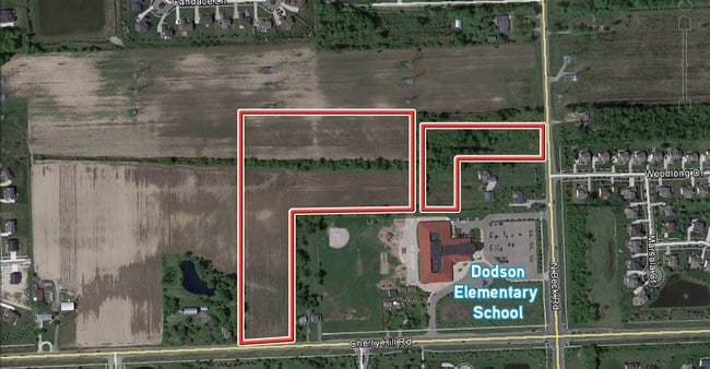
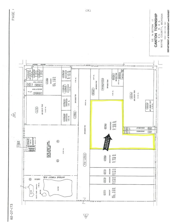
17EE4B SW 1/4 OF SE 1/4 OF SEC 17 T2S R8E EXC W 31ACRES ALSO NW 1/4 OF SE 1/4 OF SE 1/4 OF SEC 17 19.45 AC
71-068-99-0007-002
WAYNE
Residentialacreage
Michigan
RR
0007
B and X Area of moderate flood hazard, usually the area between the limits of the 100-year and 500-year floods.
19.23 AC
2025
Southern I-275 Corridor
2025
Detroit
563600
NEARBY LISTINGS FOR SALE OR LEASE
DEMOGRAPHICS near Cherry Hill Rd
1 mile
3 mile
5 mile
2024 Total Population
8,259
64,472
136,181
2029 Population
8,211
63,651
134,169
Pop Growth 2024-2029
(0.58%)
(1.27%)
(1.48%)
Average Age
38
40
41
2024 Total Households
2,478
22,779
51,462
HH Growth 2024-2029
(0.28%)
(1.25%)
(1.48%)
Median Household Inc
$194,815
$135,249
$112,501
Avg Household Size
3.20
2.80
2.60
2024 Avg HH Vehicles
2.00
2.00
2.00
Median Home Value
$594,539
$385,744
$357,464
Median Year Built
2003
1994
1987
Nearby Places
Map Layers
Map Styles
 Street
 Aerial
Transit
 Traffic
 Biking
Places
Listings with unknown addresses are not visible on the map
- Restaurants
- Banks
- Shops
- Fitness
- Groceries
PUBLIC TRANSPORTATION
AIRPORT
Detroit Metro Wayne County
Drive
Walk
Distance
Detroit Metro Wayne County
24 min
16.2 mi
Windsor International
Drive
Walk
Distance
Windsor International
62 min
41.2 mi
Freight Ports
Port of Toledo
Drive
Walk
Distance
Port of Toledo
73 min
57.8 mi
Nearby Properties
Address
Land Use
TOTAL SIZE
Lot Size
Zoning
Address
Land Use
TOTAL SIZE
Lot Size
Zoning
17.50 AC
R-2
Address
Land Use
TOTAL SIZE
Lot Size
Zoning
176,796 SF
17.08 AC
C-2
Address
Land Use
TOTAL SIZE
Lot Size
Zoning
24.63 AC
MR
Address
Land Use
TOTAL SIZE
Lot Size
Zoning
136,775 SF
15.54 AC
C-3
Address
Land Use
TOTAL SIZE
Lot Size
Zoning
450,840 SF
32.59 AC
Address
Land Use
TOTAL SIZE
Lot Size
Zoning
206,896 SF
19.49 AC
R-6
Address
Land Use
TOTAL SIZE
Lot Size
Zoning
190,344 SF
18.24 AC
R-6
Address
Land Use
TOTAL SIZE
Lot Size
Zoning
186,967 SF
9.75 AC
Address
Land Use
TOTAL SIZE
Lot Size
Zoning
11.40 AC
MR
Address
Land Use
TOTAL SIZE
Lot Size
Zoning
147,968 SF
16.68 AC
Address
Land Use
TOTAL SIZE
Lot Size
Zoning
78,205 SF
14.66 AC
RR
Address
Land Use
TOTAL SIZE
Lot Size
Zoning
100,098 SF
10.52 AC
C-2
Address
Land Use
TOTAL SIZE
Lot Size
Zoning
73,056 SF
7.44 AC
C-3
Address
Land Use
TOTAL SIZE
Lot Size
Zoning
187,281 SF
26.35 AC
C-2
Address
Land Use
TOTAL SIZE
Lot Size
Zoning
51,550 SF
6.49 AC
O-1
Address
Land Use
TOTAL SIZE
Lot Size
Zoning
85,612 SF
17.66 AC
R-1
Address
Land Use
TOTAL SIZE
Lot Size
Zoning
5.43 AC
R-2
Address
Land Use
TOTAL SIZE
Lot Size
Zoning
14.32 AC
R-6
Address
Land Use
TOTAL SIZE
Lot Size
Zoning
6.44 AC
R-2
Address
Land Use
TOTAL SIZE
Lot Size
Zoning
41.45 AC
C-3
Address
Land Use
TOTAL SIZE
Lot Size
Zoning
10.35 AC
MR
Address
Land Use
TOTAL SIZE
Lot Size
Zoning
97,605 SF
5.46 AC
C-2
Address
Land Use
TOTAL SIZE
Lot Size
Zoning
9.31 AC
MR
Address
Land Use
TOTAL SIZE
Lot Size
Zoning
69,683 SF
9.15 AC
C-1
Address
Land Use
TOTAL SIZE
Lot Size
Zoning
159,983 SF
4.85 AC
G-1
Address
Land Use
TOTAL SIZE
Lot Size
Zoning
86,595 SF
6.04 AC
MRD
Address
Land Use
TOTAL SIZE
Lot Size
Zoning
160,283 SF
10.12 AC
LI-2
Address
Land Use
TOTAL SIZE
Lot Size
Zoning
79,813 SF
6.11 AC
R-2
Address
Land Use
TOTAL SIZE
Lot Size
Zoning
58,135 SF
17.75 AC
RR
Address
Land Use
TOTAL SIZE
Lot Size
Zoning
104,469 SF
14.43 AC
C-2
The World's #1 Commercial Real Estate Marketplace
Connect with us
© 2026 CoStar Group
The information above has been obtained from sources believed reliable. While we do not doubt its accuracy we have not verified it and make no guarantee, warranty or representation about it. It is your responsibility to independently confirm its accuracy and completeness. Any projections, opinions, assumptions, or estimates used are for example only and do not represent the current or future performance of the property. The value of this transaction to you depends on tax and other factors which should be evaluated by your tax, financial, and legal advisors. You and your advisors should conduct a careful, independent investigation of the property to determine to your satisfaction the suitability of the property for your needs.