Property Record
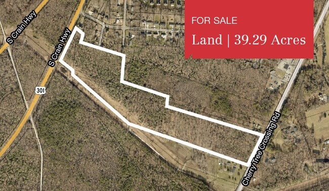
Robert Crain Hwy, Brandywine, MD 20613
NEARBY LISTINGS FOR SALE OR LEASE
Property Detail
Robert Crain Hwy
11-1174721
PT PARCEL 12
Residentialnec
Prince George's
X
Maryland
24033C0355E
1.60 AC
2024
Outlying PG County South
2025
Washington, DC
801003
Washington-Arlington-Alexandria, DC-VA-MD-WV
DEMOGRAPHICS near Robert Crain Hwy
1 mile
3 mile
5 mile
2024 Total Population
1,890
14,102
56,703
2029 Population
1,876
13,940
55,950
Pop Growth 2024-2029
(0.74%)
(1.15%)
(1.33%)
Average Age
42
42
43
2024 Total Households
630
4,814
19,615
HH Growth 2024-2029
(0.79%)
(0.96%)
(1.26%)
Median Household Inc
$136,144
$126,949
$121,869
Avg Household Size
2.90
2.90
2.80
2024 Avg HH Vehicles
2.00
2.00
2.00
Median Home Value
$469,059
$454,857
$400,241
Median Year Built
1997
1998
1989
Nearby Places
Map Layers
Map Styles
 Street
 Aerial
Transit
 Traffic
 Biking
Places
Listings with unknown addresses are not visible on the map
- Restaurants
- Banks
- Shops
- Fitness
- Groceries
PUBLIC TRANSPORTATION
AIRPORT
Ronald Reagan Washington Ntl
Drive
Walk
Distance
Ronald Reagan Washington Ntl
38 min
23.2 mi
Freight Ports
Port of Baltimore
Drive
Walk
Distance
Port of Baltimore
67 min
46.6 mi
SALE & LEASE HISTORY
LISTING DATE
SALE/LEASE

Nov 17, 2020
For Sale
Nearby Properties
Address
Land Use
TOTAL SIZE
Lot Size
Zoning
Address
Land Use
TOTAL SIZE
Lot Size
Zoning
801,684 SF
34.05 AC
IE
Address
Land Use
TOTAL SIZE
Lot Size
Zoning
7,670 SF
9.78 AC
TACC
Address
Land Use
TOTAL SIZE
Lot Size
Zoning
341,372 SF
14.74 AC
RR
Address
Land Use
TOTAL SIZE
Lot Size
Zoning
388,608 SF
28.45 AC
LCD
Address
Land Use
TOTAL SIZE
Lot Size
Zoning
76,906 SF
168.92 AC
AG
Address
Land Use
TOTAL SIZE
Lot Size
Zoning
126,592 SF
58.79 AC
ROS
Address
Land Use
TOTAL SIZE
Lot Size
Zoning
62,838 SF
7.77 AC
TACE
Address
Land Use
TOTAL SIZE
Lot Size
Zoning
67,608 SF
4.01 AC
TACC
Address
Land Use
TOTAL SIZE
Lot Size
Zoning
98.41 AC
IH
Address
Land Use
TOTAL SIZE
Lot Size
Zoning
939.06 AC
RR
Address
Land Use
TOTAL SIZE
Lot Size
Zoning
61,836 SF
9.63 AC
IE
Address
Land Use
TOTAL SIZE
Lot Size
Zoning
1,592.32 AC
ROS
Address
Land Use
TOTAL SIZE
Lot Size
Zoning
54,899 SF
5.23 AC
TACE
Address
Land Use
TOTAL SIZE
Lot Size
Zoning
128,909 SF
10.77 AC
TACE
Address
Land Use
TOTAL SIZE
Lot Size
Zoning
62,442 SF
4.84 AC
TACE
Address
Land Use
TOTAL SIZE
Lot Size
Zoning
28,508 SF
10 AC
TACC
Address
Land Use
TOTAL SIZE
Lot Size
Zoning
19,527 SF
9.50 AC
RR
Address
Land Use
TOTAL SIZE
Lot Size
Zoning
61,125 SF
10.10 AC
TACE
Address
Land Use
TOTAL SIZE
Lot Size
Zoning
127,206 SF
2.90 AC
TACE
Address
Land Use
TOTAL SIZE
Lot Size
Zoning
64.47 AC
IH
Address
Land Use
TOTAL SIZE
Lot Size
Zoning
48,146 SF
4.48 AC
RR
Address
Land Use
TOTAL SIZE
Lot Size
Zoning
87 AC
IH
Address
Land Use
TOTAL SIZE
Lot Size
Zoning
137,226 SF
25.66 AC
RR
Address
Land Use
TOTAL SIZE
Lot Size
Zoning
28.84 AC
IH
Address
Land Use
TOTAL SIZE
Lot Size
Zoning
48,100 SF
6.49 AC
TACC
Address
Land Use
TOTAL SIZE
Lot Size
Zoning
24,570 SF
39.87 AC
IE
Address
Land Use
TOTAL SIZE
Lot Size
Zoning
21,720 SF
10 AC
RR
Address
Land Use
TOTAL SIZE
Lot Size
Zoning
152,431 SF
11.12 AC
RR
Address
Land Use
TOTAL SIZE
Lot Size
Zoning
25.21 AC
IE
Address
Land Use
TOTAL SIZE
Lot Size
Zoning
81,602 SF
28.57 AC
IH
The World's #1 Commercial Real Estate Marketplace
Connect with us
© 2026 CoStar Group
The information above has been obtained from sources believed reliable. While we do not doubt its accuracy we have not verified it and make no guarantee, warranty or representation about it. It is your responsibility to independently confirm its accuracy and completeness. Any projections, opinions, assumptions, or estimates used are for example only and do not represent the current or future performance of the property. The value of this transaction to you depends on tax and other factors which should be evaluated by your tax, financial, and legal advisors. You and your advisors should conduct a careful, independent investigation of the property to determine to your satisfaction the suitability of the property for your needs.