Property Record
Chert Rock, Wimauma, FL 33598
Property Detail
Chert Rock
Tampa-St. Petersburg-Clearwater, FL
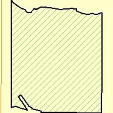
COMM AT SE COR OF NW 1/4 OF SEC 13 THN N 89 DEG 17 MIN 46 SEC W ALONG S BDRY OF NW 1/4 300.00 FT THN N 00 DEG 24 MIN 00 SEC E 25.00 FT TO POB THN N 89 DEG 17 MIN 48 SEC W 1328.09 FT THN N 05 DEG 09 MIN 11 SEC E 24.69 FT THN N 75 DEG 54 MIN 09 SEC W 9
U-13-32-20-ZZZ-000003-22480.1
HILLSBOROUGH
Vacantlandnec
Florida
AR
22480
AE The base floodplain where base flood elevations are provided. AE Zones are now used on new format FIRMs instead of A1-A30 Zones.
96.22 AC
2024
Eastern Outlying
2025
Tampa/St Petersburg
013914
NEARBY LISTINGS FOR SALE OR LEASE
DEMOGRAPHICS near Chert Rock
1 mile
3 mile
5 mile
2025 Total Population
68
3,156
28,909
2030 Population
77
3,500
32,359
Pop Growth 2025-2030
+ 13.24%
+ 10.90%
+ 11.93%
Average Age
40
35
42
2025 Total Households
22
878
9,827
HH Growth 2025-2030
+ 18.18%
+ 11.28%
+ 11.61%
Median Household Inc
$101,389
$66,445
$83,686
Avg Household Size
3.00
3.30
2.80
2025 Avg HH Vehicles
3.00
2.00
2.00
Median Home Value
$366,666
$408,951
$413,770
Median Year Built
1997
2006
2010
Nearby Places
Map Layers
Map Styles
 Street
 Aerial
Transit
 Traffic
 Biking
Places
Listings with unknown addresses are not visible on the map
- Restaurants
- Banks
- Shops
- Fitness
- Groceries
PUBLIC TRANSPORTATION
AIRPORT
Tampa International
Drive
Walk
Distance
Tampa International
57 min
36.4 mi
Sarasota/Bradenton International
Drive
Walk
Distance
Sarasota/Bradenton International
57 min
36.5 mi
St Pete-Clearwater International
Drive
Walk
Distance
St Pete-Clearwater International
74 min
45.7 mi
Freight Ports
Port Manatee
Drive
Walk
Distance
Port Manatee
35 min
21.0 mi
Nearby Properties
Address
Land Use
TOTAL SIZE
Lot Size
Zoning
Address
Land Use
TOTAL SIZE
Lot Size
Zoning
2,051.62 AC
AR
Address
Land Use
TOTAL SIZE
Lot Size
Zoning
737.49 AC
AM
Address
Land Use
TOTAL SIZE
Lot Size
Zoning
8,897 SF
430.30 AC
AR
Address
Land Use
TOTAL SIZE
Lot Size
Zoning
543.83 AC
AM
Address
Land Use
TOTAL SIZE
Lot Size
Zoning
675.65 AC
A
Address
Land Use
TOTAL SIZE
Lot Size
Zoning
3,010 SF
486.85 AC
AM
Address
Land Use
TOTAL SIZE
Lot Size
Zoning
165.08 AC
PD
Address
Land Use
TOTAL SIZE
Lot Size
Zoning
624 SF
359.68 AC
AR
Address
Land Use
TOTAL SIZE
Lot Size
Zoning
227.78 AC
AR
Address
Land Use
TOTAL SIZE
Lot Size
Zoning
3,072 SF
250.91 AC
AR
Address
Land Use
TOTAL SIZE
Lot Size
Zoning
2,686 SF
83.76 AC
AM
Address
Land Use
TOTAL SIZE
Lot Size
Zoning
226.49 AC
AR
Address
Land Use
TOTAL SIZE
Lot Size
Zoning
88,007 SF
11.63 AC
RSC-2
Address
Land Use
TOTAL SIZE
Lot Size
Zoning
178.64 AC
PD
Address
Land Use
TOTAL SIZE
Lot Size
Zoning
56.47 AC
PD
Address
Land Use
TOTAL SIZE
Lot Size
Zoning
77,067 SF
5 AC
AR
Address
Land Use
TOTAL SIZE
Lot Size
Zoning
1,152 SF
276.54 AC
AR
Address
Land Use
TOTAL SIZE
Lot Size
Zoning
155.18 AC
AR
Address
Land Use
TOTAL SIZE
Lot Size
Zoning
185.11 AC
A
Address
Land Use
TOTAL SIZE
Lot Size
Zoning
48,360 SF
4.56 AC
PD
Address
Land Use
TOTAL SIZE
Lot Size
Zoning
23.56 AC
PD
Address
Land Use
TOTAL SIZE
Lot Size
Zoning
7,674 SF
5.50 AC
RSC-6
Address
Land Use
TOTAL SIZE
Lot Size
Zoning
52,942 SF
8.52 AC
RMC-9
Address
Land Use
TOTAL SIZE
Lot Size
Zoning
9,047 SF
1.51 AC
PD
Address
Land Use
TOTAL SIZE
Lot Size
Zoning
17,441 SF
6.31 AC
PD
Address
Land Use
TOTAL SIZE
Lot Size
Zoning
17,812 SF
27.25 AC
AR
Address
Land Use
TOTAL SIZE
Lot Size
Zoning
64.12 AC
PD
Address
Land Use
TOTAL SIZE
Lot Size
Zoning
56.45 AC
PD
Address
Land Use
TOTAL SIZE
Lot Size
Zoning
12,347 SF
1.33 AC
RSC-6
Address
Land Use
TOTAL SIZE
Lot Size
Zoning
33,363 SF
6.56 AC
RMC-6
The World's #1 Commercial Real Estate Marketplace
Connect with us
© 2026 CoStar Group
The information above has been obtained from sources believed reliable. While we do not doubt its accuracy we have not verified it and make no guarantee, warranty or representation about it. It is your responsibility to independently confirm its accuracy and completeness. Any projections, opinions, assumptions, or estimates used are for example only and do not represent the current or future performance of the property. The value of this transaction to you depends on tax and other factors which should be evaluated by your tax, financial, and legal advisors. You and your advisors should conduct a careful, independent investigation of the property to determine to your satisfaction the suitability of the property for your needs.