Property Record
31891 Highway 83 Dr, Warsaw, MO 65355
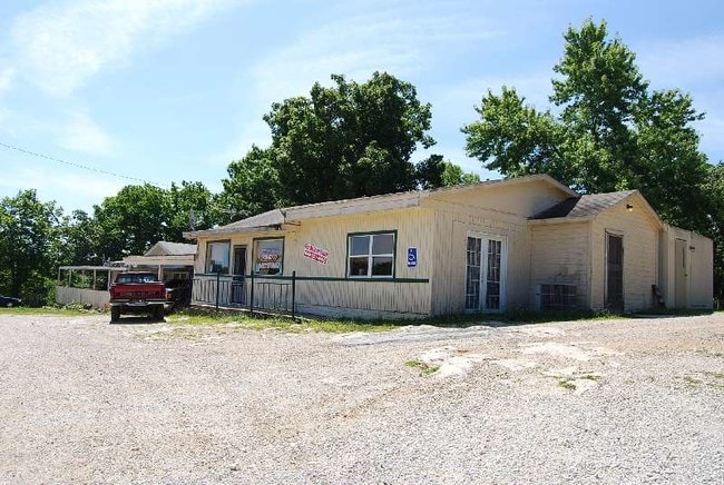

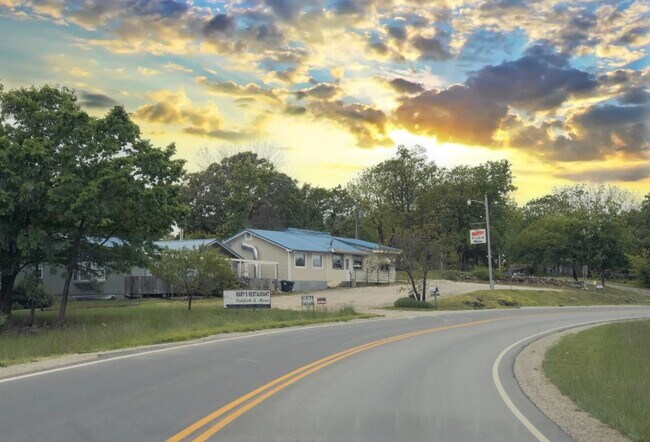
Property Detail
31891 Highway 83 Dr
14-5.0-22-003-010-003.000
PT S1/2 OF SW1/4 LYING W OF OLD STATE HWY 65 & E OF ARTS DEVELOPMENT
Warehouse
BENTON
B and X Area of moderate flood hazard, usually the area between the limits of the 100-year and 500-year floods.
Missouri
2025
3.80 AC
2025
Missouri South Central Area
460802
Other Market Areas
2,240 SF
NEARBY LISTINGS FOR SALE OR LEASE
-
-
View all Warsaw listings for sale on LoopNet.com
DEMOGRAPHICS near 31891 Highway 83 Dr
1 mile
3 mile
5 mile
2025 Total Population
739
3,810
5,758
2030 Population
780
3,880
5,931
Pop Growth 2025-2030
+ 5.55%
+ 1.84%
+ 3.00%
Average Age
49
46
48
2025 Total Households
333
1,670
2,538
HH Growth 2025-2030
+ 5.11%
+ 1.38%
+ 2.68%
Median Household Inc
$39,014
$41,500
$43,776
Avg Household Size
2.20
2.20
2.20
2025 Avg HH Vehicles
2.00
2.00
2.00
Median Home Value
$162,499
$160,950
$176,398
Median Year Built
1986
1980
1984
Nearby Places
Map Layers
Map Styles
 Street
 Aerial
Layers
 Traffic
 Biking
Places
Listings with unknown addresses are not visible on the map
- Restaurants
- Banks
- Shops
- Fitness
- Groceries
SALE & LEASE HISTORY
LISTING DATE
SALE/LEASE

Jan 14, 2020
For Sale
Nearby Properties
Address
Land Use
TOTAL SIZE
Lot Size
Zoning
Address
Land Use
TOTAL SIZE
Lot Size
Zoning
8.01 AC
Address
Land Use
TOTAL SIZE
Lot Size
Zoning
Address
Land Use
TOTAL SIZE
Lot Size
Zoning
18,254 SF
3.09 AC
Address
Land Use
TOTAL SIZE
Lot Size
Zoning
7,140 SF
7 AC
Address
Land Use
TOTAL SIZE
Lot Size
Zoning
9,600 SF
1.50 AC
Address
Land Use
TOTAL SIZE
Lot Size
Zoning
3,410 SF
0.49 AC
Address
Land Use
TOTAL SIZE
Lot Size
Zoning
39,408 SF
3.80 AC
Address
Land Use
TOTAL SIZE
Lot Size
Zoning
8,202 SF
2 AC
Address
Land Use
TOTAL SIZE
Lot Size
Zoning
Address
Land Use
TOTAL SIZE
Lot Size
Zoning
25,100 SF
4.40 AC
Address
Land Use
TOTAL SIZE
Lot Size
Zoning
5,520 SF
9.50 AC
Address
Land Use
TOTAL SIZE
Lot Size
Zoning
27,895 SF
2.80 AC
Address
Land Use
TOTAL SIZE
Lot Size
Zoning
1.20 AC
Address
Land Use
TOTAL SIZE
Lot Size
Zoning
8,624 SF
2.10 AC
Address
Land Use
TOTAL SIZE
Lot Size
Zoning
1.90 AC
Address
Land Use
TOTAL SIZE
Lot Size
Zoning
4,400 SF
2.57 AC
Address
Land Use
TOTAL SIZE
Lot Size
Zoning
752 SF
1.19 AC
Address
Land Use
TOTAL SIZE
Lot Size
Zoning
4,200 SF
1.80 AC
Address
Land Use
TOTAL SIZE
Lot Size
Zoning
3,780 SF
1.10 AC
Address
Land Use
TOTAL SIZE
Lot Size
Zoning
8,400 SF
0.44 AC
Address
Land Use
TOTAL SIZE
Lot Size
Zoning
150 SF
5.80 AC
Address
Land Use
TOTAL SIZE
Lot Size
Zoning
3,455 SF
1.80 AC
Address
Land Use
TOTAL SIZE
Lot Size
Zoning
5,488 SF
1.12 AC
Address
Land Use
TOTAL SIZE
Lot Size
Zoning
6,100 SF
2.80 AC
Address
Land Use
TOTAL SIZE
Lot Size
Zoning
1.16 AC
Address
Land Use
TOTAL SIZE
Lot Size
Zoning
2,400 SF
4.50 AC
Address
Land Use
TOTAL SIZE
Lot Size
Zoning
3,168 SF
1.30 AC
Address
Land Use
TOTAL SIZE
Lot Size
Zoning
1,632 SF
1.70 AC
Address
Land Use
TOTAL SIZE
Lot Size
Zoning
3,784 SF
0.61 AC
Address
Land Use
TOTAL SIZE
Lot Size
Zoning
7,920 SF
4.30 AC
The World's #1 Commercial Real Estate Marketplace
Connect with us
© 2026 CoStar Group
The information above has been obtained from sources believed reliable. While we do not doubt its accuracy we have not verified it and make no guarantee, warranty or representation about it. It is your responsibility to independently confirm its accuracy and completeness. Any projections, opinions, assumptions, or estimates used are for example only and do not represent the current or future performance of the property. The value of this transaction to you depends on tax and other factors which should be evaluated by your tax, financial, and legal advisors. You and your advisors should conduct a careful, independent investigation of the property to determine to your satisfaction the suitability of the property for your needs.