Property Record
Chestnut Ln, Matthews, NC 28104
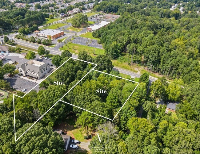

This Property Is For Sale
Property Detail
Chestnut Ln
07-132-010-J
OPCQ769
Commercialacreage
UNION
NBD INDIAN
North Carolina
B and X Area of moderate flood hazard, usually the area between the limits of the 100-year and 500-year floods.
1.24 AC
2025
Union County
2025
Charlotte
020314
Charlotte-Concord-Gastonia, NC-SC
NEARBY LISTINGS FOR SALE OR LEASE
DEMOGRAPHICS near Chestnut Ln
1 mile
3 mile
5 mile
2025 Total Population
7,921
48,935
137,581
2030 Population
8,617
53,421
149,373
Pop Growth 2025-2030
+ 8.79%
+ 9.17%
+ 8.57%
Average Age
40
40
40
2025 Total Households
2,955
17,259
49,575
HH Growth 2025-2030
+ 8.83%
+ 9.37%
+ 8.76%
Median Household Inc
$93,735
$110,350
$114,066
Avg Household Size
2.70
2.80
2.70
2025 Avg HH Vehicles
2.00
2.00
2.00
Median Home Value
$461,958
$473,174
$484,365
Median Year Built
2002
2001
1999
Nearby Places
Map Layers
Map Styles
 Street
 Aerial
Layers
 Traffic
 Biking
Places
Listings with unknown addresses are not visible on the map
- Restaurants
- Banks
- Shops
- Fitness
- Groceries
PUBLIC TRANSPORTATION
AIRPORT
Charlotte/Douglas International
Drive
Walk
Distance
Charlotte/Douglas International
37 min
23.1 mi
Concord-Padgett Regional
Drive
Walk
Distance
Concord-Padgett Regional
38 min
28.5 mi
Nearby Properties
Address
Land Use
TOTAL SIZE
Lot Size
Zoning
Address
Land Use
TOTAL SIZE
Lot Size
Zoning
1,064,632 SF
73.76 AC
Address
Land Use
TOTAL SIZE
Lot Size
Zoning
282,922 SF
47.76 AC
R4
Address
Land Use
TOTAL SIZE
Lot Size
Zoning
18.05 AC
CBD INDIAN
Address
Land Use
TOTAL SIZE
Lot Size
Zoning
28.27 AC
Address
Land Use
TOTAL SIZE
Lot Size
Zoning
3,231 SF
16.89 AC
MFR INDIAN
Address
Land Use
TOTAL SIZE
Lot Size
Zoning
241,703 SF
17.43 AC
R12MFCD
Address
Land Use
TOTAL SIZE
Lot Size
Zoning
227,659 SF
26.46 AC
MFR INDIAN
Address
Land Use
TOTAL SIZE
Lot Size
Zoning
12.30 AC
SF-1 INDIA
Address
Land Use
TOTAL SIZE
Lot Size
Zoning
2,062 SF
105.82 AC
B-1SCD
Address
Land Use
TOTAL SIZE
Lot Size
Zoning
498,729 SF
78.21 AC
RBD INDIAN
Address
Land Use
TOTAL SIZE
Lot Size
Zoning
103,313 SF
12.79 AC
B1SCD
Address
Land Use
TOTAL SIZE
Lot Size
Zoning
8.82 AC
R-20 STALL
Address
Land Use
TOTAL SIZE
Lot Size
Zoning
75,923 SF
7.29 AC
SF-1 INDIA
Address
Land Use
TOTAL SIZE
Lot Size
Zoning
93,040 SF
16.57 AC
GR STALLIN
Address
Land Use
TOTAL SIZE
Lot Size
Zoning
99,213 SF
23.91 AC
R-3
Address
Land Use
TOTAL SIZE
Lot Size
Zoning
209,960 SF
26.64 AC
RBD INDIAN
Address
Land Use
TOTAL SIZE
Lot Size
Zoning
15,539 SF
50.79 AC
Address
Land Use
TOTAL SIZE
Lot Size
Zoning
86,960 SF
14.13 AC
SF-1 INDIA
Address
Land Use
TOTAL SIZE
Lot Size
Zoning
232,678 SF
63 AC
RBD INDIAN
Address
Land Use
TOTAL SIZE
Lot Size
Zoning
74,064 SF
28.17 AC
R20
Address
Land Use
TOTAL SIZE
Lot Size
Zoning
93,098 SF
12 AC
SF-1 INDIA
Address
Land Use
TOTAL SIZE
Lot Size
Zoning
47,362 SF
13.59 AC
NBD INDIAN
Address
Land Use
TOTAL SIZE
Lot Size
Zoning
66,608 SF
9.74 AC
O-1(CD)
Address
Land Use
TOTAL SIZE
Lot Size
Zoning
3,600 SF
9.86 AC
R-40 UNION
Address
Land Use
TOTAL SIZE
Lot Size
Zoning
22,429 SF
6.83 AC
R-20 STALL
Address
Land Use
TOTAL SIZE
Lot Size
Zoning
244,087 SF
15.81 AC
CZ STALLIN
Address
Land Use
TOTAL SIZE
Lot Size
Zoning
47,861 SF
18.65 AC
R-15
Address
Land Use
TOTAL SIZE
Lot Size
Zoning
20,202 SF
3.30 AC
SF-1 INDIA
Address
Land Use
TOTAL SIZE
Lot Size
Zoning
75,951 SF
5.82 AC
LI INDIAN
Address
Land Use
TOTAL SIZE
Lot Size
Zoning
128.83 AC
R-3
The World's #1 Commercial Real Estate Marketplace
Connect with us
© 2026 CoStar Group
The information above has been obtained from sources believed reliable. While we do not doubt its accuracy we have not verified it and make no guarantee, warranty or representation about it. It is your responsibility to independently confirm its accuracy and completeness. Any projections, opinions, assumptions, or estimates used are for example only and do not represent the current or future performance of the property. The value of this transaction to you depends on tax and other factors which should be evaluated by your tax, financial, and legal advisors. You and your advisors should conduct a careful, independent investigation of the property to determine to your satisfaction the suitability of the property for your needs.