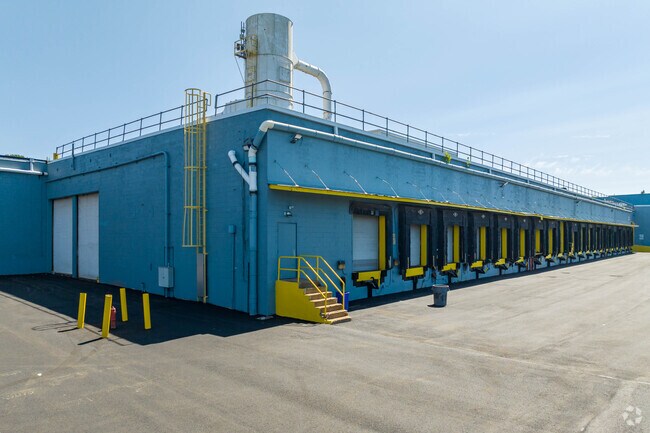
Property Record
Church Rd, , PA

NEARBY LISTINGS FOR SALE OR LEASE
Property Detail
Church Rd
Scranton--Wilkes-Barre--Hazelton, PA
64-62-2-D3-D4-1 CHURCH RD
64-M10-00A-10D-000
Luzerne
Heavymanufacturing
Pennsylvania
X
10d
42079C0369E
12.09 AC
2025
I-81 Corridor
2025
Philadelphia
215503
DEMOGRAPHICS near Church Rd
1 Mile
3 Mile
5 Mile
2024 Total Population
206
10,182
14,451
2029 Population
202
10,109
14,370
Pop Growth 2024-2029
(1.94%)
(0.72%)
(0.56%)
Average Age
44
43
43
2024 Total Households
83
3,869
5,527
HH Growth 2024-2029
(2.41%)
(0.70%)
(0.54%)
Median Household Inc
$94,317
$94,410
$95,890
Avg Household Size
2.50
2.60
2.60
2024 Avg HH Vehicles
3.00
2.00
2.00
Median Home Value
$194,827
$247,530
$244,046
Median Year Built
1958
1978
1980
Nearby Places
Map Layers
Map Styles
 Street
 Aerial
- Restaurants
- Banks
- Shops
- Fitness
- Groceries
PUBLIC TRANSPORTATION
AIRPORT
Wilkes-Barre/Scranton International
DRIVE
WALK
Distance
Wilkes-Barre/Scranton International
36 min
21.2 mi
Freight Ports
Port of Philadelphia
DRIVE
WALK
Distance
Port of Philadelphia
136 min
107.4 mi
SALE & LEASE HISTORY
LISTING DATE
SALE/LEASE

Sep 30, 2021
For Lease
Nov 27, 2023
For Lease
Jun 21, 2019
For Sale
Jun 14, 2023
For Lease
Feb 16, 2021
For Sale
Feb 16, 2021
For Sale
Aug 30, 2023
For Lease
Aug 28, 2023
For Lease
Nearby Properties
Address
Land Use
TOTAL SIZE
Lot Size
Zoning
Address
Land Use
TOTAL SIZE
Lot Size
Zoning
42.17 AC
Address
Land Use
TOTAL SIZE
Lot Size
Zoning
39.19 AC
Address
Land Use
TOTAL SIZE
Lot Size
Zoning
Address
Land Use
TOTAL SIZE
Lot Size
Zoning
26.11 AC
Address
Land Use
TOTAL SIZE
Lot Size
Zoning
18.51 AC
Address
Land Use
TOTAL SIZE
Lot Size
Zoning
37.11 AC
Address
Land Use
TOTAL SIZE
Lot Size
Zoning
42.15 AC
Address
Land Use
TOTAL SIZE
Lot Size
Zoning
28.60 AC
Address
Land Use
TOTAL SIZE
Lot Size
Zoning
27.94 AC
Address
Land Use
TOTAL SIZE
Lot Size
Zoning
38.29 AC
Address
Land Use
TOTAL SIZE
Lot Size
Zoning
24.90 AC
Address
Land Use
TOTAL SIZE
Lot Size
Zoning
22.86 AC
Address
Land Use
TOTAL SIZE
Lot Size
Zoning
19.74 AC
Address
Land Use
TOTAL SIZE
Lot Size
Zoning
28.79 AC
Address
Land Use
TOTAL SIZE
Lot Size
Zoning
20.61 AC
Address
Land Use
TOTAL SIZE
Lot Size
Zoning
20.06 AC
Address
Land Use
TOTAL SIZE
Lot Size
Zoning
14.19 AC
Address
Land Use
TOTAL SIZE
Lot Size
Zoning
10.47 AC
Address
Land Use
TOTAL SIZE
Lot Size
Zoning
3,254.45 AC
Address
Land Use
TOTAL SIZE
Lot Size
Zoning
3,168 SF
15.75 AC
Address
Land Use
TOTAL SIZE
Lot Size
Zoning
Address
Land Use
TOTAL SIZE
Lot Size
Zoning
2.59 AC
Address
Land Use
TOTAL SIZE
Lot Size
Zoning
Address
Land Use
TOTAL SIZE
Lot Size
Zoning
10.09 AC
Address
Land Use
TOTAL SIZE
Lot Size
Zoning
4.39 AC
Address
Land Use
TOTAL SIZE
Lot Size
Zoning
15.01 AC
Address
Land Use
TOTAL SIZE
Lot Size
Zoning
1,207.24 AC
Address
Land Use
TOTAL SIZE
Lot Size
Zoning
33.51 AC
Address
Land Use
TOTAL SIZE
Lot Size
Zoning
13.15 AC
Address
Land Use
TOTAL SIZE
Lot Size
Zoning
13.57 AC
The World's #1 Commercial Real Estate Marketplace
Connect with us
© 2025 CoStar Group
The information above has been obtained from sources believed reliable. While we do not doubt its accuracy we have not verified it and make no guarantee, warranty or representation about it. It is your responsibility to independently confirm its accuracy and completeness. Any projections, opinions, assumptions, or estimates used are for example only and do not represent the current or future performance of the property. The value of this transaction to you depends on tax and other factors which should be evaluated by your tax, financial, and legal advisors. You and your advisors should conduct a careful, independent investigation of the property to determine to your satisfaction the suitability of the property for your needs.