Property Record
Church Rd, Marengo, IL 60152


NEARBY LISTINGS FOR SALE OR LEASE
Property Detail
Church Rd
Chicago-Naperville-Elgin, IL-IN-WI
Memo Division
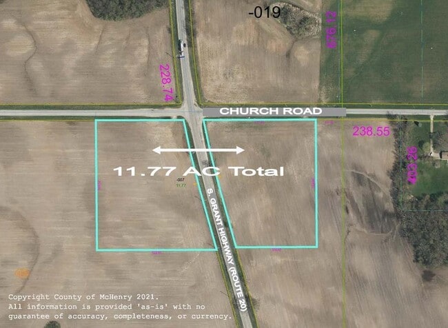
17-28-400-007
DOC 2021R0050902 & 2021R0050901 PT N 567.52FT W OF E 111.98FT N1/2 SE1/4 MEMO: MAJHA BROTHERS LLC-42% INT PER DOC 2021R0050902 & 58% INT PER DOC 2021R0050901
Farms
McHenry
X
Illinois
17089C0020J
11.77 AC
2024
Far Northwest
2024
Chicago
871004
DEMOGRAPHICS near Church Rd
1 Mile
3 Mile
5 Mile
2024 Total Population
1,248
8,758
11,799
2029 Population
1,243
8,791
11,811
Pop Growth 2024-2029
(0.40%)
+ 0.38%
+ 0.10%
Average Age
43
40
41
2024 Total Households
558
3,400
4,529
HH Growth 2024-2029
(0.54%)
+ 0.35%
+ 0.04%
Median Household Inc
$26,081
$73,539
$85,341
Avg Household Size
2.20
2.60
2.60
2024 Avg HH Vehicles
2.00
2.00
2.00
Median Home Value
$214,953
$183,046
$207,037
Median Year Built
1973
1975
1976
Nearby Places
Map Layers
Map Styles
 Street
 Aerial
- Restaurants
- Banks
- Shops
- Fitness
- Groceries
PUBLIC TRANSPORTATION
AIRPORT
Chicago/Rockford International
DRIVE
WALK
Distance
Chicago/Rockford International
51 min
39.1 mi
Freight Ports
Port Milwaukee
DRIVE
WALK
Distance
Port Milwaukee
110 min
82.6 mi
SALE & LEASE HISTORY
LISTING DATE
SALE/LEASE

Apr 01, 2021
For Sale
Nearby Properties
Address
Land Use
TOTAL SIZE
Lot Size
Zoning
Address
Land Use
TOTAL SIZE
Lot Size
Zoning
8.48 AC
Address
Land Use
TOTAL SIZE
Lot Size
Zoning
33.27 AC
Address
Land Use
TOTAL SIZE
Lot Size
Zoning
193,200 SF
23.60 AC
M2 MANUFAC
Address
Land Use
TOTAL SIZE
Lot Size
Zoning
13.24 AC
Address
Land Use
TOTAL SIZE
Lot Size
Zoning
76,458 SF
6.67 AC
M2 MANUFAC
Address
Land Use
TOTAL SIZE
Lot Size
Zoning
19,328 SF
15.27 AC
B1 DISTRIC
Address
Land Use
TOTAL SIZE
Lot Size
Zoning
6,244 SF
3.21 AC
B1 DISTRIC
Address
Land Use
TOTAL SIZE
Lot Size
Zoning
0.50 AC
Address
Land Use
TOTAL SIZE
Lot Size
Zoning
4.28 AC
Address
Land Use
TOTAL SIZE
Lot Size
Zoning
21,206 SF
1.73 AC
B1 DISTRIC
Address
Land Use
TOTAL SIZE
Lot Size
Zoning
5.58 AC
Address
Land Use
TOTAL SIZE
Lot Size
Zoning
15,000 SF
1.30 AC
B1 DISTRIC
Address
Land Use
TOTAL SIZE
Lot Size
Zoning
2.60 AC
B1 DISTRIC
Address
Land Use
TOTAL SIZE
Lot Size
Zoning
Address
Land Use
TOTAL SIZE
Lot Size
Zoning
11.99 AC
Address
Land Use
TOTAL SIZE
Lot Size
Zoning
3,580 SF
1.10 AC
B1 DISTRIC
Address
Land Use
TOTAL SIZE
Lot Size
Zoning
7.49 AC
B1 DISTRIC
Address
Land Use
TOTAL SIZE
Lot Size
Zoning
7,088 SF
69.90 AC
Address
Land Use
TOTAL SIZE
Lot Size
Zoning
68.46 AC
Address
Land Use
TOTAL SIZE
Lot Size
Zoning
2,681 SF
1.19 AC
B1 DISTRIC
Address
Land Use
TOTAL SIZE
Lot Size
Zoning
101.17 AC
Address
Land Use
TOTAL SIZE
Lot Size
Zoning
4,841 SF
5.30 AC
Address
Land Use
TOTAL SIZE
Lot Size
Zoning
4,000 SF
5.50 AC
B1 DISTRIC
Address
Land Use
TOTAL SIZE
Lot Size
Zoning
14,500 SF
8.49 AC
Address
Land Use
TOTAL SIZE
Lot Size
Zoning
3,948 SF
14.24 AC
Address
Land Use
TOTAL SIZE
Lot Size
Zoning
0.50 AC
Address
Land Use
TOTAL SIZE
Lot Size
Zoning
11,520 SF
1.80 AC
B1 DISTRIC
Address
Land Use
TOTAL SIZE
Lot Size
Zoning
38.74 AC
Address
Land Use
TOTAL SIZE
Lot Size
Zoning
6.87 AC
Address
Land Use
TOTAL SIZE
Lot Size
Zoning
4.89 AC
The World's #1 Commercial Real Estate Marketplace
Connect with us
© 2026 CoStar Group
The information above has been obtained from sources believed reliable. While we do not doubt its accuracy we have not verified it and make no guarantee, warranty or representation about it. It is your responsibility to independently confirm its accuracy and completeness. Any projections, opinions, assumptions, or estimates used are for example only and do not represent the current or future performance of the property. The value of this transaction to you depends on tax and other factors which should be evaluated by your tax, financial, and legal advisors. You and your advisors should conduct a careful, independent investigation of the property to determine to your satisfaction the suitability of the property for your needs.