Property Record
Circuit Ct, Sparks, NV 89441
This Property Is For Sale
NEARBY LISTINGS FOR SALE OR LEASE
Property Detail
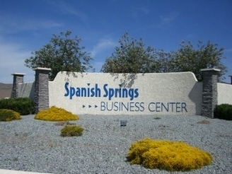
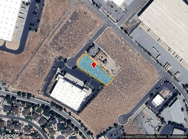
Circuit Ct
Reno, NV
_Unspecified
530-470-31
PM 4319 FR LT B
Industrialacreage
Washoe
X
Nevada
32031C2865G
b
0
1 AC
2026
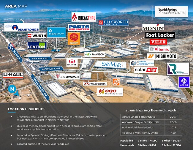
N Outlying Washoe County
003519
Reno/Sparks
DEMOGRAPHICS near Circuit Ct
1 Mile
3 Mile
5 Mile
2024 Total Population
4,770
19,382
42,786
2029 Population
5,161
20,680
45,452
Pop Growth 2024-2029
+ 8.20%
+ 6.70%
+ 6.23%
Average Age
41
43
41
2024 Total Households
1,639
6,998
15,299
HH Growth 2024-2029
+ 8.42%
+ 6.80%
+ 6.37%
Median Household Inc
$140,307
$111,391
$110,719
Avg Household Size
2.90
2.70
2.80
2024 Avg HH Vehicles
3.00
3.00
2.00
Median Home Value
$480,606
$480,352
$480,713
Median Year Built
2008
2001
2004
Nearby Places
- Restaurants
- Banks
- Shops
- Fitness
- Groceries
PUBLIC TRANSPORTATION
AIRPORT
Reno/Tahoe International
DRIVE
WALK
Distance
Reno/Tahoe International
23 min
15.6 mi
Nearby Properties
Address
Land Use
TOTAL SIZE
Lot Size
Zoning
Address
Land Use
TOTAL SIZE
Lot Size
Zoning
349,926 SF
76.09 AC
I
Address
Land Use
TOTAL SIZE
Lot Size
Zoning
602,186 SF
66 AC
I
Address
Land Use
TOTAL SIZE
Lot Size
Zoning
289,637 SF
53.48 AC
PSP
Address
Land Use
TOTAL SIZE
Lot Size
Zoning
238,764 SF
7 AC
NC
Address
Land Use
TOTAL SIZE
Lot Size
Zoning
209,527 SF
5.28 AC
NC
Address
Land Use
TOTAL SIZE
Lot Size
Zoning
160,562 SF
17.10 AC
I
Address
Land Use
TOTAL SIZE
Lot Size
Zoning
464,360 SF
36.05 AC
I
Address
Land Use
TOTAL SIZE
Lot Size
Zoning
419,040 SF
20.67 AC
I
Address
Land Use
TOTAL SIZE
Lot Size
Zoning
408,965 SF
20.44 AC
I
Address
Land Use
TOTAL SIZE
Lot Size
Zoning
412,614 SF
25.93 AC
I
Address
Land Use
TOTAL SIZE
Lot Size
Zoning
188,646 SF
20 AC
I
Address
Land Use
TOTAL SIZE
Lot Size
Zoning
411,100 SF
19.44 AC
I
Address
Land Use
TOTAL SIZE
Lot Size
Zoning
408,660 SF
20.15 AC
I
Address
Land Use
TOTAL SIZE
Lot Size
Zoning
195,000 SF
11.18 AC
I
Address
Land Use
TOTAL SIZE
Lot Size
Zoning
185,000 SF
10 AC
I
Address
Land Use
TOTAL SIZE
Lot Size
Zoning
146,900 SF
10 AC
I
Address
Land Use
TOTAL SIZE
Lot Size
Zoning
55,704 SF
14.03 AC
MDS 1% / O
Address
Land Use
TOTAL SIZE
Lot Size
Zoning
122,223 SF
20 AC
PSP
Address
Land Use
TOTAL SIZE
Lot Size
Zoning
152,640 SF
24.48 AC
I
Address
Land Use
TOTAL SIZE
Lot Size
Zoning
106,387 SF
10.45 AC
I
Address
Land Use
TOTAL SIZE
Lot Size
Zoning
172,500 SF
9.95 AC
I
Address
Land Use
TOTAL SIZE
Lot Size
Zoning
144,000 SF
9.90 AC
I
Address
Land Use
TOTAL SIZE
Lot Size
Zoning
81,122 SF
8.44 AC
NUD
Address
Land Use
TOTAL SIZE
Lot Size
Zoning
121,680 SF
8.82 AC
I
Address
Land Use
TOTAL SIZE
Lot Size
Zoning
173,680 SF
11.23 AC
I
Address
Land Use
TOTAL SIZE
Lot Size
Zoning
61,048 SF
13.10 AC
PSP
Address
Land Use
TOTAL SIZE
Lot Size
Zoning
102,137 SF
8.46 AC
NC
Address
Land Use
TOTAL SIZE
Lot Size
Zoning
13,372.63 AC
OS 45% / G
Address
Land Use
TOTAL SIZE
Lot Size
Zoning
52,128 SF
6.70 AC
GC
Address
Land Use
TOTAL SIZE
Lot Size
Zoning
55,889 SF
9.87 AC
PSP
The World's #1 Commercial Real Estate Marketplace
Connect with us
© 2025 CoStar Group
The information above has been obtained from sources believed reliable. While we do not doubt its accuracy we have not verified it and make no guarantee, warranty or representation about it. It is your responsibility to independently confirm its accuracy and completeness. Any projections, opinions, assumptions, or estimates used are for example only and do not represent the current or future performance of the property. The value of this transaction to you depends on tax and other factors which should be evaluated by your tax, financial, and legal advisors. You and your advisors should conduct a careful, independent investigation of the property to determine to your satisfaction the suitability of the property for your needs.