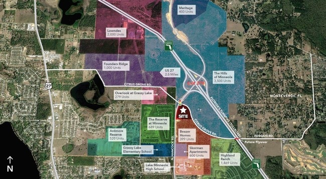
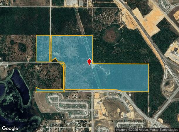
Property Record
Citrus Grove Rd, Minneola, FL 34715
NEARBY LISTINGS FOR SALE OR LEASE
Property Detail
Citrus Grove Rd
Orlando-Kissimmee-Sanford, FL
Acreage
05-22-26-0002-000-01200
S 1/2 OF NW 1/4 N 1/2 OF SW 1/4 N 1/2 OF SE 1/4--LESS RD R/WS & LESS FROM W 1/4 COR OF SEC 5-22-26 RUN S 89-22-25 E 7.28 FT N 0-37-35 E 64.01 FT FOR POB RUN S 89-34-38 E 103.20 FT S 89-34-31 E 397.40 FT TO THE POINT OF CURVATURE OF A CURVE CONCAVE TO
Timberlandforesttreesagricultural
Lake
A
Florida
12095C0200H
12
2024
190.72 AC
2026
Lake County
031309
Orlando
DEMOGRAPHICS near Citrus Grove Rd
1 Mile
3 Mile
5 Mile
2024 Total Population
4,629
33,720
75,342
2029 Population
5,571
39,746
88,525
Pop Growth 2024-2029
+ 20.35%
+ 17.87%
+ 17.50%
Average Age
35
39
41
2024 Total Households
1,431
11,871
27,320
HH Growth 2024-2029
+ 20.20%
+ 17.56%
+ 17.25%
Median Household Inc
$91,287
$82,693
$81,911
Avg Household Size
3.20
2.80
2.70
2024 Avg HH Vehicles
2.00
2.00
2.00
Median Home Value
$342,915
$330,944
$324,676
Median Year Built
2010
2004
2004
Nearby Places
Map Layers
Map Styles
 Street
 Aerial
- Restaurants
- Banks
- Shops
- Fitness
- Groceries
PUBLIC TRANSPORTATION
AIRPORT
Orlando International
DRIVE
WALK
Distance
Orlando International
43 min
33.6 mi
Freight Ports
Port of Tampa Bay
DRIVE
WALK
Distance
Port of Tampa Bay
108 min
80.1 mi
SALE & LEASE HISTORY
LISTING DATE
SALE/LEASE

Sep 12, 2019
For Lease
Nearby Properties
Address
Land Use
TOTAL SIZE
Lot Size
Zoning
Address
Land Use
TOTAL SIZE
Lot Size
Zoning
403,970 SF
30.99 AC
PUD
Address
Land Use
TOTAL SIZE
Lot Size
Zoning
337,218 SF
16.38 AC
Address
Land Use
TOTAL SIZE
Lot Size
Zoning
199.94 AC
PUDR
Address
Land Use
TOTAL SIZE
Lot Size
Zoning
83.86 AC
Address
Land Use
TOTAL SIZE
Lot Size
Zoning
2,000 SF
63.78 AC
Address
Land Use
TOTAL SIZE
Lot Size
Zoning
80,774 SF
6.61 AC
Address
Land Use
TOTAL SIZE
Lot Size
Zoning
128,174 SF
9.88 AC
B1
Address
Land Use
TOTAL SIZE
Lot Size
Zoning
80,546 SF
6.75 AC
B1
Address
Land Use
TOTAL SIZE
Lot Size
Zoning
62,415 SF
10.19 AC
Address
Land Use
TOTAL SIZE
Lot Size
Zoning
74,375 SF
6.69 AC
Address
Land Use
TOTAL SIZE
Lot Size
Zoning
123,387 SF
47.51 AC
R3
Address
Land Use
TOTAL SIZE
Lot Size
Zoning
55,754 SF
9.14 AC
R2
Address
Land Use
TOTAL SIZE
Lot Size
Zoning
2,000 SF
19.45 AC
Address
Land Use
TOTAL SIZE
Lot Size
Zoning
30,926 SF
0.38 AC
Address
Land Use
TOTAL SIZE
Lot Size
Zoning
73,040 SF
4.89 AC
I1
Address
Land Use
TOTAL SIZE
Lot Size
Zoning
40,798 SF
7.51 AC
P
Address
Land Use
TOTAL SIZE
Lot Size
Zoning
102,584 SF
9.21 AC
R3
Address
Land Use
TOTAL SIZE
Lot Size
Zoning
28,836 SF
2.34 AC
Address
Land Use
TOTAL SIZE
Lot Size
Zoning
28,560 SF
9.89 AC
PUD
Address
Land Use
TOTAL SIZE
Lot Size
Zoning
30.07 AC
Address
Land Use
TOTAL SIZE
Lot Size
Zoning
14,106 SF
1.69 AC
RSF2
Address
Land Use
TOTAL SIZE
Lot Size
Zoning
2,000 SF
17.63 AC
P
Address
Land Use
TOTAL SIZE
Lot Size
Zoning
31,018 SF
2.88 AC
B1
Address
Land Use
TOTAL SIZE
Lot Size
Zoning
51,272 SF
4.91 AC
C2
Address
Land Use
TOTAL SIZE
Lot Size
Zoning
36,768 SF
3.59 AC
P
Address
Land Use
TOTAL SIZE
Lot Size
Zoning
23,504 SF
11.97 AC
CFD
Address
Land Use
TOTAL SIZE
Lot Size
Zoning
17,500 SF
2.05 AC
C2
Address
Land Use
TOTAL SIZE
Lot Size
Zoning
14,729 SF
1.95 AC
B1
Address
Land Use
TOTAL SIZE
Lot Size
Zoning
40.73 AC
R1
Address
Land Use
TOTAL SIZE
Lot Size
Zoning
57,187 SF
170.79 AC
HM
The World's #1 Commercial Real Estate Marketplace
Connect with us
© 2025 CoStar Group
The information above has been obtained from sources believed reliable. While we do not doubt its accuracy we have not verified it and make no guarantee, warranty or representation about it. It is your responsibility to independently confirm its accuracy and completeness. Any projections, opinions, assumptions, or estimates used are for example only and do not represent the current or future performance of the property. The value of this transaction to you depends on tax and other factors which should be evaluated by your tax, financial, and legal advisors. You and your advisors should conduct a careful, independent investigation of the property to determine to your satisfaction the suitability of the property for your needs.