Property Record
Vac/Clanfield St/Vic 55Th St W, Acton, CA 93510
This Property Is For Sale
NEARBY LISTINGS FOR SALE OR LEASE
Property Detail
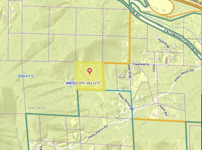
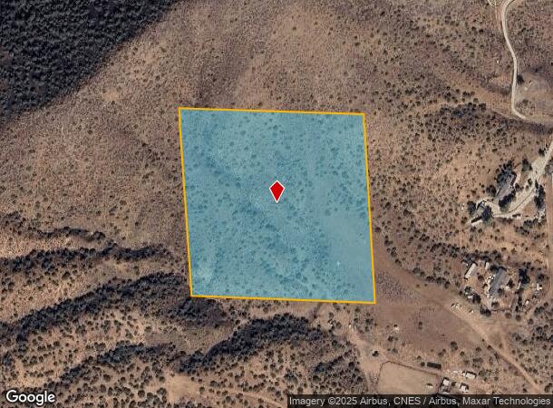
Vac/Clanfield St/Vic 55Th St W
Los Angeles-Long Beach-Glendale, CA
*TR=PARCEL MAP AS PER BK 77 PG 75-76 OF P M LOT 4
3223-004-032
Los Angeles
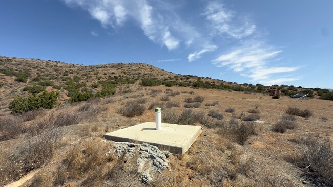
Desertorbarrenland
California
X
4
06037C0880G
10.01 AC
2024
Antelope Valley
2025
Los Angeles
910815
DEMOGRAPHICS near Vac/Clanfield St/Vic 55Th St W
1 Mile
3 Mile
5 Mile
2024 Total Population
218
3,403
8,085
2029 Population
208
3,244
7,755
Pop Growth 2024-2029
(4.59%)
(4.67%)
(4.08%)
Average Age
45
45
46
2024 Total Households
78
1,213
2,896
HH Growth 2024-2029
(5.13%)
(5.11%)
(4.52%)
Median Household Inc
$128,125
$124,710
$117,582
Avg Household Size
2.80
2.80
2.70
2024 Avg HH Vehicles
3.00
3.00
3.00
Median Home Value
$779,069
$780,701
$782,482
Median Year Built
1982
1983
1984
Nearby Places
Map Layers
Map Styles
 Street
 Aerial
- Restaurants
- Banks
- Shops
- Fitness
- Groceries
PUBLIC TRANSPORTATION
COMMUTER RAIL
Vincent Grade/Acton (Antelope Valley Line - Southern California Regional Rail Authority (Metrolink))
DRIVE
WALK
Distance
Vincent Grade/Acton (Antelope Valley Line - Southern California Regional Rail Authority (Metrolink))
12 min
7.7 mi
AIRPORT
Bob Hope
DRIVE
WALK
Distance
Bob Hope
44 min
36.3 mi
Freight Ports
Port of Long Beach
DRIVE
WALK
Distance
Port of Long Beach
87 min
72.7 mi
Nearby Properties
Address
Land Use
TOTAL SIZE
Lot Size
Zoning
Address
Land Use
TOTAL SIZE
Lot Size
Zoning
342,675 SF
9.09 AC
LCC4-R3*
Address
Land Use
TOTAL SIZE
Lot Size
Zoning
35,880 SF
2.89 AC
LCC4
Address
Land Use
TOTAL SIZE
Lot Size
Zoning
39,654 SF
2.28 AC
C4
Address
Land Use
TOTAL SIZE
Lot Size
Zoning
5,010 SF
0.74 AC
LCC4*
Address
Land Use
TOTAL SIZE
Lot Size
Zoning
13,193 SF
5.02 AC
LCA11*
Address
Land Use
TOTAL SIZE
Lot Size
Zoning
2,497 SF
2.01 AC
LCC2*
Address
Land Use
TOTAL SIZE
Lot Size
Zoning
17,108 SF
1.80 AC
LCC4-A1100
Address
Land Use
TOTAL SIZE
Lot Size
Zoning
7,500 SF
0.65 AC
LCC4*
Address
Land Use
TOTAL SIZE
Lot Size
Zoning
2,808 SF
0.73 AC
LCC4-A1100
Address
Land Use
TOTAL SIZE
Lot Size
Zoning
4.64 AC
LCC2*
Address
Land Use
TOTAL SIZE
Lot Size
Zoning
7,500 SF
0.67 AC
LCC-RU
Address
Land Use
TOTAL SIZE
Lot Size
Zoning
1,375 SF
0.68 AC
LCC4-A1100
Address
Land Use
TOTAL SIZE
Lot Size
Zoning
5.57 AC
LCA21*
Address
Land Use
TOTAL SIZE
Lot Size
Zoning
9,952 SF
6.13 AC
LCA11*
Address
Land Use
TOTAL SIZE
Lot Size
Zoning
2.47 AC
LCC2*
Address
Land Use
TOTAL SIZE
Lot Size
Zoning
9,518 SF
0.67 AC
LCC4*
Address
Land Use
TOTAL SIZE
Lot Size
Zoning
3,477 SF
25.03 AC
LCA11*
Address
Land Use
TOTAL SIZE
Lot Size
Zoning
7,095 SF
0.65 AC
LCC-RU-DP
Address
Land Use
TOTAL SIZE
Lot Size
Zoning
1,978 SF
4.13 AC
LCM1-A11*
Address
Land Use
TOTAL SIZE
Lot Size
Zoning
1,583 SF
6.79 AC
LCC4-R3*
Address
Land Use
TOTAL SIZE
Lot Size
Zoning
74.75 AC
LCR16000*
Address
Land Use
TOTAL SIZE
Lot Size
Zoning
1,954 SF
5.80 AC
LCM1-A21*
Address
Land Use
TOTAL SIZE
Lot Size
Zoning
80.56 AC
LCA21*
Address
Land Use
TOTAL SIZE
Lot Size
Zoning
8.58 AC
LCC2/LCA-1
Address
Land Use
TOTAL SIZE
Lot Size
Zoning
96.84 AC
LCA21*
Address
Land Use
TOTAL SIZE
Lot Size
Zoning
4.54 AC
LCC4*
Address
Land Use
TOTAL SIZE
Lot Size
Zoning
62,870 SF
0.79 AC
LCC4*
Address
Land Use
TOTAL SIZE
Lot Size
Zoning
89.31 AC
LCA2
Address
Land Use
TOTAL SIZE
Lot Size
Zoning
48.40 AC
LCRA10000*
Address
Land Use
TOTAL SIZE
Lot Size
Zoning
380.03 AC
LCA21*
The World's #1 Commercial Real Estate Marketplace
Connect with us
© 2026 CoStar Group
The information above has been obtained from sources believed reliable. While we do not doubt its accuracy we have not verified it and make no guarantee, warranty or representation about it. It is your responsibility to independently confirm its accuracy and completeness. Any projections, opinions, assumptions, or estimates used are for example only and do not represent the current or future performance of the property. The value of this transaction to you depends on tax and other factors which should be evaluated by your tax, financial, and legal advisors. You and your advisors should conduct a careful, independent investigation of the property to determine to your satisfaction the suitability of the property for your needs.