Property Record
Clark State Rd, Pataskala, OH 43062

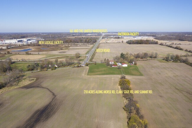
Property Detail
Clark State Rd
Columbus, OH
101.233 AC SEC 5 R15 T1 Q2
063-140550-00.000
LICKING
Agriculturalland
Ohio
B and X Area of moderate flood hazard, usually the area between the limits of the 100-year and 500-year floods.
101.23 AC
2024
Licking County
2024
Columbus
756500
NEARBY LISTINGS FOR SALE OR LEASE
DEMOGRAPHICS near Clark State Rd
1 mile
3 mile
5 mile
2025 Total Population
406
6,353
53,761
2030 Population
416
6,578
55,347
Pop Growth 2025-2030
+ 2.46%
+ 3.54%
+ 2.95%
Average Age
44
41
38
2025 Total Households
164
2,294
18,558
HH Growth 2025-2030
+ 2.44%
+ 3.57%
+ 3.07%
Median Household Inc
$88,888
$113,291
$115,716
Avg Household Size
2.50
2.70
2.80
2025 Avg HH Vehicles
2.00
2.00
2.00
Median Home Value
$324,359
$402,959
$384,897
Median Year Built
1972
1994
2001
Nearby Places
Map Layers
Map Styles
 Street
 Aerial
Transit
 Traffic
 Biking
Places
Listings with unknown addresses are not visible on the map
- Restaurants
- Banks
- Shops
- Fitness
- Groceries
PUBLIC TRANSPORTATION
AIRPORT
John Glenn Columbus International
Drive
Walk
Distance
John Glenn Columbus International
20 min
11.9 mi
Rickenbacker International
Drive
Walk
Distance
Rickenbacker International
35 min
23.4 mi
Freight Ports
Port of Toledo
Drive
Walk
Distance
Port of Toledo
187 min
149.4 mi
SALE & LEASE HISTORY
LISTING DATE
SALE/LEASE

Jul 09, 2019
For Sale
Apr 02, 2019
For Sale
Nearby Properties
Address
Land Use
TOTAL SIZE
Lot Size
Zoning
Address
Land Use
TOTAL SIZE
Lot Size
Zoning
46,000 SF
214.46 AC
Address
Land Use
TOTAL SIZE
Lot Size
Zoning
624,564 SF
104.45 AC
Address
Land Use
TOTAL SIZE
Lot Size
Zoning
141,988 SF
219.25 AC
Address
Land Use
TOTAL SIZE
Lot Size
Zoning
772,217 SF
98.64 AC
Address
Land Use
TOTAL SIZE
Lot Size
Zoning
811,338 SF
222.09 AC
Address
Land Use
TOTAL SIZE
Lot Size
Zoning
271,758 SF
63.69 AC
Address
Land Use
TOTAL SIZE
Lot Size
Zoning
1,435,497 SF
234.05 AC
Address
Land Use
TOTAL SIZE
Lot Size
Zoning
163,020 SF
35 AC
Address
Land Use
TOTAL SIZE
Lot Size
Zoning
154.52 AC
Address
Land Use
TOTAL SIZE
Lot Size
Zoning
446,500 SF
37.26 AC
Address
Land Use
TOTAL SIZE
Lot Size
Zoning
279.62 AC
Address
Land Use
TOTAL SIZE
Lot Size
Zoning
541,500 SF
41.30 AC
Address
Land Use
TOTAL SIZE
Lot Size
Zoning
173,661 SF
40.94 AC
Address
Land Use
TOTAL SIZE
Lot Size
Zoning
506,879 SF
142.43 AC
Address
Land Use
TOTAL SIZE
Lot Size
Zoning
754,614 SF
63.55 AC
Address
Land Use
TOTAL SIZE
Lot Size
Zoning
250,496 SF
15.13 AC
Address
Land Use
TOTAL SIZE
Lot Size
Zoning
351,846 SF
33.05 AC
Address
Land Use
TOTAL SIZE
Lot Size
Zoning
416,945 SF
15.01 AC
Address
Land Use
TOTAL SIZE
Lot Size
Zoning
372,683 SF
18.14 AC
Address
Land Use
TOTAL SIZE
Lot Size
Zoning
280,800 SF
18.07 AC
Address
Land Use
TOTAL SIZE
Lot Size
Zoning
322,252 SF
22.40 AC
Address
Land Use
TOTAL SIZE
Lot Size
Zoning
68,620 SF
25 AC
Address
Land Use
TOTAL SIZE
Lot Size
Zoning
151,476 SF
83.45 AC
Address
Land Use
TOTAL SIZE
Lot Size
Zoning
301,800 SF
27.13 AC
Address
Land Use
TOTAL SIZE
Lot Size
Zoning
303,000 SF
11.49 AC
Address
Land Use
TOTAL SIZE
Lot Size
Zoning
1,809 SF
134.92 AC
Address
Land Use
TOTAL SIZE
Lot Size
Zoning
218,420 SF
24.99 AC
Address
Land Use
TOTAL SIZE
Lot Size
Zoning
234,000 SF
18.29 AC
Address
Land Use
TOTAL SIZE
Lot Size
Zoning
267,500 SF
10.32 AC
Address
Land Use
TOTAL SIZE
Lot Size
Zoning
124,849 SF
11.49 AC
The World's #1 Commercial Real Estate Marketplace
Connect with us
© 2026 CoStar Group
The information above has been obtained from sources believed reliable. While we do not doubt its accuracy we have not verified it and make no guarantee, warranty or representation about it. It is your responsibility to independently confirm its accuracy and completeness. Any projections, opinions, assumptions, or estimates used are for example only and do not represent the current or future performance of the property. The value of this transaction to you depends on tax and other factors which should be evaluated by your tax, financial, and legal advisors. You and your advisors should conduct a careful, independent investigation of the property to determine to your satisfaction the suitability of the property for your needs.