Property Record
Clarkston Rd, Clarkston, MI 48348
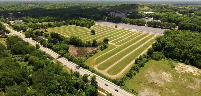

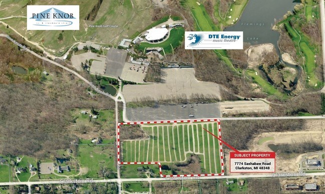

Property Detail
Clarkston Rd
08-15-476-004
T4N, R9E, SEC 15 PART OF SE 1/4 BEG AT PT DIST N 00-15-29 E 331.52 FT FROM SE SEC COR, TH S 89-02-55 W 1327.81 FT, TH N 00-09-48 W 1002.35 FT, TH N 89-23-18 E 809.91 FT, TH S 00-36-42 E 255.71 FT, TH N 89-23-18 E 521.28 FT, TH S 00-15-29 E 738.82 FT
Commercialacreage
OAKLAND
R1R
Michigan
B and X Area of moderate flood hazard, usually the area between the limits of the 100-year and 500-year floods.
27.44 AC
2024
St Clair & Lapeer Counties
2025
Detroit
127100
Detroit-Warren-Dearborn, MI
NEARBY LISTINGS FOR SALE OR LEASE
DEMOGRAPHICS near Clarkston Rd
1 mile
3 mile
5 mile
2025 Total Population
1,971
31,591
80,145
2030 Population
2,044
32,281
81,847
Pop Growth 2025-2030
+ 3.70%
+ 2.18%
+ 2.12%
Average Age
43
42
42
2025 Total Households
701
11,662
31,116
HH Growth 2025-2030
+ 3.85%
+ 2.22%
+ 2.13%
Median Household Inc
$142,382
$117,261
$102,683
Avg Household Size
2.80
2.70
2.50
2025 Avg HH Vehicles
2.00
2.00
2.00
Median Home Value
$465,204
$388,170
$346,280
Median Year Built
1992
1985
1982
Nearby Places
Map Layers
Map Styles
 Street
 Aerial
Layers
 Traffic
 Biking
Places
Listings with unknown addresses are not visible on the map
- Restaurants
- Banks
- Shops
- Fitness
- Groceries
PUBLIC TRANSPORTATION
AIRPORT
Bishop International
Drive
Walk
Distance
Bishop International
46 min
30.5 mi
Freight Ports
Port of Toledo
Drive
Walk
Distance
Port of Toledo
119 min
89.5 mi
SALE & LEASE HISTORY
LISTING DATE
SALE/LEASE

Sep 24, 2016
For Sale
Jan 31, 2017
For Sale
Nearby Properties
Address
Land Use
TOTAL SIZE
Lot Size
Zoning
Address
Land Use
TOTAL SIZE
Lot Size
Zoning
388,304 SF
69.09 AC
R2
Address
Land Use
TOTAL SIZE
Lot Size
Zoning
138,009 SF
8.03 AC
PUD
Address
Land Use
TOTAL SIZE
Lot Size
Zoning
327,435 SF
39.93 AC
R2
Address
Land Use
TOTAL SIZE
Lot Size
Zoning
17.63 AC
R3
Address
Land Use
TOTAL SIZE
Lot Size
Zoning
208,006 SF
1.24 AC
R2
Address
Land Use
TOTAL SIZE
Lot Size
Zoning
64,763 SF
27.90 AC
PUD
Address
Land Use
TOTAL SIZE
Lot Size
Zoning
34,335 SF
74.71 AC
REC
Address
Land Use
TOTAL SIZE
Lot Size
Zoning
249,200 SF
48.39 AC
R2
Address
Land Use
TOTAL SIZE
Lot Size
Zoning
7.18 AC
PUD
Address
Land Use
TOTAL SIZE
Lot Size
Zoning
63,331 SF
10.03 AC
R2
Address
Land Use
TOTAL SIZE
Lot Size
Zoning
35,155 SF
87.55 AC
REC
Address
Land Use
TOTAL SIZE
Lot Size
Zoning
120,673 SF
9.40 AC
IOP
Address
Land Use
TOTAL SIZE
Lot Size
Zoning
33,365 SF
320.73 AC
PRD
Address
Land Use
TOTAL SIZE
Lot Size
Zoning
Address
Land Use
TOTAL SIZE
Lot Size
Zoning
48,645 SF
6.68 AC
PUD
Address
Land Use
TOTAL SIZE
Lot Size
Zoning
49,169 SF
5.02 AC
PUD
Address
Land Use
TOTAL SIZE
Lot Size
Zoning
117,980 SF
11.33 AC
IOP
Address
Land Use
TOTAL SIZE
Lot Size
Zoning
44,915 SF
0.47 AC
PUD
Address
Land Use
TOTAL SIZE
Lot Size
Zoning
31,068 SF
3 AC
PUD
Address
Land Use
TOTAL SIZE
Lot Size
Zoning
2,646 SF
27.22 AC
RMT
Address
Land Use
TOTAL SIZE
Lot Size
Zoning
62,944 SF
6.65 AC
C-2
Address
Land Use
TOTAL SIZE
Lot Size
Zoning
34,807 SF
3.34 AC
OS-2
Address
Land Use
TOTAL SIZE
Lot Size
Zoning
97,730 SF
3.91 AC
PUD
Address
Land Use
TOTAL SIZE
Lot Size
Zoning
20.33 AC
PUD
Address
Land Use
TOTAL SIZE
Lot Size
Zoning
60,282 SF
5.87 AC
C-2
Address
Land Use
TOTAL SIZE
Lot Size
Zoning
8,006 SF
1.24 AC
OS-2
Address
Land Use
TOTAL SIZE
Lot Size
Zoning
28,742 SF
1.87 AC
PUD
Address
Land Use
TOTAL SIZE
Lot Size
Zoning
19.14 AC
PUD
Address
Land Use
TOTAL SIZE
Lot Size
Zoning
72,419 SF
20 AC
RO
Address
Land Use
TOTAL SIZE
Lot Size
Zoning
31,057 SF
5.40 AC
BI
The World's #1 Commercial Real Estate Marketplace
Connect with us
© 2026 CoStar Group
The information above has been obtained from sources believed reliable. While we do not doubt its accuracy we have not verified it and make no guarantee, warranty or representation about it. It is your responsibility to independently confirm its accuracy and completeness. Any projections, opinions, assumptions, or estimates used are for example only and do not represent the current or future performance of the property. The value of this transaction to you depends on tax and other factors which should be evaluated by your tax, financial, and legal advisors. You and your advisors should conduct a careful, independent investigation of the property to determine to your satisfaction the suitability of the property for your needs.