Property Record
2031 Lowery Rd, Morganton, GA 30560

NEARBY LISTINGS FOR SALE OR LEASE
Property Detail
2031 Lowery Rd
0025-007
Steuart Dewar
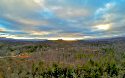
Agriculturalland
8-1 LL146,147,178,179 DB1472-725* 44.25 ACS
A
Fannin
13111C0086E
Georgia
2024
146
2025
44.25 AC
050100
Georgia Northeast
4,244 SF
Other Market Areas
DEMOGRAPHICS near 2031 Lowery Rd
1 Mile
3 Mile
5 Mile
2024 Total Population
406
3,095
8,275
2029 Population
438
3,321
8,878
Pop Growth 2024-2029
+ 7.88%
+ 7.30%
+ 7.29%
Average Age
49
48
48
2024 Total Households
175
1,336
3,607
HH Growth 2024-2029
+ 8.00%
+ 7.19%
+ 7.15%
Median Household Inc
$46,500
$49,160
$48,040
Avg Household Size
2.30
2.30
2.30
2024 Avg HH Vehicles
2.00
2.00
2.00
Median Home Value
$301,852
$279,952
$275,657
Median Year Built
1995
1994
1994
Nearby Places
Map Layers
Map Styles
 Street
 Aerial
- Restaurants
- Banks
- Shops
- Fitness
- Groceries
SALE & LEASE HISTORY
LISTING DATE
SALE/LEASE

Mar 28, 2017
For Sale
Nearby Properties
Address
Land Use
TOTAL SIZE
Lot Size
Zoning
Address
Land Use
TOTAL SIZE
Lot Size
Zoning
20,000 SF
29.93 AC
COMMERCIAL
Address
Land Use
TOTAL SIZE
Lot Size
Zoning
3,160 SF
51.49 AC
RURAL
Address
Land Use
TOTAL SIZE
Lot Size
Zoning
2,990 SF
2.15 AC
COMMERCIAL
Address
Land Use
TOTAL SIZE
Lot Size
Zoning
14,629 SF
5.15 AC
RESIDENTIA
Address
Land Use
TOTAL SIZE
Lot Size
Zoning
2,006 SF
1.50 AC
RESIDENTIA
Address
Land Use
TOTAL SIZE
Lot Size
Zoning
12,600 SF
4.59 AC
RESIDENTIA
Address
Land Use
TOTAL SIZE
Lot Size
Zoning
8,096 SF
25.96 AC
RURAL
Address
Land Use
TOTAL SIZE
Lot Size
Zoning
2,880 SF
1.18 AC
RESIDENTIA
Address
Land Use
TOTAL SIZE
Lot Size
Zoning
6,149 SF
4.32 AC
RESIDENTIA
Address
Land Use
TOTAL SIZE
Lot Size
Zoning
2,624 SF
4.11 AC
RESIDENTIA
Address
Land Use
TOTAL SIZE
Lot Size
Zoning
3,960 SF
9.50 AC
RESIDENTIA
Address
Land Use
TOTAL SIZE
Lot Size
Zoning
1,318 SF
1.64 AC
RESIDENTIA
Address
Land Use
TOTAL SIZE
Lot Size
Zoning
1,076 SF
27.73 AC
RURAL
Address
Land Use
TOTAL SIZE
Lot Size
Zoning
1,842 SF
46.68 AC
RESIDENTIA
Address
Land Use
TOTAL SIZE
Lot Size
Zoning
2,976 SF
1.40 AC
RESIDENTIA
Address
Land Use
TOTAL SIZE
Lot Size
Zoning
4 AC
COMMERCIAL
Address
Land Use
TOTAL SIZE
Lot Size
Zoning
1,932 SF
1.67 AC
RESIDENTIA
Address
Land Use
TOTAL SIZE
Lot Size
Zoning
4,372 SF
1.46 AC
RESIDENTIA
Address
Land Use
TOTAL SIZE
Lot Size
Zoning
36.94 AC
RESIDENTIA
Address
Land Use
TOTAL SIZE
Lot Size
Zoning
1,350 SF
3.49 AC
RESIDENTIA
Address
Land Use
TOTAL SIZE
Lot Size
Zoning
1,564 SF
14.69 AC
RURAL
Address
Land Use
TOTAL SIZE
Lot Size
Zoning
3,756 SF
9.05 AC
EXEMPT
Address
Land Use
TOTAL SIZE
Lot Size
Zoning
56 AC
001
Address
Land Use
TOTAL SIZE
Lot Size
Zoning
30.30 AC
RURAL
Address
Land Use
TOTAL SIZE
Lot Size
Zoning
78 AC
RURAL
Address
Land Use
TOTAL SIZE
Lot Size
Zoning
9,000 SF
0.75 AC
COMMERCIAL
Address
Land Use
TOTAL SIZE
Lot Size
Zoning
7,370 SF
1.37 AC
RESIDENTIA
Address
Land Use
TOTAL SIZE
Lot Size
Zoning
83.15 AC
RURAL
Address
Land Use
TOTAL SIZE
Lot Size
Zoning
2,288 SF
1.83 AC
RESIDENTIA
Address
Land Use
TOTAL SIZE
Lot Size
Zoning
9,060 SF
7.66 AC
RESIDENTIA
The World's #1 Commercial Real Estate Marketplace
Connect with us
© 2025 CoStar Group
The information above has been obtained from sources believed reliable. While we do not doubt its accuracy we have not verified it and make no guarantee, warranty or representation about it. It is your responsibility to independently confirm its accuracy and completeness. Any projections, opinions, assumptions, or estimates used are for example only and do not represent the current or future performance of the property. The value of this transaction to you depends on tax and other factors which should be evaluated by your tax, financial, and legal advisors. You and your advisors should conduct a careful, independent investigation of the property to determine to your satisfaction the suitability of the property for your needs.