Property Record
Clay Dr, Queenstown, MD 21658

Save to a Folder
{{folder.Name}}
{{folder.ListingIds.length}} Properties
{{folder.ListingIds.length}} Property
Create a New Folder
Current Lease Availabilities
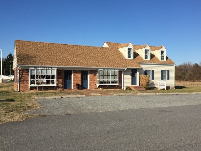
Property Detail
Clay Dr
05-004845
OFFICE BUILDING 11250 SQ FT QUEENSTOWN-CENT RD
Officebuilding
QUEEN ANNES
SR
Maryland
B and X Area of moderate flood hazard, usually the area between the limits of the 100-year and 500-year floods.
0.26 AC
2025
Queen Anne's County
2025
Baltimore
810600
Baltimore-Columbia-Towson, MD
2,236 SF
NEARBY LISTINGS FOR SALE OR LEASE
-
-
View all Queenstown listings for lease on LoopNet.com
DEMOGRAPHICS near Clay Dr
1 mile
3 mile
5 mile
2025 Total Population
1,054
2,862
8,881
2030 Population
1,123
3,060
9,485
Pop Growth 2025-2030
+ 6.55%
+ 6.92%
+ 6.80%
Average Age
42
43
43
2025 Total Households
415
1,108
3,461
HH Growth 2025-2030
+ 6.51%
+ 6.86%
+ 6.79%
Median Household Inc
$109,888
$108,496
$120,754
Avg Household Size
2.50
2.60
2.50
2025 Avg HH Vehicles
2.00
2.00
2.00
Median Home Value
$389,406
$405,312
$472,820
Median Year Built
1979
1984
1988
Nearby Places
Map Layers
Map Styles
 Street
 Aerial
Layers
 Traffic
 Biking
Places
Listings with unknown addresses are not visible on the map
- Restaurants
- Banks
- Shops
- Fitness
- Groceries
PUBLIC TRANSPORTATION
AIRPORT
Baltimore/Washington International Thurgood Marshall
Drive
Walk
Distance
Baltimore/Washington International Thurgood Marshall
61 min
39.9 mi
Freight Ports
Port of Baltimore
Drive
Walk
Distance
Port of Baltimore
67 min
45.1 mi
Nearby Properties
Address
Land Use
TOTAL SIZE
Lot Size
Zoning
Address
Land Use
TOTAL SIZE
Lot Size
Zoning
12,950 SF
8.72 AC
SC
Address
Land Use
TOTAL SIZE
Lot Size
Zoning
69,030 SF
15 AC
SC
Address
Land Use
TOTAL SIZE
Lot Size
Zoning
9,330 SF
710.48 AC
CS
Address
Land Use
TOTAL SIZE
Lot Size
Zoning
50,866 SF
4.37 AC
GGMS
Address
Land Use
TOTAL SIZE
Lot Size
Zoning
60,756 SF
3.57 AC
SE
Address
Land Use
TOTAL SIZE
Lot Size
Zoning
53,927 SF
18.74 AC
SR
Address
Land Use
TOTAL SIZE
Lot Size
Zoning
16,442 SF
3.77 AC
SE
Address
Land Use
TOTAL SIZE
Lot Size
Zoning
3,716 SF
19.15 AC
SI
Address
Land Use
TOTAL SIZE
Lot Size
Zoning
9,600 SF
257.91 AC
AG
Address
Land Use
TOTAL SIZE
Lot Size
Zoning
4,800 SF
5 AC
UC
Address
Land Use
TOTAL SIZE
Lot Size
Zoning
28.02 AC
SC
Address
Land Use
TOTAL SIZE
Lot Size
Zoning
6,400 SF
144.14 AC
SI
Address
Land Use
TOTAL SIZE
Lot Size
Zoning
44,390 SF
0.85 AC
GGMS
Address
Land Use
TOTAL SIZE
Lot Size
Zoning
4,682 SF
2.60 AC
UC
Address
Land Use
TOTAL SIZE
Lot Size
Zoning
9.65 AC
SI
Address
Land Use
TOTAL SIZE
Lot Size
Zoning
21,420 SF
6.17 AC
NC20T
Address
Land Use
TOTAL SIZE
Lot Size
Zoning
12,016 SF
4.36 AC
GGMS
Address
Land Use
TOTAL SIZE
Lot Size
Zoning
11,242 SF
3.13 AC
GGMS
Address
Land Use
TOTAL SIZE
Lot Size
Zoning
120 SF
3.44 AC
Address
Land Use
TOTAL SIZE
Lot Size
Zoning
25,200 SF
1.66 AC
UC
Address
Land Use
TOTAL SIZE
Lot Size
Zoning
7,048 SF
17.76 AC
SR
Address
Land Use
TOTAL SIZE
Lot Size
Zoning
1,260 SF
2.43 AC
SC
Address
Land Use
TOTAL SIZE
Lot Size
Zoning
5.57 AC
SI
Address
Land Use
TOTAL SIZE
Lot Size
Zoning
189.88 AC
CS
Address
Land Use
TOTAL SIZE
Lot Size
Zoning
6.87 AC
SE
Address
Land Use
TOTAL SIZE
Lot Size
Zoning
4,668 SF
0.59 AC
SR
Address
Land Use
TOTAL SIZE
Lot Size
Zoning
7,650 SF
10.28 AC
UC
Address
Land Use
TOTAL SIZE
Lot Size
Zoning
11,360 SF
3.60 AC
NC-1T
Address
Land Use
TOTAL SIZE
Lot Size
Zoning
12,025 SF
1.15 AC
TC
Address
Land Use
TOTAL SIZE
Lot Size
Zoning
10,192 SF
7.16 AC
UC
The World's #1 Commercial Real Estate Marketplace
Connect with us
© 2026 CoStar Group
The information above has been obtained from sources believed reliable. While we do not doubt its accuracy we have not verified it and make no guarantee, warranty or representation about it. It is your responsibility to independently confirm its accuracy and completeness. Any projections, opinions, assumptions, or estimates used are for example only and do not represent the current or future performance of the property. The value of this transaction to you depends on tax and other factors which should be evaluated by your tax, financial, and legal advisors. You and your advisors should conduct a careful, independent investigation of the property to determine to your satisfaction the suitability of the property for your needs.