Property Record
0 Clay Rd, Houston, TX 77084

NEARBY LISTINGS FOR SALE OR LEASE
Property Detail
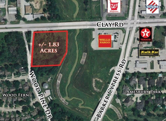
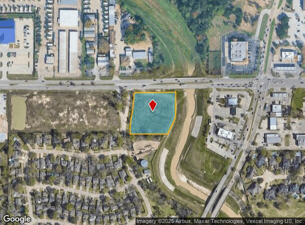
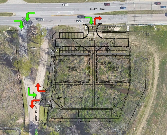
0 Clay Rd
Houston-Pasadena-The Woodlands, TX
Abst 108 J C Bartlett Abst 977 Wcrr Co S
0460770000013
TR 2D & TR 4A-5 ABST 108 J C BARTLETT ABST 977 WCRR CO SEC 22 BLK 2
Commercialacreage
Harris
AE
Texas
48201C0610M
1.84 AC
2024
Katy Freeway West
2025
Houston
541604
DEMOGRAPHICS near 0 Clay Rd
1 Mile
3 Mile
5 Mile
2024 Total Population
11,368
133,319
308,118
2029 Population
11,553
135,541
313,830
Pop Growth 2024-2029
+ 1.63%
+ 1.67%
+ 1.85%
Average Age
38
35
35
2024 Total Households
3,563
40,972
98,252
HH Growth 2024-2029
+ 1.57%
+ 1.67%
+ 1.82%
Median Household Inc
$92,829
$77,358
$78,868
Avg Household Size
3.10
3.20
3.10
2024 Avg HH Vehicles
2.00
2.00
2.00
Median Home Value
$241,501
$195,860
$214,058
Median Year Built
2000
2000
2000
Nearby Places
Map Layers
Map Styles
 Street
 Aerial
- Restaurants
- Banks
- Shops
- Fitness
- Groceries
PUBLIC TRANSPORTATION
AIRPORT
George Bush Intcntl/Houston
DRIVE
WALK
Distance
George Bush Intcntl/Houston
41 min
31.2 mi
William P Hobby
DRIVE
WALK
Distance
William P Hobby
54 min
36.5 mi
Freight Ports
Port of Houston
DRIVE
WALK
Distance
Port of Houston
48 min
33.3 mi
SALE & LEASE HISTORY
LISTING DATE
SALE/LEASE

Oct 26, 2022
For Sale
Nearby Properties
Address
Land Use
TOTAL SIZE
Lot Size
Zoning
Address
Land Use
TOTAL SIZE
Lot Size
Zoning
695,923 SF
6.63 AC
Address
Land Use
TOTAL SIZE
Lot Size
Zoning
681,561 SF
7.98 AC
Address
Land Use
TOTAL SIZE
Lot Size
Zoning
439,347 SF
13.50 AC
Address
Land Use
TOTAL SIZE
Lot Size
Zoning
375,486 SF
12.36 AC
Address
Land Use
TOTAL SIZE
Lot Size
Zoning
341,844 SF
16.71 AC
Address
Land Use
TOTAL SIZE
Lot Size
Zoning
343,605 SF
11.90 AC
Address
Land Use
TOTAL SIZE
Lot Size
Zoning
335,899 SF
12.62 AC
Address
Land Use
TOTAL SIZE
Lot Size
Zoning
331,263 SF
11.36 AC
Address
Land Use
TOTAL SIZE
Lot Size
Zoning
320,084 SF
8.01 AC
Address
Land Use
TOTAL SIZE
Lot Size
Zoning
266,532 SF
6.45 AC
Address
Land Use
TOTAL SIZE
Lot Size
Zoning
284,321 SF
10.54 AC
Address
Land Use
TOTAL SIZE
Lot Size
Zoning
236,406 SF
11.40 AC
Address
Land Use
TOTAL SIZE
Lot Size
Zoning
363,880 SF
17.32 AC
Address
Land Use
TOTAL SIZE
Lot Size
Zoning
305,624 SF
Address
Land Use
TOTAL SIZE
Lot Size
Zoning
323,753 SF
14.02 AC
Address
Land Use
TOTAL SIZE
Lot Size
Zoning
486,927 SF
5.88 AC
Address
Land Use
TOTAL SIZE
Lot Size
Zoning
262,174 SF
11.64 AC
Address
Land Use
TOTAL SIZE
Lot Size
Zoning
335,483 SF
13.83 AC
Address
Land Use
TOTAL SIZE
Lot Size
Zoning
331,923 SF
13.27 AC
Address
Land Use
TOTAL SIZE
Lot Size
Zoning
347,192 SF
16.10 AC
Address
Land Use
TOTAL SIZE
Lot Size
Zoning
119,940 SF
6.13 AC
Address
Land Use
TOTAL SIZE
Lot Size
Zoning
262,492 SF
10.04 AC
Address
Land Use
TOTAL SIZE
Lot Size
Zoning
277,552 SF
15.41 AC
Address
Land Use
TOTAL SIZE
Lot Size
Zoning
392,672 SF
9.73 AC
Address
Land Use
TOTAL SIZE
Lot Size
Zoning
131,152 SF
7.14 AC
Address
Land Use
TOTAL SIZE
Lot Size
Zoning
171,000 SF
7.08 AC
Address
Land Use
TOTAL SIZE
Lot Size
Zoning
179,460 SF
7.58 AC
Address
Land Use
TOTAL SIZE
Lot Size
Zoning
193,160 SF
8.99 AC
Address
Land Use
TOTAL SIZE
Lot Size
Zoning
85,181 SF
5.34 AC
Address
Land Use
TOTAL SIZE
Lot Size
Zoning
228,152 SF
22.61 AC
The World's #1 Commercial Real Estate Marketplace
Connect with us
© 2026 CoStar Group
The information above has been obtained from sources believed reliable. While we do not doubt its accuracy we have not verified it and make no guarantee, warranty or representation about it. It is your responsibility to independently confirm its accuracy and completeness. Any projections, opinions, assumptions, or estimates used are for example only and do not represent the current or future performance of the property. The value of this transaction to you depends on tax and other factors which should be evaluated by your tax, financial, and legal advisors. You and your advisors should conduct a careful, independent investigation of the property to determine to your satisfaction the suitability of the property for your needs.