Property Record
Clemmons Rd, Clemmons, NC 27012
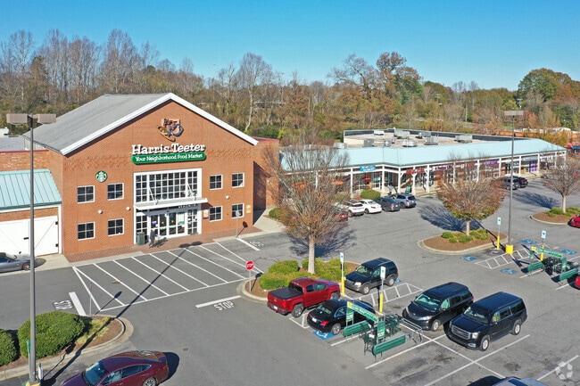

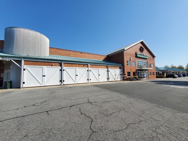
Property Detail
Clemmons Rd
Winston-Salem, NC
TANGLEWOOD COMMONS LO:005 BL:4207X
5882-39-7098
FORSYTH
Regionalshoppingcenterormallwithanchorstore
North Carolina
HB
5
2024
10.64 AC
2025
Clemmons
004014
Greensboro/Winston-Salem
79,498 SF
NEARBY LISTINGS FOR SALE OR LEASE
DEMOGRAPHICS near Clemmons Rd
1 mile
3 mile
5 mile
2025 Total Population
3,312
27,206
57,463
2030 Population
3,382
28,165
59,491
Pop Growth 2025-2030
+ 2.11%
+ 3.52%
+ 3.53%
Average Age
46
44
43
2025 Total Households
1,364
11,050
23,580
HH Growth 2025-2030
+ 2.35%
+ 3.70%
+ 3.66%
Median Household Inc
$85,689
$84,744
$82,386
Avg Household Size
2.30
2.40
2.40
2025 Avg HH Vehicles
2.00
2.00
2.00
Median Home Value
$351,215
$353,665
$336,193
Median Year Built
1988
1991
1992
Nearby Places
Map Layers
Map Styles
 Street
 Aerial
Transit
 Traffic
 Biking
Places
Listings with unknown addresses are not visible on the map
- Restaurants
- Banks
- Shops
- Fitness
- Groceries
PUBLIC TRANSPORTATION
AIRPORT
Piedmont Triad International
Drive
Walk
Distance
Piedmont Triad International
35 min
31.1 mi
SALE & LEASE HISTORY
LISTING DATE
SALE/LEASE

Mar 28, 2017
For Lease
Nearby Properties
Address
Land Use
TOTAL SIZE
Lot Size
Zoning
Address
Land Use
TOTAL SIZE
Lot Size
Zoning
132,856 SF
53.61 AC
R20
Address
Land Use
TOTAL SIZE
Lot Size
Zoning
130,696 SF
41.18 AC
PB-S
Address
Land Use
TOTAL SIZE
Lot Size
Zoning
100,233 SF
19.65 AC
PB-S
Address
Land Use
TOTAL SIZE
Lot Size
Zoning
81,594 SF
1,147.49 AC
IP
Address
Land Use
TOTAL SIZE
Lot Size
Zoning
23,926 SF
11.36 AC
Address
Land Use
TOTAL SIZE
Lot Size
Zoning
121,563 SF
22.42 AC
PB-S
Address
Land Use
TOTAL SIZE
Lot Size
Zoning
60,258 SF
8.04 AC
PB-S
Address
Land Use
TOTAL SIZE
Lot Size
Zoning
99,812 SF
18.33 AC
RM12
Address
Land Use
TOTAL SIZE
Lot Size
Zoning
49,319 SF
24.81 AC
Address
Land Use
TOTAL SIZE
Lot Size
Zoning
1,971 SF
6.24 AC
HB
Address
Land Use
TOTAL SIZE
Lot Size
Zoning
655,160 SF
52.15 AC
GI
Address
Land Use
TOTAL SIZE
Lot Size
Zoning
80,171 SF
4.32 AC
PB-S
Address
Land Use
TOTAL SIZE
Lot Size
Zoning
116,655 SF
10.16 AC
LI
Address
Land Use
TOTAL SIZE
Lot Size
Zoning
60,296 SF
0.66 AC
PB-S
Address
Land Use
TOTAL SIZE
Lot Size
Zoning
68,277 SF
9.82 AC
GB-S
Address
Land Use
TOTAL SIZE
Lot Size
Zoning
71,306 SF
10.36 AC
IP-S
Address
Land Use
TOTAL SIZE
Lot Size
Zoning
129,268 SF
9.98 AC
HB-S
Address
Land Use
TOTAL SIZE
Lot Size
Zoning
75,361 SF
15.20 AC
RM12
Address
Land Use
TOTAL SIZE
Lot Size
Zoning
44,836 SF
14.01 AC
RM12
Address
Land Use
TOTAL SIZE
Lot Size
Zoning
101,346 SF
8.25 AC
HB-S
Address
Land Use
TOTAL SIZE
Lot Size
Zoning
46,073 SF
11.74 AC
R12
Address
Land Use
TOTAL SIZE
Lot Size
Zoning
52,554 SF
25.46 AC
RS9
Address
Land Use
TOTAL SIZE
Lot Size
Zoning
53,969 SF
10.52 AC
RM12-S
Address
Land Use
TOTAL SIZE
Lot Size
Zoning
119,240 SF
22.72 AC
Address
Land Use
TOTAL SIZE
Lot Size
Zoning
32,696 SF
1.64 AC
PB-S
Address
Land Use
TOTAL SIZE
Lot Size
Zoning
32,656 SF
3.14 AC
IP-S
Address
Land Use
TOTAL SIZE
Lot Size
Zoning
68,028 SF
17.56 AC
IP
Address
Land Use
TOTAL SIZE
Lot Size
Zoning
63,600 SF
11.40 AC
NSB-S
Address
Land Use
TOTAL SIZE
Lot Size
Zoning
79,355 SF
14.91 AC
IP-S
The World's #1 Commercial Real Estate Marketplace
Connect with us
© 2026 CoStar Group
The information above has been obtained from sources believed reliable. While we do not doubt its accuracy we have not verified it and make no guarantee, warranty or representation about it. It is your responsibility to independently confirm its accuracy and completeness. Any projections, opinions, assumptions, or estimates used are for example only and do not represent the current or future performance of the property. The value of this transaction to you depends on tax and other factors which should be evaluated by your tax, financial, and legal advisors. You and your advisors should conduct a careful, independent investigation of the property to determine to your satisfaction the suitability of the property for your needs.