Property Record
Cleveland Massillon Rd, Akron, OH 44333
NEARBY LISTINGS FOR SALE OR LEASE
-
-
View all Akron listings for sale on LoopNet.com
Property Detail
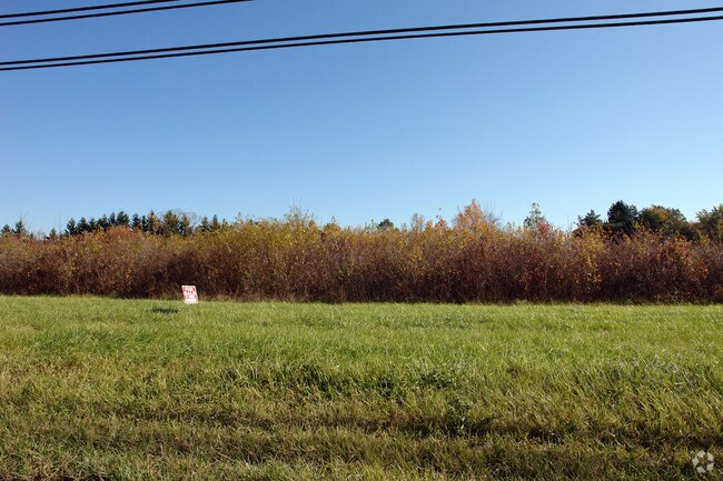
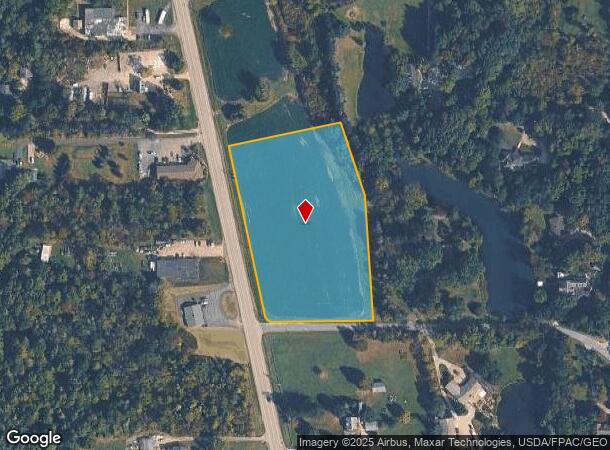
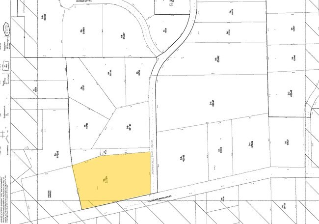
Cleveland Massillon Rd
Akron, OH
Newman Allotment
04-02759
NEWMANS BLK A ALL LESS E PTS 4.4415
Commercialacreage
Summit
X
Ohio
39153C0085F
5,6
2023
4.44 AC
2025
Akron
532302
Cleveland
DEMOGRAPHICS near Cleveland Massillon Rd
1 Mile
3 Mile
5 Mile
2024 Total Population
1,310
7,616
25,268
2029 Population
1,286
7,462
24,912
Pop Growth 2024-2029
(1.83%)
(2.02%)
(1.41%)
Average Age
44
45
46
2024 Total Households
493
2,924
10,158
HH Growth 2024-2029
(1.83%)
(2.05%)
(1.44%)
Median Household Inc
$127,841
$129,745
$115,766
Avg Household Size
2.60
2.60
2.40
2024 Avg HH Vehicles
2.00
2.00
2.00
Median Home Value
$456,617
$435,647
$357,877
Median Year Built
1977
1973
1977
Nearby Places
Map Layers
Map Styles
 Street
 Aerial
- Restaurants
- Banks
- Shops
- Fitness
- Groceries
PUBLIC TRANSPORTATION
COMMUTER RAIL
Indigo Lake (National Park Scenic Railway - Cuyahoga Valley Scenic Railroad)
DRIVE
WALK
Distance
Indigo Lake (National Park Scenic Railway - Cuyahoga Valley Scenic Railroad)
11 min
4.9 mi
Botzum (National Park Scenic Railway - Cuyahoga Valley Scenic Railroad)
DRIVE
WALK
Distance
Botzum (National Park Scenic Railway - Cuyahoga Valley Scenic Railroad)
12 min
5.9 mi
AIRPORT
Cleveland-Hopkins International
DRIVE
WALK
Distance
Cleveland-Hopkins International
40 min
26.2 mi
Akron-Canton Regional
DRIVE
WALK
Distance
Akron-Canton Regional
38 min
27.7 mi
Freight Ports
Port of Toledo
DRIVE
WALK
Distance
Port of Toledo
143 min
120.7 mi
Nearby Properties
Address
Land Use
TOTAL SIZE
Lot Size
Zoning
Address
Land Use
TOTAL SIZE
Lot Size
Zoning
254,133 SF
38.60 AC
Address
Land Use
TOTAL SIZE
Lot Size
Zoning
Address
Land Use
TOTAL SIZE
Lot Size
Zoning
54,592 SF
11.32 AC
Address
Land Use
TOTAL SIZE
Lot Size
Zoning
216,612 SF
16.89 AC
Address
Land Use
TOTAL SIZE
Lot Size
Zoning
72,796 SF
11.49 AC
Address
Land Use
TOTAL SIZE
Lot Size
Zoning
Address
Land Use
TOTAL SIZE
Lot Size
Zoning
87,704 SF
10.02 AC
Address
Land Use
TOTAL SIZE
Lot Size
Zoning
49,530 SF
8.28 AC
Address
Land Use
TOTAL SIZE
Lot Size
Zoning
54,750 SF
8.88 AC
Address
Land Use
TOTAL SIZE
Lot Size
Zoning
111,679 SF
30.05 AC
Address
Land Use
TOTAL SIZE
Lot Size
Zoning
99,468 SF
10.04 AC
Address
Land Use
TOTAL SIZE
Lot Size
Zoning
Address
Land Use
TOTAL SIZE
Lot Size
Zoning
Address
Land Use
TOTAL SIZE
Lot Size
Zoning
Address
Land Use
TOTAL SIZE
Lot Size
Zoning
Address
Land Use
TOTAL SIZE
Lot Size
Zoning
48,928 SF
5.33 AC
Address
Land Use
TOTAL SIZE
Lot Size
Zoning
5,172 SF
370 AC
Address
Land Use
TOTAL SIZE
Lot Size
Zoning
58,977 SF
2.19 AC
Address
Land Use
TOTAL SIZE
Lot Size
Zoning
Address
Land Use
TOTAL SIZE
Lot Size
Zoning
105,120 SF
8.34 AC
Address
Land Use
TOTAL SIZE
Lot Size
Zoning
42,306 SF
2.82 AC
Address
Land Use
TOTAL SIZE
Lot Size
Zoning
55,070 SF
7 AC
Address
Land Use
TOTAL SIZE
Lot Size
Zoning
Address
Land Use
TOTAL SIZE
Lot Size
Zoning
Address
Land Use
TOTAL SIZE
Lot Size
Zoning
59,852 SF
7 AC
Address
Land Use
TOTAL SIZE
Lot Size
Zoning
57,294 SF
9.47 AC
Address
Land Use
TOTAL SIZE
Lot Size
Zoning
81,134 SF
61.23 AC
Address
Land Use
TOTAL SIZE
Lot Size
Zoning
Address
Land Use
TOTAL SIZE
Lot Size
Zoning
24,919 SF
26.34 AC
Address
Land Use
TOTAL SIZE
Lot Size
Zoning
100,659 SF
8.63 AC
The World's #1 Commercial Real Estate Marketplace
Connect with us
© 2025 CoStar Group
The information above has been obtained from sources believed reliable. While we do not doubt its accuracy we have not verified it and make no guarantee, warranty or representation about it. It is your responsibility to independently confirm its accuracy and completeness. Any projections, opinions, assumptions, or estimates used are for example only and do not represent the current or future performance of the property. The value of this transaction to you depends on tax and other factors which should be evaluated by your tax, financial, and legal advisors. You and your advisors should conduct a careful, independent investigation of the property to determine to your satisfaction the suitability of the property for your needs.