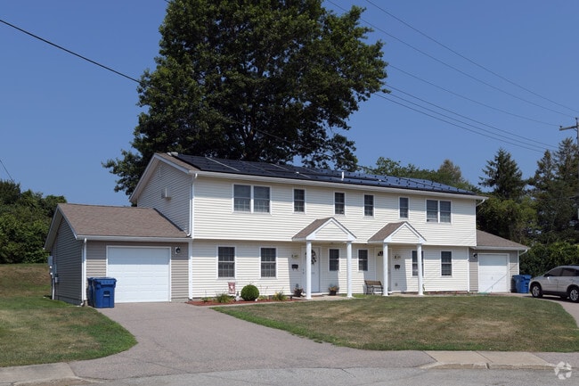
Property Record
Coddington Hwy, Middletown, RI 02840
NEARBY LISTINGS FOR SALE OR LEASE
Property Detail
Coddington Hwy
MIDD-000102-000000-000002
Newport
Apartment
Rhode Island
X
2
44005C0093J
26 AC
2025
Middletown
2025
Providence
0405001
Providence-Warwick, RI-MA
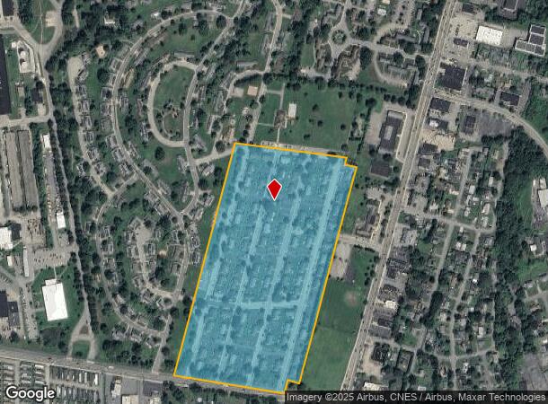
DEMOGRAPHICS near Coddington Hwy
1 mile
3 mile
5 mile
2024 Total Population
3,338
16,750
48,119
2029 Population
3,256
16,225
47,149
Pop Growth 2024-2029
(2.46%)
(3.13%)
(2.02%)
Average Age
39
42
44
2024 Total Households
1,268
6,882
20,484
HH Growth 2024-2029
(2.68%)
(3.46%)
(2.22%)
Median Household Inc
$75,420
$78,509
$89,869
Avg Household Size
2.50
2.30
2.20
2024 Avg HH Vehicles
2.00
2.00
2.00
Median Home Value
$443,299
$452,121
$583,441
Median Year Built
1980
1974
1963
Nearby Places
Map Layers
Map Styles
 Street
 Aerial
Transit
 Traffic
 Biking
Places
Listings with unknown addresses are not visible on the map
- Restaurants
- Banks
- Shops
- Fitness
- Groceries
PUBLIC TRANSPORTATION
AIRPORT
Rhode Island Tf Green International
Drive
Walk
Distance
Rhode Island Tf Green International
46 min
29.2 mi
Freight Ports
Port of Davisville, RI
Drive
Walk
Distance
Port of Davisville, RI
32 min
18.0 mi
Nearby Properties
Address
Land Use
TOTAL SIZE
Lot Size
Zoning
Address
Land Use
TOTAL SIZE
Lot Size
Zoning
60.03 AC
R40
Address
Land Use
TOTAL SIZE
Lot Size
Zoning
264,032 SF
3.73 AC
GB
Address
Land Use
TOTAL SIZE
Lot Size
Zoning
237,976 SF
8.99 AC
WB
Address
Land Use
TOTAL SIZE
Lot Size
Zoning
143,311 SF
2.94 AC
GB
Address
Land Use
TOTAL SIZE
Lot Size
Zoning
104.20 AC
P
Address
Land Use
TOTAL SIZE
Lot Size
Zoning
249,902 SF
27.88 AC
UV
Address
Land Use
TOTAL SIZE
Lot Size
Zoning
24.70 AC
RMA
Address
Land Use
TOTAL SIZE
Lot Size
Zoning
76,534 SF
5.29 AC
WB
Address
Land Use
TOTAL SIZE
Lot Size
Zoning
86,091 SF
6.50 AC
CI
Address
Land Use
TOTAL SIZE
Lot Size
Zoning
157,806 SF
36.80 AC
R30
Address
Land Use
TOTAL SIZE
Lot Size
Zoning
158,333 SF
1.81 AC
R10
Address
Land Use
TOTAL SIZE
Lot Size
Zoning
82.64 AC
Address
Land Use
TOTAL SIZE
Lot Size
Zoning
217,212 SF
10.46 AC
R10
Address
Land Use
TOTAL SIZE
Lot Size
Zoning
33 AC
PA
Address
Land Use
TOTAL SIZE
Lot Size
Zoning
172,320 SF
10.14 AC
R10
Address
Land Use
TOTAL SIZE
Lot Size
Zoning
17.92 AC
RMA
Address
Land Use
TOTAL SIZE
Lot Size
Zoning
108,365 SF
5.15 AC
R10
Address
Land Use
TOTAL SIZE
Lot Size
Zoning
36,984 SF
10 AC
R10
Address
Land Use
TOTAL SIZE
Lot Size
Zoning
151,202 SF
15.98 AC
PA
Address
Land Use
TOTAL SIZE
Lot Size
Zoning
50,220 SF
8.83 AC
TM
Address
Land Use
TOTAL SIZE
Lot Size
Zoning
45,283 SF
1.66 AC
WB
Address
Land Use
TOTAL SIZE
Lot Size
Zoning
12.18 AC
GBA
Address
Land Use
TOTAL SIZE
Lot Size
Zoning
130,460 SF
10.15 AC
OP
Address
Land Use
TOTAL SIZE
Lot Size
Zoning
18,091 SF
6.11 AC
R60
Address
Land Use
TOTAL SIZE
Lot Size
Zoning
96,294 SF
GB
Address
Land Use
TOTAL SIZE
Lot Size
Zoning
64,232 SF
7.69 AC
R20
Address
Land Use
TOTAL SIZE
Lot Size
Zoning
121,259 SF
6.40 AC
GB
Address
Land Use
TOTAL SIZE
Lot Size
Zoning
64,472 SF
4.88 AC
GB
Address
Land Use
TOTAL SIZE
Lot Size
Zoning
56,313 SF
0.53 AC
GB
The World's #1 Commercial Real Estate Marketplace
Connect with us
© 2026 CoStar Group
The information above has been obtained from sources believed reliable. While we do not doubt its accuracy we have not verified it and make no guarantee, warranty or representation about it. It is your responsibility to independently confirm its accuracy and completeness. Any projections, opinions, assumptions, or estimates used are for example only and do not represent the current or future performance of the property. The value of this transaction to you depends on tax and other factors which should be evaluated by your tax, financial, and legal advisors. You and your advisors should conduct a careful, independent investigation of the property to determine to your satisfaction the suitability of the property for your needs.