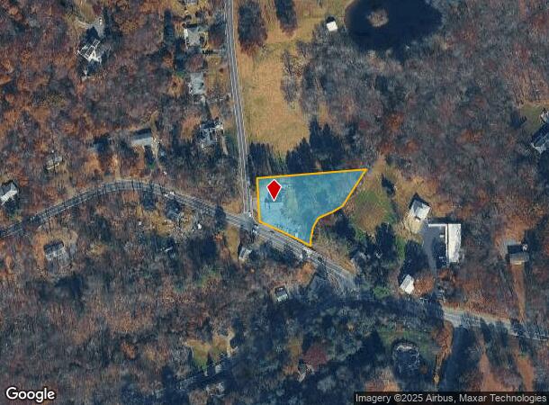
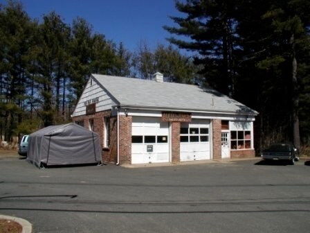
Property Record
Colemans Rd, Washington, NJ 07882


NEARBY LISTINGS FOR SALE OR LEASE
Property Detail
Colemans Rd
Newark, NJ
Morris
38-00018-0000-00010-01
New Jersey
Servicestation
10.1
2024
1.18 AC
2025
Western Morris
032000
Northern New Jersey
DEMOGRAPHICS near Colemans Rd
1 mile
3 mile
5 mile
2024 Total Population
958
10,077
31,418
2029 Population
945
10,003
31,193
Pop Growth 2024-2029
(1.36%)
(0.73%)
(0.72%)
Average Age
43
43
42
2024 Total Households
338
3,549
11,039
HH Growth 2024-2029
(1.48%)
(0.76%)
(0.81%)
Median Household Inc
$131,640
$157,036
$154,419
Avg Household Size
2.80
2.80
2.80
2024 Avg HH Vehicles
2.00
2.00
2.00
Median Home Value
$566,225
$569,081
$538,793
Median Year Built
1975
1974
1975
Nearby Places
Map Layers
Map Styles
 Street
 Aerial
Transit
 Traffic
 Biking
Places
Listings with unknown addresses are not visible on the map
- Restaurants
- Banks
- Shops
- Fitness
- Groceries
PUBLIC TRANSPORTATION
COMMUTER RAIL
Gladstone (Morris & Essex Gladstone Branch - NJ Transit Commuter Rail (NJ Transit))
Drive
Walk
Distance
Gladstone (Morris & Essex Gladstone Branch - NJ Transit Commuter Rail (NJ Transit))
12 min
7.1 mi
Peapack (Morris & Essex Gladstone Branch - NJ Transit Commuter Rail (NJ Transit))
Drive
Walk
Distance
Peapack (Morris & Essex Gladstone Branch - NJ Transit Commuter Rail (NJ Transit))
14 min
8.2 mi
AIRPORT
Newark Liberty International
Drive
Walk
Distance
Newark Liberty International
51 min
36.7 mi
Freight Ports
Maher Terminal
Drive
Walk
Distance
Maher Terminal
55 min
37.3 mi
Nearby Properties
Address
Land Use
TOTAL SIZE
Lot Size
Zoning
Address
Land Use
TOTAL SIZE
Lot Size
Zoning
242 AC
G-I
Address
Land Use
TOTAL SIZE
Lot Size
Zoning
21.56 AC
B-3
Address
Land Use
TOTAL SIZE
Lot Size
Zoning
50.50 AC
R-5
Address
Land Use
TOTAL SIZE
Lot Size
Zoning
104,682 SF
8.96 AC
B-3
Address
Land Use
TOTAL SIZE
Lot Size
Zoning
25.18 AC
R-5
Address
Land Use
TOTAL SIZE
Lot Size
Zoning
610.04 AC
R-5
Address
Land Use
TOTAL SIZE
Lot Size
Zoning
65,914 SF
7.25 AC
B-3
Address
Land Use
TOTAL SIZE
Lot Size
Zoning
14.40 AC
R-1
Address
Land Use
TOTAL SIZE
Lot Size
Zoning
1,516 SF
40.74 AC
R-LD
Address
Land Use
TOTAL SIZE
Lot Size
Zoning
3,328 SF
12.65 AC
B-2
Address
Land Use
TOTAL SIZE
Lot Size
Zoning
222.10 AC
R-3
Address
Land Use
TOTAL SIZE
Lot Size
Zoning
213.55 AC
R-5
Address
Land Use
TOTAL SIZE
Lot Size
Zoning
2,191 SF
5 AC
C-1
Address
Land Use
TOTAL SIZE
Lot Size
Zoning
3.41 AC
C1
Address
Land Use
TOTAL SIZE
Lot Size
Zoning
10,889 SF
2.40 AC
R-HD
Address
Land Use
TOTAL SIZE
Lot Size
Zoning
146 AC
P
Address
Land Use
TOTAL SIZE
Lot Size
Zoning
31,680 SF
3.23 AC
OP
Address
Land Use
TOTAL SIZE
Lot Size
Zoning
34.66 AC
R-5
Address
Land Use
TOTAL SIZE
Lot Size
Zoning
28,260 SF
2.84 AC
B-3
Address
Land Use
TOTAL SIZE
Lot Size
Zoning
5 AC
R-5
Address
Land Use
TOTAL SIZE
Lot Size
Zoning
22,907 SF
1.88 AC
C-2
Address
Land Use
TOTAL SIZE
Lot Size
Zoning
1,331 SF
7.44 AC
R-2
Address
Land Use
TOTAL SIZE
Lot Size
Zoning
44 AC
BE
Address
Land Use
TOTAL SIZE
Lot Size
Zoning
15,040 SF
1.44 AC
B-3
Address
Land Use
TOTAL SIZE
Lot Size
Zoning
1,600 SF
7.80 AC
T-P
Address
Land Use
TOTAL SIZE
Lot Size
Zoning
7,326 SF
11.91 AC
R-5
Address
Land Use
TOTAL SIZE
Lot Size
Zoning
3,360 SF
2.04 AC
R-HD
Address
Land Use
TOTAL SIZE
Lot Size
Zoning
3,971 SF
67.67 AC
R-2
Address
Land Use
TOTAL SIZE
Lot Size
Zoning
6,543 SF
2 AC
R-5
Address
Land Use
TOTAL SIZE
Lot Size
Zoning
12,014 SF
2 AC
R-3
The World's #1 Commercial Real Estate Marketplace
Connect with us
© 2026 CoStar Group
The information above has been obtained from sources believed reliable. While we do not doubt its accuracy we have not verified it and make no guarantee, warranty or representation about it. It is your responsibility to independently confirm its accuracy and completeness. Any projections, opinions, assumptions, or estimates used are for example only and do not represent the current or future performance of the property. The value of this transaction to you depends on tax and other factors which should be evaluated by your tax, financial, and legal advisors. You and your advisors should conduct a careful, independent investigation of the property to determine to your satisfaction the suitability of the property for your needs.