Property Record
College Pkwy, Colchester, VT 05439
NEARBY LISTINGS FOR SALE OR LEASE
-
-
View all Colchester listings for sale on LoopNet.com
Property Detail
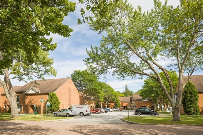
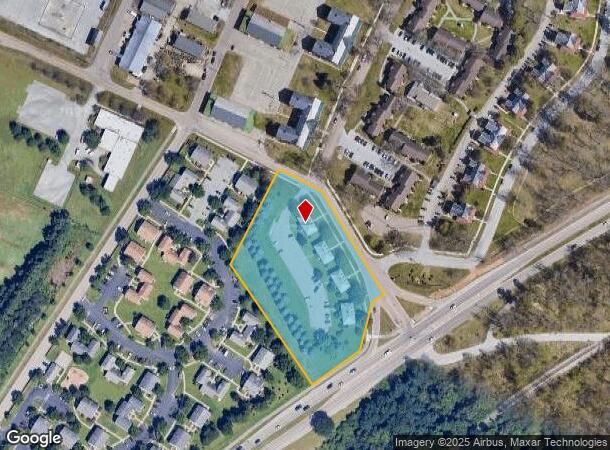
College Pkwy
(048) 01-0160100000000
0 COLLEGE PKWY
Commercialnec
Chittenden
ARE
Vermont
50007C0144D
3.25 AC
2024
Vermont North Area
2024
Other Market Areas
002201
Burlington-South Burlington, VT
DEMOGRAPHICS near College Pkwy
1 Mile
3 Mile
5 Mile
2024 Total Population
4,660
38,017
96,407
2029 Population
4,728
38,400
97,456
Pop Growth 2024-2029
+ 1.46%
+ 1.01%
+ 1.09%
Average Age
34
38
38
2024 Total Households
1,449
16,353
40,463
HH Growth 2024-2029
+ 2.00%
+ 1.03%
+ 1.17%
Median Household Inc
$59,384
$69,858
$75,570
Avg Household Size
2.10
2.10
2.10
2024 Avg HH Vehicles
1.00
2.00
2.00
Median Home Value
$322,093
$325,370
$361,501
Median Year Built
1984
1978
1977
Nearby Places
Map Layers
Map Styles
 Street
 Aerial
- Restaurants
- Banks
- Shops
- Fitness
- Groceries
PUBLIC TRANSPORTATION
COMMUTER RAIL
Essex Junction-Burlington Amtrak Station (Vermonter - Amtrak)
DRIVE
WALK
Distance
Essex Junction-Burlington Amtrak Station (Vermonter - Amtrak)
6 min
2.6 mi
Btn (Ethan Allen Express - Amtrak)
DRIVE
WALK
Distance
Btn (Ethan Allen Express - Amtrak)
11 min
5.0 mi
AIRPORT
Patrick Leahy Burlington International
DRIVE
WALK
Distance
Patrick Leahy Burlington International
11 min
2.9 mi
Plattsburgh International
DRIVE
WALK
Distance
Plattsburgh International
67 min
33.7 mi
Freight Ports
Montreal
DRIVE
WALK
Distance
Montreal
126 min
97.0 mi
Nearby Properties
Address
Land Use
TOTAL SIZE
Lot Size
Zoning
Address
Land Use
TOTAL SIZE
Lot Size
Zoning
2,542,351 SF
34.82 AC
I
Address
Land Use
TOTAL SIZE
Lot Size
Zoning
Address
Land Use
TOTAL SIZE
Lot Size
Zoning
168,175 SF
I
Address
Land Use
TOTAL SIZE
Lot Size
Zoning
2.96 AC
I
Address
Land Use
TOTAL SIZE
Lot Size
Zoning
Address
Land Use
TOTAL SIZE
Lot Size
Zoning
Address
Land Use
TOTAL SIZE
Lot Size
Zoning
27.70 AC
Address
Land Use
TOTAL SIZE
Lot Size
Zoning
232,277 SF
17.20 AC
I
Address
Land Use
TOTAL SIZE
Lot Size
Zoning
28.10 AC
Address
Land Use
TOTAL SIZE
Lot Size
Zoning
Address
Land Use
TOTAL SIZE
Lot Size
Zoning
84.74 AC
Address
Land Use
TOTAL SIZE
Lot Size
Zoning
19.86 AC
I
Address
Land Use
TOTAL SIZE
Lot Size
Zoning
Address
Land Use
TOTAL SIZE
Lot Size
Zoning
98,123 SF
I
Address
Land Use
TOTAL SIZE
Lot Size
Zoning
20.87 AC
RL
Address
Land Use
TOTAL SIZE
Lot Size
Zoning
Address
Land Use
TOTAL SIZE
Lot Size
Zoning
157,081 SF
I
Address
Land Use
TOTAL SIZE
Lot Size
Zoning
181,068 SF
I
Address
Land Use
TOTAL SIZE
Lot Size
Zoning
140,910 SF
2.72 AC
I
Address
Land Use
TOTAL SIZE
Lot Size
Zoning
68,321 SF
4.60 AC
I
Address
Land Use
TOTAL SIZE
Lot Size
Zoning
8,680 SF
45.56 AC
EAE
Address
Land Use
TOTAL SIZE
Lot Size
Zoning
Address
Land Use
TOTAL SIZE
Lot Size
Zoning
107,141 SF
I
Address
Land Use
TOTAL SIZE
Lot Size
Zoning
472,662 SF
23.37 AC
Address
Land Use
TOTAL SIZE
Lot Size
Zoning
Address
Land Use
TOTAL SIZE
Lot Size
Zoning
78,064 SF
2.71 AC
Address
Land Use
TOTAL SIZE
Lot Size
Zoning
Address
Land Use
TOTAL SIZE
Lot Size
Zoning
736.20 AC
Address
Land Use
TOTAL SIZE
Lot Size
Zoning
Address
Land Use
TOTAL SIZE
Lot Size
Zoning
The World's #1 Commercial Real Estate Marketplace
Connect with us
© 2025 CoStar Group
The information above has been obtained from sources believed reliable. While we do not doubt its accuracy we have not verified it and make no guarantee, warranty or representation about it. It is your responsibility to independently confirm its accuracy and completeness. Any projections, opinions, assumptions, or estimates used are for example only and do not represent the current or future performance of the property. The value of this transaction to you depends on tax and other factors which should be evaluated by your tax, financial, and legal advisors. You and your advisors should conduct a careful, independent investigation of the property to determine to your satisfaction the suitability of the property for your needs.